Regional population

This is not the latest release View the latest release

Statistics about the population for Australia's capital cities and regions

Reference period
2021
Released
26/07/2022

Key statistics

  • People living in the capitals increased by 2.5 million (17%) between 2011 and 2021.
  • Melbourne had the largest increase (806,800), Darwin grew the least (19,700).
  • Canberra had the highest growth rate (23%), Adelaide had the lowest (11%).
  • Regional Australia grew by 832,000 (11%).

On 31 August 2023, additional datasets containing final rebased population estimates for 2017 to 2021, based on the 2021 Census were added to this issue. These estimates supersede all estimates from June 2016. Commentary in this product has not been updated with final rebased data.

Any reference to population refers to Estimated Resident Population (ERP).

Any reference to capital city refers to Greater Capital City Statistical Area (GCCSA), and any reference to area refers to Statistical Area Level 2 (SA2). 
Capital cities

Population change

  • Between 2011 and 2021, Melbourne had the largest growth (up by 806,800 people), followed by Sydney (650,800) and Brisbane (421,500).
  • Canberra had the highest growth rate (23%), followed by Brisbane and Perth (both 20%).
Population by capital city
 ERP at 30 June 20212011-21 (no.)2011-21 (%)
Sydney5,259,764650,81514.1
Melbourne4,976,157806,79119.4
Brisbane2,568,927421,49119.6
Adelaide1,402,393138,30210.9
Perth2,192,229358,66219.6
Hobart251,04734,77416.1
Darwin148,80119,69515.3
Canberra453,55885,57323.3
Total capital cities17,252,8762,516,10317.1

Regions

The areas with the largest growth between 2011 and 2021 were:

  • Wollert (up by 24,200 people) in Melbourne's outer north
  • Schofields - East (22,900) in Sydney's outer north-west
  • Mickleham - Yuroke (22,200) also in Melbourne's outer north

The areas with the highest growth rates were:

  • Mickleham - Yuroke (up by 1,400%)
  • Schofields - East (960%)
  • North Kellyville (880%) in Sydney's outer north-west

Outside of the capital cities: 

  • Coomera (up by 11,500 people) on Queensland's Gold Coast had the largest growth 
  • Pimpama - North, also on the Gold Coast, had the highest growth rate (600%)
Areas with the largest growth
SA2SA4ERP at 30 June 20212011-21 (no.)
WollertMelbourne - North East24,76224,234
Schofields - EastSydney - Blacktown25,31422,933
Mickleham - YurokeMelbourne - North West23,73122,152
Wentworth Point - Sydney Olympic ParkSydney - Parramatta20,65317,690
Oran ParkSydney - South West17,75917,555
Areas with the highest growth rates
SA2(a)SA4ERP at 30 June 20212011-21 (%)
Mickleham - YurokeMelbourne - North West23,7311,402.9
Schofields - EastSydney - Blacktown25,314963.2
North KellyvilleSydney - Baulkham Hills and Hawkesbury17,486878.5
Denham Court - BardiaSydney - Outer South West14,958805.4
Jordan Springs - LlandiloSydney - Outer West and Blue Mountains13,481714.6
  1. Excludes SA2s with less than 1,000 people at June 2011.

The areas with the largest and fastest declines were:

  • Mount Isa (down by 2,700 people) in Queensland's north-west
  • Ashburton (-2,400) in Western Australia's north-west
  • South Australia's Outback (down by 40%)

Centre of population

Australia's centre of population: 

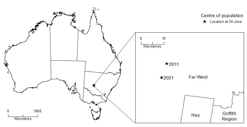
  • was 40 kilometres east of Ivanhoe in western New South Wales, reflecting the concentration of population in south-east Australia
  • moved 6.4 kilometres south over 2011-21, reflecting stronger growth in Melbourne over this period

Centre of population, June 2011 and June 2021

Map showing Australia's centre of population, June 2011 and June 2021
This image shows the location of Australia's centre of population on a map of Australia. The area around the centre of population is zoomed into an SA2 level, showing the locations of the centre of population at at 30 June 2011 and 30 June 2021. These locations are in the Far West SA2, north of Hay SA2 and north-west of Griffith Region SA2 in NSW.

Population density

Australia's population density at June 2021 was 3.3 people per square kilometre (sq km).

The most densely populated areas were: 

  • Melbourne CBD - North (31,100 people per sq km)
  • Southbank - East (20,600) in inner Melbourne
  • Sydney (South) - Haymarket (18,800) in inner Sydney

Population grid

Population density can also be explored at a finer level by breaking Australia up into 1 km² grid cells.

Grid cells can be grouped into population density classes, ranging from no population to very high.

  • Sydney had the largest combined area in the high and very high density classes (175 km²), followed by Melbourne (51 km²) and Brisbane (17 km²).
  • Canberra (2 km²) was the only other capital city to have areas in the high or very high density classes.
Total area (km²) in population density classes by capital city
 No populationVery lowLowMediumHighVery High
 (0)*(Less than 500)*(500-2000)*(2000-5000)*(5000-8000)*(More than 8000)*
Sydney7,0233,47780388612946
Melbourne2,9714,8971,0141,0714110
Brisbane7,0387,559817430152
Adelaide5502,00439030600
Perth2,8422,43371342700
Hobart5361,0251102300
Darwin2,439665532000
Canberra1,8672252016520

* people per square kilometre

New South Wales

Population change

Greater Sydney increased by 650,800 people (14%) between 2011 and 2021, the rest of the state increased by 224,500 (8.6%).

The areas with the largest growth were:

  • Schofields - East (up by 22,900 people) in Sydney's outer north-west
  • Wentworth Point - Sydney Olympic Park (17,700) in Sydney's west
  • Oran Park (17,600) in Sydney's outer south-west

The areas with the highest growth rates were: 

  • Schofields - East (up by 960%)
  • North Kellyville (880%) in Sydney's outer north-west
  • Denham Court - Bardia (810%) in Sydney's outer south-west

Centre of population

The centre for New South Wales: 

  • was near the Hawkesbury River at June 2021, in the suburb of Lower Portland
  • moved 2.6 kilometres south-east over 2011-21, reflecting growth in Sydney and along the NSW coast

The centre for Sydney: 

  • was in the Parramatta River at June 2021, in the suburb of Rydalmere
  • moved around 890 metres west over 2011-21, led by strong growth in outer north-western and south-western suburbs

Population density

The areas with the highest density at June 2021 were: 

  • Sydney (South) - Haymarket (18,800 people per sq km) in inner-city Sydney
  • Chippendale (17,100) also in inner-city Sydney
  • Wolli Creek (16,000) near Sydney's airport

Victoria

Population change

Greater Melbourne increased by 806,800 people (19%) between 2011 and 2021, the rest of the state increased by 203,400 (15%).

The areas with the largest growth were:

  • Wollert (up by 24,200 people) and Mickleham - Yuroke (22,200), both in Melbourne's outer north
  • Cranbourne East - North (16,400) in Melbourne's outer south-east

The areas with the highest growth rates were: 

  • Mickleham - Yuroke (up by 1,400%)
  • Rockbank - Mount Cottrell (540%) in Melbourne's outer west
  • Charlemont (450%), a suburb of Geelong

Centre of population

The centre for Victoria:

  • was in the suburb of Coburg North at June 2021, north of Melbourne’s central business district
  • moved 1.2 kilometres south over 2011-21, reflecting strong growth in the inner Melbourne suburbs

The centre for Melbourne: 

  • was in the suburb of Malvern at June 2021, near the Monash Freeway
  • moved 890 metres west over 2011-21, reflecting strong growth in Melbourne's outer west

Population density

The areas with the highest density at June 2021 were: 

  • Melbourne CBD - North (31,100 people per sq km)
  • Southbank - East (20,600) in inner Melbourne
  • Melbourne CBD - West (16,100)

Queensland

Population change

Greater Brisbane increased by 421,500 people (20%) between 2011 and 2021, the rest of the state increased by 319,400 (14%).

The areas with the largest growth were:

  • Springfield Lakes (up by 13,500 people), a suburb of Ipswich
  • Coomera on the Gold Coast and Murrumba Downs - Griffin in Moreton Bay (both up 11,500)

The areas with the highest growth rates were: 

  • Pimpama - North (up by 600%) on the Gold Coast
  • Ripley (350%), a suburb of Ipswich
  • Dakabin (260%) in Moreton Bay

Centre of population

The centre for Queensland:

  • was in the rural locality of Booubyjan at June 2021, south-west of Maryborough
  • moved 19 kilometres south-east over 2011-21, reflecting strong population growth in South East Queensland

The centre for Brisbane: 

  • was in the suburb of Highgate Hill at June 2021, to the south-west of Brisbane's central business district
  • moved 250 metres south-west over 2011-21, indicating higher growth in Brisbane's outer south-west

Population density

The areas with the highest density at June 2021 were all inner Brisbane suburbs:

  • West End (7,800 people per sq km)
  • Fortitude Valley (7,700)
  • Kangaroo Point (7,400)

South Australia

Population change

Greater Adelaide increased by 138,300 people (11%) between 2011 and 2021, the rest of the state increased by 25,300 (6.7%).

The areas with the largest growth were:

  • Munno Para West - Angle Vale (up by 8,600 people) on the northern outskirts of Adelaide
  • Mount Barker (7,200) in the Adelaide Hills
  • Northgate - Northfield (6,600) in Adelaide's north-east

The areas with the highest growth rates were: 

  • Munno Para West - Angle Vale (up by 110%)
  • Northgate - Northfield (56%)
  • Virginia - Waterloo Corner (49%) in Adelaide's north

Centre of population

The centre for South Australia:

  • was in the suburb of Lightsview at June 2021, in Adelaide's inner north-east
  • moved 1.9 kilometres south over 2011-21, towards Adelaide's central business district

The centre for Adelaide: 

  • was north of Botanic Park at June 2021, in the suburb of Adelaide
  • moved 270 metres north-east over 2011-21, reflecting higher growth in Adelaide's north

​​​​​​​Population density

The areas with the highest density at June 2021 were: 

  • Unley - Parkside (3,000 per sq km) in Adelaide's inner south
  • Prospect (2,900), to the north of Adelaide's central business district
  • Glenelg (also 2,900), a coastal suburb in Adelaide's south-west

Western Australia

Population change

Greater Perth increased by 358,700 people (20%) between 2011 and 2021, the rest of the state increased by 37,800 (7.3%).

The areas with the largest growth were:

  • Baldivis - South (up by 14,800 people) in Perth's outer south-west
  • Alkimos - Eglinton (14,400) in Perth's outer north-west
  • Piara Waters - Forrestdale (12,900) in Perth's south-east

The areas with the highest growth rates were: 

  • Piara Waters - Forrestdale (up by 340%)
  • Brabham - Henley Brook (320%) in Perth's north-east
  • Harrisdale (210%) in Perth's south-east

Centre of population

The centre for Western Australia:

  • was in the Avon Valley National Park at June 2021, 30 kilometres west of the town of Toodyay
  • moved 12 kilometres south-west over 2011-21, towards Perth’s central business district

The centre for Perth: 

  • was in the suburb of Como at June 2021, near the banks of the Swan River
  • moved 510 metres south over 2011-21, reflecting slightly stronger growth to the south of the city

Population density

    The areas with the highest density at June 2021 were: 

    • Perth (North) - Highgate (4,000 people per sq km) in Perth's inner north
    • Scarborough (3,700) on Perth's north-west coastline
    • Tuart Hill - Joondanna (also 3,700) in Perth's inner north

    Tasmania

    Population change

    Greater Hobart increased by 34,800 people (16%) between 2011 and 2021, the rest of the state increased by 21,700 (7.3%).

    The areas with the largest growth were:

    • Kingston - Huntingfield (up by 2,800 people) in Hobart's south
    • Rokeby (2,500) on the eastern shore of the Derwent River
    • Sorell - Richmond (2,300) in Hobart's north-east

    The areas with the highest growth rates were: 

    • Rokeby (up by 45%)
    • Brighton - Pontville (35%) on Hobart's northern fringe
    • Old Beach - Otago (33%) in Hobart's north

    Centre of population

    The centre for Tasmania:

    • was near Woods Lake at June 2021, located in Steppes in the state's Central Highlands
    • moved 4.3 kilometres south-east over 2011-21, reflecting stronger growth in Hobart

    The centre for Hobart: 

    • was just south of the Royal Tasmanian Botanical Gardens at June 2021, in the suburb of Queens Domain
    • moved 190 metres east over 2011-21, reflecting stronger growth in the city's east

    Population density

    The areas with the highest density at June 2021 all surrounded Hobart's central business district: 

    • West Moonah (2,500 people per sq km)
    • Moonah (2,100)
    • Sandy Bay (1,800)

    Northern Territory

    Population change

    Greater Darwin increased by 19,700 people (15%) between 2011 and 2021, while the rest of the territory declined by 1,800 (-1.7%).

    The areas with the largest growth were:

    • Palmerston - South (up by 6,800 people) in Darwin's south-east
    • Lyons (4,200) on the northern fringe of Darwin
    • Rosebery - Bellamack (3,100), also in Darwin's south-east

    The areas with the highest growth rates were: 

    • Lyons (up by 190%)
    • Rosebery - Bellamack (78%)
    • Darwin City (52%)

    Centre of population

    The centre for the Northern Territory:

    • was approximately 40 kilometres south-west of the town of Katherine at June 2021
    • moved 26 kilometres north-west over 2011-21, reflecting growth in and around the capital

    The centre for Darwin: 

    • was in the suburb of Berrimah at June 2021, south of the Stuart Highway
    • moved 570 metres south-east over 2011-21, towards the fast-growing Palmerston area

    Population density

    The areas with the highest density at June 2021 were: 

    • Nightcliff (2,800 people per sq km) in Darwin's northern suburbs
    • Parap (2,700) and Stuart Park (2,600), both inner suburbs of Darwin

    Australian Capital Territory

    Population change

    The number of people living in the Australian Capital Territory increased by 85,600 (23%) between 2011 and 2021.

    The areas with the largest growth were all on Canberra's northern outskirts:

    • Bonner (up by 5,900 people)
    • Moncrieff (5,300)
    • Casey (5,000)

    The areas with the highest growth rates were: 

    • Bonner (up by 410%)
    • Casey (340%)
    • Greenway (180%) in Canberra's south

    Centre of population

    The centre for the Australian Capital Territory:

    • was in Lake Burley Griffin at June 2021, west of the suburb of Acton
    • moved 1.3 kilometres north over 2011-21, reflecting population growth in the northern suburbs

    Population density

    The areas with the highest density at June 2021 were: 

    • Kingston (4,700 people per sq km) on the south-eastern banks of Lake Burley Griffin
    • Braddon (4,600) in Canberra's inner north
    • inner-city Civic (3,500)

    Data downloads

    Data files

    GeoPackages

    Data files

    Population grid files

    Data files

    Data Explorer datasets

    Caution: Data Explorer can be problematic when trying to view and manipulate large datasets, such as SA2-based or LGA geographies released in this product. Please use the Excel data cubes provided above for these datasets. 

    Data in Data Explorer is currently released after the 11:30am release on the ABS website. Please check the reference period when using Data Explorer.

    Post-release changes

    31/08/2023 - Four additional data cubes containing final rebased population estimates for 2017 to 2021 have been added, and all Data Explorer datasets have been updated with final estimates. These estimates supersede all previously released estimates. 

    02/11/2022 - Additional population grid files and an interactive map of the population grid from 2016 to 2021 have been added.

    03/08/2022 - As advertised in this publication on 26 July 2022, this additional release contains interactive maps of population change 2011-21.

    Previous catalogue number

    This release previously used catalogue number 3218.0.

    Back to top of the page