Image of 2016 Australia - QuickStats results page.
User guides and information about Census data tools and products
Census data can be viewed and accessed using different tools. Each has unique key features, formats and provide varying levels of analysis and interpretation. Here we will describe how to use the various tools and outline important information.
Census products provide data for each Census cycle. There is also a Australian Census Longitudinal Dataset which can be used to uncover new insights into the dynamics and transitions that drive social and economic change over time. For further information on the 2021 products available see Census data tools or 2021 Census product release guide.
When viewing Census data please note that small random adjustments have been made to all cell values to protect the confidentiality of respondents. These adjustments may cause the sum of rows or columns to differ by small amounts from table totals.
For more information on the confidentiality of data, the 2021 Census Privacy Statement or Introduced random error/perturbation, please refer to Confidentiality.
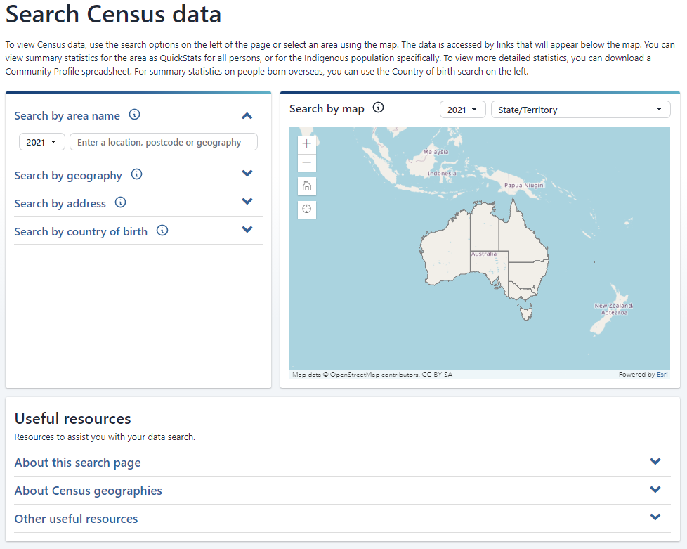
Search Census data is an easy tool that allows you to find Census data about a specific area within Australia. Once an area is selected, you will be able to select the QuickStats or Community Profiles available for that area.
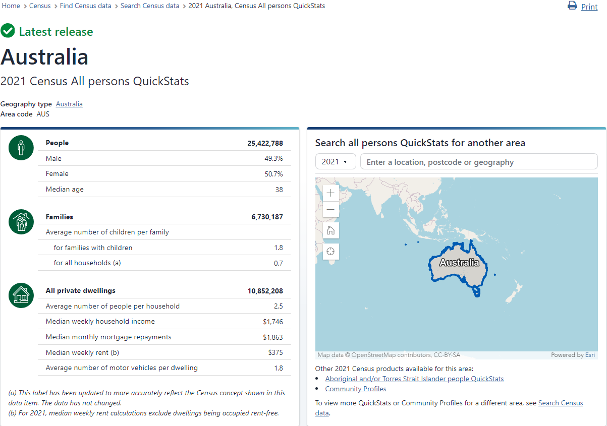
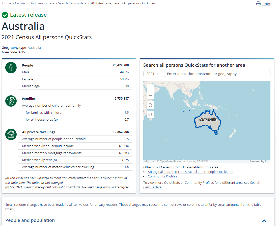
QuickStats are a simple way to understand an area at a glance. They provide a summary of an area including demographics and tables on key characteristics of the people living in the area, their families and their dwellings.
See QuickStats for further information.
Community Profiles provide detailed statistical pictures of areas in Excel spreadsheets. They include predefined tables of Census data and include most topics on the Census form. Community Profiles can be used to compare the social, economic and demographic characteristics of different geographic areas.
See Community Profiles for further information.
Search Census data provides different ways to find data for a selected area. Using one of the options, search by Census year and area of interest to see links to data about the area underneath the map.
QuickStats are a simple way to understand an area at a glance. They provide a summary of an area including demographics and tables on key characteristics of the people living in the area, their families and their dwellings.
For a selected area, Census data is grouped into categories and displayed in tables and compared to the state or territory and national data. QuickStats data in the 'Persons' category is based on place of usual residence, while data in the 'Families' and 'Dwellings' categories is based on place of enumeration.
The categories are:
Small random adjustments have been made to all cell values to protect the confidentiality of respondents. These adjustments may cause the sum of rows or columns to differ by small amounts from table totals.
For more information on the confidentiality of data, the 2021 Census Privacy Statement or introduced random error, refer to Confidentiality.
QuickStats can be found by using the Search Census data tool. This tool is in the 'Find Census data tile', on the Census homepage.
The Search Census data tool provides you with different ways to find data for a selected area, including QuickStats and Community Profiles. Using one of the options, search by Census year and area of interest to see links to QuickStats for the area.
For more information about how to use Search Census data, see Search Census data user guide.
There are three types of QuickStats.
All person QuickStats provides:
To find a list of the All person QuickStats topics, see the 2021 Census product release guide.
This QuickStats provides information about Aboriginal and Torres Strait Islander people and dwellings. Aboriginal and Torres Strait Islander QuickStats are available for the following geographies:
Aboriginal and Torres Strait Islander QuickStats are available from 2016 onwards.
To find a list of the Aboriginal and Torres Strait Islander people QuickStats topics, see the 2021 Census product release guide.
Country of birth QuickStats provides summary characteristics of people who were born overseas. It includes data on the person, their families and dwellings in which they live. This data is available for the:
Country of birth QuickStats are available for the following geographies:
While all the top countries are available for selection, when combined with certain geographies no data will be available due to low counts. Once a country of birth has been selected, the user is prompted to select a geography. This list will not include any low count areas.
To find a list of the Country of birth QuickStats topics, see the 2021 Census product release guide.
The countries available in this search are determined by the count of persons who report being born in that country. Data on families and households is determined by the responses of the usual residents who were present in the household on Census Night.
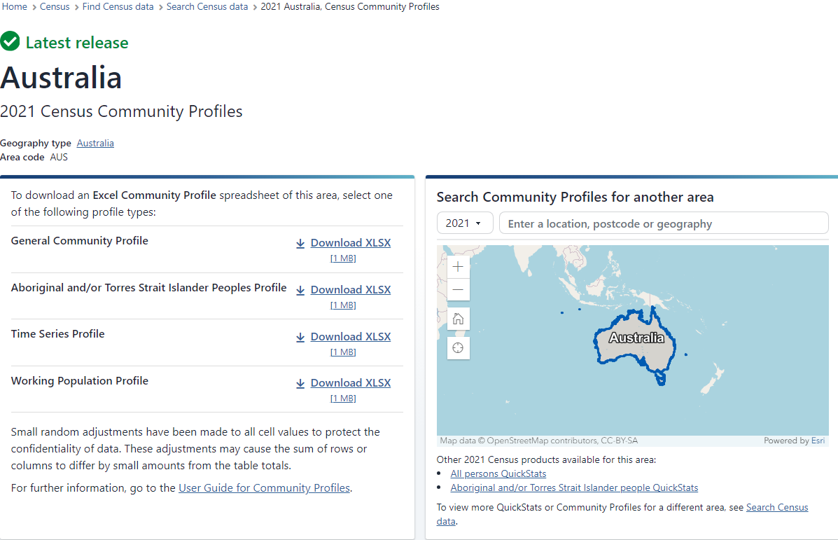
Community Profiles are tools for researching, planning and analysing geographic areas for a number of social, economic and demographic characteristics. Community Profiles provide a comprehensive statistical picture of an area in Excel spreadsheet, delivering data relating to people, families, and dwellings.

Small random adjustments have been made to all cell values to protect the confidentiality of respondents. These adjustments may cause the sum of rows or columns to differ by small amounts from table totals.
For more information on the confidentiality of data, the 2021 Census Privacy Statement or Introduced random error/perturbation, please refer to Confidentiality.
Community Profiles can be found by using the Search Census data tool. This tool is in the Find Census data tile, on the Census homepage.
The Search Census data tool provides you with different ways to find data for a selected area, including Community Profiles and QuickStats. Using one of the options, search by Census year and area to see links to Community Profiles.
For more information about how to use Search Census data, see Search Census data user guide.
Community Profiles templates are blank Community Profiles without data. These templates can be used to understand what data will be released in Community Profiles and the format of the tables and spreadsheets.
To view the Community Profile templates, see Download product templates.
There are four types of Community Profiles that can be downloaded.
The General community profile is based on place of usual residence and contains tables showing the characteristics of persons, families and dwellings in a selected geographic area.
These tables are available for a variety of geographic regions, ranging from national and state level down to Statistical Area Level 2.
Before 2016, the General community profile was referred to as the Basic community profile and Expanded community profile.
General community profiles are available from 1996 onwards.
For more information regarding the release of the 2021 General community profile, its tables and topics, see 2021 Census product release guide.
The Aboriginal and Torres Strait Islander people profile is based on place of usual residence and provides characteristics about Aboriginal and Torres Strait Islander people, families and dwellings.
Some tables include comparisons with non-Indigenous people.
The Aboriginal and Torres Strait Islander peoples profile is available for the following geographies:
The Aboriginal and Torres Strait Islander people profile is available from 2001 onwards.
For more information regarding the release of the 2021 Aboriginal and Torres Strait Islander people profile, its tables and topics, see 2021 Census product release guide.
The 2021 Time series profile presents data from the 2011, 2016 and 2021 Censuses based on the geographical boundaries from the 2021 Census.
Where a data classification has been revised between censuses, data will be output on the classification that has been used in the 2021 Census.
When interpreting the results from different time periods, take care as censuses are based on a point in time. Changes to the Census form design, collection procedures and processing may impact the comparability of data. The data is based on place of usual residence. The Time series profile is available for the following geographies:
The Time series profile is available from 2001 onwards.
For more information regarding the release of the 2021 Time series profile, its tables and topics, see 2021 Census product release guide.
The Working population profile contains key Census characteristics of employed persons, based on the person’s place of work. The profile includes data on:
The Working population profile is available for the following geographies:
The Working population profile is available from 2001 onwards.
For more information regarding the release of the 2021 Working population profile, its tables and topics, see 2021 Census product release guide.
TableBuilder is a flexible way to access detailed data where you can:
Tables are automatically treated to protect privacy and confidentiality before the output is provided to you.
To gain access to Census TableBuilder, you need to register using your organisation email address.
Information on how to register and use TableBuilder can be found here.
To view the TableBuilder data item list, see Microdata and TableBuilder: Census of Population and Housing Data downloads.
Designed for complex data queries such as detailed analysis and modelling on appropriately confidentialised unit record data.
The Census microdata files comprise of:
Before applying for access, users should read the Responsible use of ABS microdata user guide to understand the obligations when using microdata.
To apply, see How to access in MicrodataDownload and DataLab.
To view the data item lists, see Microdata and TableBuilder: Census of Population and Housing Data downloads.
DataPacks contain comprehensive data about people, families and dwellings for all Census geographies ranging from Australia down to Statistical Area Level 1 (SA1). They are containers of data based on Census Community Profiles and include digital boundary information, metadata and reference documents to enable you to read the data.
DataPacks are suitable for experienced Census data users who have their own databases or analysis systems. Use DataPacks if you want Community Profile data for numerous geographic areas.
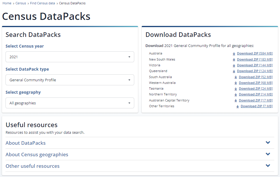
To access DataPacks, navigate to the Census homepage, select the ‘Find Census data’ tile, select ‘Census data tools’, and then select ‘DataPacks’.
DataPacks are based on all Community Profiles with an additional profile.
The Community Profiles in brief are:
DataPack templates are blank DataPacks without data. These templates can be used to understand what data will be released in DataPacks and the format of the files.
To view the DataPack templates, see Download product templates.
You will need the following software to use DataPacks:
DataPacks are downloaded as a .zip file which includes three sub-folders:
Descriptors are column headings in the data files that display each data label. There are three types of descriptors: Sequential, Short and Long.
A descriptor type for 2011 DataPacks will need to be selected before downloading. 2016 and 2021 DataPacks default to short descriptors.
Should you require data using a different descriptor, you can replace headers in the CSV files using descriptor information available in the Metadata contained in the zip file.
The examples below show the different type of descriptors for the same geography.
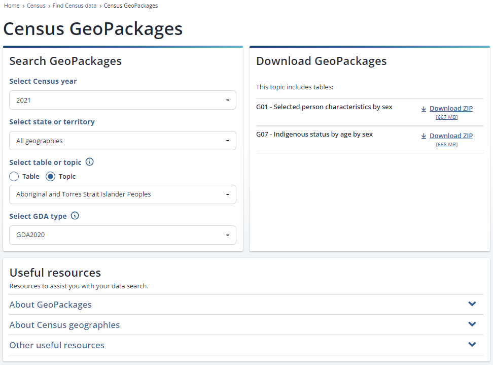
GeoPackages contain comprehensive data about people, families and dwellings for Census geographical areas ranging from Statistical Areas Level 1 to the whole of Australia. GeoPackages are Census data linked to geographical boundary data from the Australian Statistical Geography Standard (ASGS) in a database container.
GeoPackages are suitable for experienced Census data users who want Community Profile data for numerous locations and have their own databases or Geographic Information System (GIS) software. GeoPackages do not include software.
GeoPackage is an open, non-proprietary, platform-independent and standards-based data format for geographic information system implemented as a database container. Originally designed to meet mobile geospatial needs, it is becoming a preferred means for exchanging geospatial datasets and the associated base maps and layers as a single ready-to-use file.
GeoPackage is based on a technology called SQLite, which is a lightweight, public domain database system. If you know SQLite, then you are most of the way to understanding GeoPackage. Most modern Geographical Information systems and tools (for example: MapInfo, ArcMap, QGIS, FME and others) support GeoPackage, making it a powerful and widely adopted geospatial data interchange format.
Visit the GeoPackage website for information on the specification for GeoPackage and implementations and examples.
To access GeoPackages, navigate to the Census homepage, select the ‘Find Census data’ tile, select ‘Census data tools’, and then select ‘GeoPackages’.
Choose from 2016 or 2021.
Each GeoPackage includes the following geographies that can be downloaded at either an Australia or State/Territory level.
| ABS Structures | Non-ABS structures |
|---|---|
| Greater Capital City Statistical Areas (GCCSA) | Local Government Areas (LGA) |
| Statistical Areas Level 4 (SA4) | Suburbs and Localities (SAL), State Suburbs (SSC) |
| Statistical Areas Level 3 (SA3) | Postal Areas (POA) |
| Statistical Areas Level 2 (SA2) | Commonwealth Electoral Divisions (CED) |
| Statistical Areas Level 1 (SA1) | State Electoral Divisions (SED) |
| Significant Urban Areas (SUA) | |
| Urban Centres and Localities (UCL) | |
| Section of State (SOS) | |
| Section of State Ranges (SOSR) | |
| Remoteness Areas (RA)* |
*Available mid 2023, for more information, see 2021 Census product release guide.
GeoPackages are based on the General community profile. The General community profile contains Census characteristics on persons, families and dwellings.
For 2016, GeoPackages are downloadable by a General community profile topic. See GeoPackages topics for more information. For 2021, GeoPackages are downloadable by a General community profile table. You can view which tables relate to each topic by selecting 'Topic'.
Digital boundaries are available in both the Geocentric Datum of Australia 2020 (GDA2020) and the Geocentric Datum of Australia 1994 (GDA94). GDA2020 was adopted as the new official national datum in 2017 and will be adopted gradually by organisations across Australia. The difference between GDA94 and GDA2020 on the ground is currently about 1.8 metres. Eventually, the ABS will phase out GDA94 boundaries.
For more information about GDA2020, please refer to the Intergovernmental Committee on Surveying and Mapping or Geoscience Australia.
Some topics can have multiple GeoPackages. It is recommended you read the tables included in each GeoPackage (found beneath the ‘Download GeoPackage’ heading) to ensure you are downloading the correct data for your analysis.
Once you have selected the criteria above, the corresponding GeoPackage will appear underneath the ‘Download GeoPackage’ heading. Each GeoPackage can be downloaded as a ZIP file.
Please note that there are small random adjustments made to all cell values to protect the confidentiality of respondents. These adjustments may cause the sum of rows or columns to differ by small amounts from the table totals.
(does not contain actual data)
(does not contain actual data)
(does not contain actual data)
(does not contain actual data)
The short descriptor file contains a small error for table G11. The correct titles for the column headers are "_05_10_" instead of "_06_10".
(does not contain actual data)
(does not contain actual data)
(does not contain actual data)
(does not contain actual data)
This data item list contains the variables available in the various Census aggregate products (QuickStats, Community Profiles, DataPacks, GeoPackages)
To view the TableBuilder data item list, see Microdata and TableBuilder: Census of Population and Housing Data downloads.
Updates to downloads on this page were made on 22 October 2024.