Main Structure and Greater Capital City Statistical Areas
The Main Structure of the Australian Statistical Geography Standard (ASGS) is developed by the ABS and is used to release and analyse a broad range of social, demographic and economic statistics. It is also widely used by other organisations. The structure is broadly based on the concept of a functional area. A functional area is an area within which many people commute or travel to access services.
The structure has seven hierarchical levels listed below in descending order:
- Australia (AUS)
- States and Territories (S/T)
- Statistical Areas Level 4 (SA4s)
- Statistical Areas Level 3 (SA3s)
- Statistical Areas Level 2 (SA2s)
- Statistical Areas Level 1 (SA1s)
- Mesh Blocks (MBs)
Each level directly aggregates to the level above. For example, SA1s are aggregates of Mesh Blocks and they in turn aggregate to SA2s. This principle continues up through the remaining levels of the hierarchy. At each hierarchical level, all of Geographic Australia is covered without gaps or overlaps.
Greater Capital City Statistical Areas (GCCSAs), while not a part of the Main Structure hierarchy, are geographic regions that are also designed to represent functional areas.
For ASGS Edition 3, the number of records within each region type by State and Territory and Australia wide, is shown below.
| Region | NSW | Vic. | Qld | SA | WA | Tas. | NT | ACT | OT | Aust. | Total* |
|---|---|---|---|---|---|---|---|---|---|---|---|
| S/T | 1 | 1 | 1 | 1 | 1 | 1 | 1 | 1 | 1 | 9 | 10 |
| GCCSA | 4 | 4 | 4 | 4 | 4 | 4 | 4 | 3 | 3 | 34 | 35 |
| SA4 | 30 | 19 | 21 | 9 | 12 | 6 | 4 | 3 | 3 | 107 | 108 |
| SA3 | 94 | 68 | 84 | 30 | 36 | 17 | 11 | 12 | 6 | 358 | 359 |
| SA2 | 644 | 524 | 548 | 176 | 267 | 101 | 70 | 136 | 6 | 2,472 | 2,473 |
| SA1 | 19,750 | 15,482 | 12,549 | 4,329 | 6,352 | 1,482 | 649 | 1,229 | 22 | 61,844 | 61,845 |
| MB | 112,738 | 88,739 | 71,862 | 28,431 | 43,322 | 13,034 | 3,361 | 6,662 | 136 | 368,285 | 368,286 |
*Total varies from the Australia count by one as it includes a new special purpose code for Outside Australia.
For information on how the Main Structure and GCCSAs relate to the whole ASGS, refer to the ASGS diagram.
Mesh Blocks
Mesh Blocks are the smallest geographic areas defined by the ABS and form the building blocks for the larger regions of the Australian Statistical Geography Standard (ASGS). They broadly identify land use such as residential, commercial, primary production and parks. Statistical Areas Level 1 (SA1s) are generally the smallest geographic unit used to release Census of Population and Housing data; however, for ASGS Edition 3, limited Census of Population and Housing data may also be available at the Mesh Block level.
ASGS Edition 3 contains 368,286 Mesh Blocks covering the whole of Australia without gaps or overlaps. This includes 114 non-spatial special purpose codes including a new Outside Australia code. These non-spatial Mesh Blocks represent populations that are difficult to define geographically such as people who are in transit or have no fixed address. Migratory and No Usual Address are examples of this type of Mesh Block.
The Non ABS structures that will be approximated from Mesh Blocks include Local Government Areas, Postal Areas, Suburbs and Localities (formerly State Suburbs), Commonwealth Electoral Divisions, State Electoral Divisions, Australian Drainage Divisions and Destination Zones.
As Mesh Blocks are very small they can be combined together to accurately approximate a large range of other geographies.
Mesh Block design criteria
Mesh Blocks for ASGS Edition 3 are designed according to a standard set of criteria first developed for ASGS 2011. All of the criteria considered are listed below in approximate order of importance.
Please note that the order of importance for some criteria may change depending on whether an area is urban or rural. For example, in urban areas, the requirement for dwelling counts over 30 takes precedence over the requirement to match locality boundaries. In rural areas however, matching locality boundaries sometimes takes precedence over minimum dwelling requirements because of the flow on effect Mesh Block design has on other structures in the hierarchy.
Land use
Mesh Blocks reflect dominant land use where possible. For example, residential areas are separated from commercial or industrial areas. Wherever possible, each Mesh Block is designed to have a single land use, for example parkland, but this is not always possible. Land use is recorded in the Mesh Block category attribute according to the criteria below.
- Residential: will mainly contain houses, duplexes, apartments, townhouses, gated communities, caravan parks, retirement villages, residential military bases, and prisons. Where possible, residential areas are separated from other land uses.
- Commercial: will contain a number of businesses, and where possible, will have a zero population count. Some commercial Mesh Blocks may contain population, for example, where a residential flat is above a shop.
- Industrial: will contain a number of businesses, and where possible, will have a zero population count.
- Parkland: will mainly contain parks, nature reserves, public open space, and other minimal use protected or conserved areas and, where possible, will have a zero population count. Parkland Mesh Blocks may also include sporting arenas or facilities, including racecourses, golf courses and stadiums. These facilities may not be open to the public.
- Education: will contain education facilities, and may contain population in non-private dwellings such as boarding schools or universities.
- Hospital/Medical: will contain hospital or medical facilities. This may include aged care facilities, which are distinguished from larger retirement villages.
- Transport: will contain road or rail features and, where possible, will have a zero population count.
- Primary Production: a Mesh Block is classified as Primary Production when available information indicates that more than half of the area is used for primary production.
- Water: will mainly contain various bodies of water including lakes, rivers and canals, and where possible will have a zero population count.
- Other: includes Mesh Blocks which could not be easily placed in one of the other nine categories due to the nature of the land use, or due to evidence of high mixed use. Many Mesh Blocks which were classified as agricultural in earlier editions of the ASGS are now classified as other.
Dwellings
Mesh Blocks are designed where possible to contain between 30 and 60 dwellings, with some low dwelling count Mesh Blocks permitted to accommodate other design criteria. The minimum dwelling count of Mesh Blocks is designed to be small enough to aggregate accurately to a wide range of areas and to enable a ready comparison of statistics between geographic regions. The Mesh Block target size helps the ABS protect against accidental disclosure of confidential information.
Zero Mesh Blocks
Zero Mesh Blocks are created to capture areas with no population, such as airports, commercial or industrial developments, and large shopping complexes.
Growth
Mesh Blocks are created in anticipation of development which is likely to occur before the date of the 2021 Census of Population and Housing.
Cadastre
Where practical, Mesh Block boundaries do not cross cadastral (property) boundaries. Mesh Blocks are designed to be an aggregation of land parcels.
Roads
Mesh Blocks follow road centre lines where possible. Roads, particularly major roads such as highways and motorways, are used as Mesh Block boundaries where possible.
Single polygon
Each Mesh Block is a single area, for example every island is a single Mesh Block.
Suburbs and Localities (or rural suburbs)
Where possible, Mesh Blocks are designed to contain or aggregate to whole officially gazetted suburbs or localities, especially in rural areas.
Major facility
Mesh Blocks, where possible, contain an entire major facility. This includes hospitals, universities, airports, correctional centres, and retirement villages, which occupy a large area of land, extend across both sides of a street, or have an internal road network.
High density housing
High density housing (such as apartment blocks) have been identified and are included in individual Mesh Blocks of compact shape, where possible. This means that some Mesh Blocks have more than 60 dwellings.
Communities of interest
Mesh Blocks aim to group communities of interest together. For example, a whole apartment building, residential complex, parking lot, shopping complex or retirement village is contained in one Mesh Block, if possible.
Town blocks
Where possible in urban areas, Mesh Blocks reflect town blocks.
Accessibility
Where possible, all dwellings/buildings are to be accessible by road or pathway from within the Mesh Block so that communities of interest are grouped together. For example the houses on a cul-de-sac are contained in one Mesh Block and therefore boundaries may follow a back fence.
Shape
Where practical, Mesh Blocks are designed to be compact in size and shape, especially in urban areas.
Continuity
Natural and man-made barriers, such as main roads, are used as boundaries in order to keep communities together. This means that if a Mesh Block boundary runs along a main road then adjacent Mesh Block boundaries will follow the same road if possible. This will provide consistency and continuity in the aggregated regions made from Mesh Blocks.
Topography
Mesh Block boundaries reflect topographic, or landscape, features where practical.
The topographic features used for Mesh Block design include:
- water bodies such as rivers and lakes
- transportation such as roads and rail
- open space such as parkland, nature reserves and forest
- major mountain ranges or escarpments
Mesh Block name criteria
Mesh Blocks are not named.
Mesh Block coding structure
The 11-digit Mesh Block code comprises: State and Territory identifier (1 digit), and a Mesh Block identifier (10 digits).
| S/T | MB |
|---|---|
| 6 | 0106840000 |
Mesh Block changes
Some Mesh Block redesign has occurred for the release of ASGS Edition 3. This redesign is necessary to ensure that Mesh Blocks continue to meet the criteria set out above, and so that they remain relevant by reflecting the growth and change in Australia's population, economy and infrastructure.
Changes to Mesh Block boundaries occur where growth and development have taken place since the last edition of the ASGS in 2016. Boundaries were modified in the simplest way possible to facilitate comparison over time. Where changes were made, they were undertaken to ensure long term stability into the future.
This redesign has in turn affected the coding of the Mesh Blocks. Where a 2016 Mesh Block has been split or significantly redesigned, the original 2016 Mesh Block code has been retired and replaced with a new, previously unused code for ASGS Edition 3.
Some design changes to boundaries that reflect changes to physical infrastructure, such as realigned roads, do not result in the movement between Mesh Blocks of substantial numbers of households or businesses, or land area. These changes have been made for cartographic purposes to ensure that the ASGS boundaries can be used with standard mapping data. They are not considered to be significant and have not resulted in code changes.
Statistical Area Level 1
Statistical Areas Level 1 (SA1s) are geographic areas built from whole Mesh Blocks. Whole SA1s aggregate to form Statistical Areas Level 2 (SA2s). SA1s are designed to maximise the geographic detail available for Census of Population and Housing data. However, limited Census of Population and Housing data may also be available at the Mesh Block level for ASGS Edition 3.
There are 61,845 SA1 regions covering the whole of Australia without gaps or overlaps. This includes 34 non-spatial special purpose codes including a new Outside Australia code. These non-spatial SA1s represent populations that are difficult to define geographically such as people who are in transit or have no fixed address. Examples include the Migratory and No Usual Address SA1s.
SA1s are also used as the building blocks for some ASGS geographies, including the Indigenous Structure, Significant Urban Areas, Urban Centres and Localities, Section of State Structure, and the Remoteness Structure.
SA1 design criteria
SA1s are designed using multiple criteria, listed below in approximate order of importance.
Population
SA1s generally have a population of 200 to 800 people, and an average population of about 400 people. SA1s in remote and regional areas generally have smaller populations than those in urban areas. Some low population count SA1s were permitted to accommodate other design criteria.
Aboriginal and Torres Strait Islander population
SA1s are designed to represent Aboriginal and Torres Strait Islander communities as accurately as possible, particularly in remote areas.
Urban and rural
SA1s are designed to be either urban or rural in character.
Urban SA1s contain one or more of the following:
- residential development with a density of over 200 people per square kilometre
- built infrastructure including: ports, airports with paved runways, industrial, commercial and retail development, large sporting complexes, education campuses, places of worship, military camps and research stations
- local parks and playgrounds
- local sports facilities and ovals
- vegetation corridors
- golf courses
- cemeteries
- lakes, rivers, riverbanks, creeks and drainage reserves surrounded by development of an urban character
- sewerage facilities, waste disposal facilities, hospitals, transport hubs, and grain storage
Rural SA1s contain one or more of the following:
- residential development with a density of less than 200 people per square kilometre
- agriculture
- national parks
- defence reserves
- indigenous lands
- mines
- stockyards
- lakes, rivers, riverbanks, creeks and drainage reserves not surrounded by development of an urban character
Transport
SA1s are generally internally connected by road transport. Exceptions include islands, which are either combined with the nearest onshore SA1 or grouped with other islands.
Suburbs and localities (or rural suburbs)
Where possible, SA1s are designed to contain, or aggregate to, whole gazetted suburbs or rural localities. In urban areas, the gazetted suburbs usually consist of one or more SA1s.
In regional and remote areas, gazetted localities are sometimes too small to represent as an SA1. Smaller localities are grouped together based on their Local Government Area, the use of shared road networks, the use of shared community facilities, and landscape features such as location within a valley.
Growth
SA1s are created in anticipation of development which is likely to occur before the date of the 2021 Census of Population and Housing.
Prisons
Prisons, remand centres and juvenile detention centres with a population of over 200 people are generally represented by their own SA1.
Defence bases
Defence bases with a population of over 200 people are generally represented by their own SA1.
Zero SA1s
Zero SA1s are SA1s with a nil population. They are created to represent large unpopulated areas that are not easily combined with surrounding populated SA1s.
They may include one or more of the following:
- airports
- ports
- commercial developments
- industrial developments
- large shopping complexes
- large sporting complexes
- large educational campuses
- research stations
- large cemeteries
- golf courses
- national parks
- large urban parks
- defence reserves
- restricted Commonwealth land
- groups of unpopulated islands
- very large areas of land which are unlikely to ever be populated, for example extreme desert or otherwise inhospitable terrain
- lakes
SA1 name criteria
SA1s are not named.
SA1 coding structure
SA1s are identified by an 11-digit fully hierarchical code, comprising the 1-digit State and Territory, and Statistical Areas Level 1-4 identifiers. The SA1 identifier is a 2-digit code, assigned within an SA2. An SA1 code is only unique within a State or Territory when it is preceded by the State or Territory identifier.
| S/T | SA4 | SA3 | SA2 | SA1 |
|---|---|---|---|---|
| 5 | 03 | 02 | 1041 | 18 |
The ABS previously provided an additional, short 7-digit code for SA1s. Short codes are not included in ASGS Edition 3 to reduce confusion. Support is available via statistical consultancies for users that need support to transition from using 7-digit to 11-digit codes.
In the future, it may be necessary to allocate new codes. If an SA1 is discontinued, or changes significantly for new editions of the ASGS, the SA1 identifier will be retired and the replacement SA1s will be given the next available previously unused SA1 identifier within the SA2.
Statistical Area Level 2
Statistical Areas Level 2 (SA2s) are medium-sized general purpose areas built up from whole Statistical Areas Level 1 (SA1s). Their purpose is to represent a community that interacts together socially and economically.
There are 2,473 SA2s covering the whole of Australia without gaps or overlaps. This includes 19 non-spatial special purpose codes including a new Outside Australia code. These non-spatial SA2s represent populations that are difficult to define geographically such as people who are in transit or have no fixed address. These are represented by Migratory – Offshore – Shipping and No Usual Address SA2s.
SA2s are generally the smallest areas used for the release of ABS non-Census of Population and Housing statistics, including Estimated Resident Population and Health and Vitals data. Whole SA2s aggregate to form Statistical Areas Level 3 (SA3s). SA2s are also used to build Significant Urban Areas and to approximate Tourism Regions.
SA2 design criteria
SA2s are designed using multiple criteria, listed below in approximate order of importance.
Population
SA2s generally have a population between 3,000 and 25,000 with an average of about 10,000 people. SA2s in remote and regional areas generally have smaller populations than those in urban areas. There are some SA2s outside these target population ranges due to other considerations including:
- The relative sparseness of the population in remote regions (an SA2 with a population of 3,000 may cover too large and diverse a geographic area to be meaningful).
- The benefit of preserving recognisable areas for which there is a considerable amount of historical data.
- Isolated geographic areas, such as islands or other isolated populations.
- The need to avoid subdivisions of otherwise coherent regions, such as very large suburbs or regional towns.
Functional areas
A functional area is the area from which people come to access services at a centre. This centre may be a rural town, a regional city, a commercial and transport hub within a major city, or the major city itself. The concept of a functional area is used at all levels of the ABS Main Structure and is particularly essential to the design of SA2s outside of major urban areas.
A centre and its functional area are represented by one or more SA2s. A rural town and its functional area may be combined into a single SA2. A larger town may be identified by a single SA2 and its functional area around the town by a second SA2. Larger towns and regional cities may be represented by several SA2s.
Within cities, SA2s represent gazetted suburbs rather than functional areas.
In remote areas, SA2s are designed to represent meaningful regions, useful for statistical analysis.
Growth
SA2s containing regional towns or on the fringes of larger cities are designed to contain the urban area, any immediately associated semi urban development, and likely growth areas in the next 10 to 20 years. This is to ensure that the SA2 boundaries remain stable over several population and housing censuses.
Suburbs and Localities (or rural suburbs)
Where possible, SA2s consist of whole gazetted suburbs or rural localities. This is to make the regions as meaningful as possible to users unfamiliar with statistical geography and to facilitate address coding to other ASGS units.
In regional and remote areas, gazetted localities are usually too small to be represented by a single SA2 and are combined with neighbouring areas to represent a functional area or other meaningful region.
In major cities, SA2s often represent single suburbs. Suburb size is variable within and between cities and they do not always make a convenient region to be used directly as an SA2. Where this occurs, five general criteria are used to cluster smaller suburbs together or break up extremely large suburbs:
- shared road networks
- shared community facilities
- Local Government Areas
- shared historical or social links
- socio-economic similarity
Local Government Areas
Local Government Areas (LGAs) are considered in the design of SA2s and are often adopted where the LGA boundary satisfies one or more of the following:
- it closely aligns with gazetted suburb boundaries
- it reflects the underlying settlement pattern
- it represents the functional area of a regional town or city
- it has a high degree of recognition among stakeholders
- it aligns to a significant recognisable geographic feature
Zero SA2s
Zero SA2s have a nil population. They are created to represent large unpopulated areas that are not easily combined with surrounding populated SA2s.
They may include:
- major infrastructure (such as ports and airports)
- significant bodies of water
- major commercial and industrial zones
- national parks
- defence land
- very large urban parks
- very large sporting precincts
SA2 name criteria
The key criteria for SA2 names are that they be:
- meaningful
- have a maximum of 50 characters
- unique, that is not shared by any other SA2 in Australia
In large urban areas, SA2s are named for the gazetted suburbs they contain.
- Where an SA2 is made from a single suburb, it will retain the name of the suburb, for example “Curtin”.
- Where a single large suburb is split into more than one SA2, it will retain the name of the suburb and a geographic identifier, for example “Mount Waverley – North”.
- Where an SA2 is made up from 2 or 3 suburbs, the SA2 name is a concatenation of the suburb names, for example “Greenfield Park – Prairiewood”.
- Where an SA2 is made up of 4 or more suburbs it will be named for the larger or more prominent suburbs, or given a local identifier, for example “Belgrave - Selby”.
In rural areas, SA2s are named for the gazetted localities they contain, or the towns, cities, or regions with which they are associated, for example:
- Benalla Surrounds
- Townsville – South
- Bulahdelah – Stroud
In previous editions of the ASGS, SA2s surrounding towns have been referred to as “X Region”, even when the town was not included in that SA2. In ASGS Edition 3, SA2s which do not include the town have been renamed to “X Surrounds” to reduce confusion. For example, “Cooma Region”, does not include the town of Cooma so it has been renamed to “Cooma Surrounds”.
Where an SA2 name appears in two or more State and Territories, the State or Territory abbreviation is attached to the SA2 name, for example:
- O’Connor (ACT)
- O’Connor (WA)
SA2 coding structure
An SA2 is identifiable by a 9-digit fully hierarchical code comprising the 1-digit State or Territory identifier, and Statistical Areas Level 2-4 identifiers. The SA2 identifier is a 4-digit code, assigned in alphabetical order within an SA3. An SA2 code is only unique within a State or Territory if it is preceded by the State or Territory identifier.
| S/T | SA4 | SA3 | SA2 | SA2 Name |
|---|---|---|---|---|
| 5 | 03 | 02 | 1295 | East Perth |
The ABS previously provided a short, 5-digit code for SA2s. Short codes are not included in ASGS Edition 3 to reduce confusion. Support is available via statistical consultancies for users that need support to transition from using 5-digit to 9-digit codes.
In the future, it may be necessary to allocate new codes. If an SA2 is discontinued, or changes significantly for new editions of the ASGS, the SA2 identifier will be retired and the replacement SA2s will be given the next available previously unused SA2 identifier within the State or Territory.
Statistical Area Level 3
Statistical Areas Level 3 (SA3s) are geographic areas built from whole Statistical Areas Level 2 (SA2s). They are designed for the output of regional data, including 2021 Census of Population and Housing data. SA3s create a standard framework for the analysis of ABS data at the regional level through clustering groups of SA2s that have similar regional characteristics. Whole SA3s aggregate to form Statistical Areas Level 4 (SA4s).
There are 359 SA3s covering the whole of Australia without gaps or overlaps. This includes 19 non-spatial special purpose codes including a new Outside Australia code. These non-spatial SA3s represent populations that are difficult to define geographically, such as people who are in transit or have no fixed address. These are represented by Migratory – Offshore – Shipping and No Usual Address SA3s.
The Other Territories of Jervis Bay, Cocos (Keeling) Islands, Christmas Island and Norfolk Island are each represented by individual SA3s.
SA3 design criteria
SA3s are designed using multiple criteria, listed below in approximate order of importance.
Population
In general, SA3s are designed to have populations between 30,000 and 130,000 people. However, the creation of meaningful regional areas takes priority over population criteria. As a result, there are some SA3s with populations above 130,000 or below 30,000.
Functional areas
SA3s are often the functional areas of regional towns and cities with a population in excess of 20,000 or clusters of related suburbs around urban commercial and transport hubs within the major urban areas.
Identifying regions
SA3s create a standard framework for the analysis of ABS data at the regional level through clustering groups of SA2s that have similar geographic and socio-economic characteristics. In many cases, these areas are defined by existing administrative boundaries, such as State Regional Development Areas or one or more Local Government Areas.
Zero SA3
Zero SA3s have a nil population. They are created to represent large unpopulated areas that are not easily combined with surrounding populated SA3s, such as large national parks on the fringes of large urban areas.
SA3 name criteria
The key criteria for SA3 names are that they be:
- meaningful
- have a maximum of 50 characters
- unique, that is not shared by any other SA3 in Australia
SA3s are named according to the areas they represent.
- Where an SA3 represents a well-known regional area or a State Regional Development Area it is named after that region, for example “Southern Highlands”.
- Where an SA3 represents the functional area of a regional city it is named after that city, for example “Wagga Wagga”. In some cases the name of an associated town or region is also included, for example “Griffith - Murrumbidgee (West)”.
- Where an SA3 represents an economic hub within a major city it is generally named to reflect that hub, for example “Parramatta”.
- Where an SA3 represents a group of related suburbs it is named after one or more of those suburbs that reflect its location, for example “North Sydney – Mosman”.
- Where an SA3 name is not unique within Australia, it is followed by the State and Territory abbreviation in brackets, for example “Central Highlands (Tas.)”.
SA3 coding structure
SA3s are identified by 5-digit hierarchical codes. This comprises a 1-digit State or Territory identifier followed by a 2-digit SA4 identifier, unique within each State and Territory, and a 2-digit SA3 identifier, unique within each SA4.
| S/T | SA4 | SA3 | SA3 Name |
|---|---|---|---|
| 1 | 14 | 01 | Shoalhaven |
Statistical Area Level 4
Statistical Area Level 4 (SA4s) are geographic areas built from whole Statistical Areas Level 3 (SA3s). SA4s are the largest sub-state regions in the Main Structure of the ASGS and are designed for the output of a variety of regional data, including data from the 2021 Census of Population and Housing. SA4 boundaries represent labour markets and the functional area of Australian capital cities respectively. They are designed with an emphasis on stability over time to support the time series of statistical releases such as the Quarterly Labour Force publication. These areas represent labour markets or groups of labour markets within each state and territory.
Whole SA4s aggregate to Greater Capital City Statistical Areas and States and Territories. There are 108 SA4s covering the whole of Australia without gaps or overlaps. This includes 19 non-spatial special purpose codes including a new Outside Australia code. These non-spatial SA4s represent populations that are difficult to define geographically such as people who are in transit or have no fixed address. These are represented by Migratory – Offshore – Shipping and No Usual Address SA4s.
The Other Territories of Jervis Bay, Cocos (Keeling) Islands, Christmas Island and Norfolk Island are together represented by a single SA4.
SA4 design criteria
SA4s are designed using multiple criteria, listed below in approximate order of importance.
Population
Most SA4s have a population above 100,000 people to provide sufficient sample size for Labour Force estimates. In regional areas, SA4s tend to have smaller populations of 100,000 to 300,000 people. In cities, SA4s tend to have larger populations of 300,000 to 500,000 people.
Labour markets
SA4s are designed to incorporate both labour supply (where people live) and demand (where people work). This enhances the quality of statistical outputs related to labour markets.
The ABS consulted with experts on labour market geography and undertook analysis of the Census of Population and Housing travel to work data to identify labour markets within Australia. The resulting labour markets are characterised by a large number of very small regional labour markets, a smaller number of medium sized labour markets around regional centres, and very large labour markets representing the major city centres. While this may be an accurate reflection of Australian labour markets, many of the regions did not meet the minimum population criterion.
SA4s are designed to represent the labour markets of the largest regional cities such as Wollongong, Bendigo and Townsville. SA4s present specific labour force data on these cities’ labour markets.
In outer regional and remote areas, labour markets tend to be small and localised around regional towns. SA4s in these areas represent aggregations of these labour markets based on geographic, social and economic similarities. SA4s which contain only remote and regional areas enable a picture of regional and remote labour force activity to be presented.
Smaller regional labour markets are combined based on travel to work interactions, as well as industry and regional similarities, to create SA4s of about 100,000 to 300,000 people. Medium sized regional centre labour markets that exceeded 100,000 people (for example Cairns, Qld) are preserved as far as possible as SA4s that directly represent the labour market, though in some cases small closely related labour markets are included in these SA4s. Very large labour markets of 300,000 to 500,000 people are split to reflect major employment hubs and their main labour supply catchments.
SA4 name criteria
The key criteria for SA4 names are that they be:
- meaningful
- have a maximum of 50 characters
- unique, that is not shared by any other SA4 in Australia
SA4s are named according to the areas they represent:
- Where an SA4 represents a labour market of a major city it is named after that city, for example “Bendigo”.
- Where an SA4 represents an employment centre within a larger city it is generally named to reflect both the larger city and the employment centre or part of the city that it represents, for example “Melbourne - Inner South”.
- Where an SA4 represents a collection of labour markets in regional areas it is named using either a description of that part of the state and territory or after one or more well-known regional areas that it closely replicates, for example “Latrobe – Gippsland”.
- Where the name does not identify it within Australia, it is generally preceded by the State or Territory name, for example “Western Australia - Wheat Belt”.
SA4 coding structure
SA4s are identified by a 3-digit hierarchical code. This comprises a 1-digit State or Territory identifier, which precedes a 2-digit SA4 identifier, unique within each State and Territory.
| S/T | SA4 | SA4 name |
|---|---|---|
| 1 | 02 | Central Coast |
Greater Capital City Statistical Areas
Greater Capital City Statistical Areas (GCCSAs) are geographic areas built from Statistical Areas Level 4 (SA4s). GCCSA boundaries represent labour markets and the functional area of Australian capital cities respectively. They are designed with an emphasis on stability over time to support the time series of statistical releases such as the Quarterly Labour Force publication.
There are 16 GCCSAs covering the whole of Australia without gaps or overlaps. The GCCSA boundaries may differ from official or commonly applied area boundaries. There are 8 regions covering each of the Australian state and territory capital cities; 7 regions covering the rest of each state and the Northern Territory (ACT only has one GCCSA region for the entire Territory); and a region covering Other Territories which includes Jervis Bay, Christmas Island, Cocos (Keeling) Islands and Norfolk Island.
In addition to these 16 GCCSA regions are 19 non-spatial special purpose codes, for a total of 35 GCCSAs. These non-spatial GCCSAs represent populations that are difficult to define geographically such as people who are in transit or have no fixed address. These special purpose codes include Migratory – Offshore – Shipping and No Usual Address for each State and Territory, as well as a new Outside Australia code.
GCCSA design criteria
GCCSAs are designed to represent the functional area of each of the eight State and Territory capital cities which includes populations who regularly socialise, shop or work within the city, but may live either in the city or in the small towns and rural areas surrounding the city. Within each State and Territory, the area not included in the GCCSA is represented by a Rest of State region. GCCSAs do not have population criteria.
GCCSA name criteria
GCCSAs are named according to the cities they represent, for example “Greater Sydney”. The remainder of the State and Territory is named Rest of <State>, for example “Rest of NSW”. The exceptions to this are the ACT, as the whole of the ACT is included in the GCCSA, and the Other Territories, which do not have a capital city.
GCCSA coding structure
A GCCSA is identified by a 5-character alphanumeric code. This comprises a 1-digit State or Territory identifier followed by a 4-character GCCSA identifier that is unique within each State and Territory.
| S/T | GCCSA identifier |
|---|---|
| 1 | GSYD |
Australia and State/Territory
Australia is the largest geographic area in the Main Structure of the ASGS. The ASGS uses the geographic definition of Australia described in further detail in the definition of Australia section of this publication.
To align with the ISO 3166 standard, the ASGS Edition 3 code for Geographic Australia is identified by the unique three-character alpha code of AUS which replaces the three-digit numeric code of 036 (also ISO 3166 standard) as used in ASGS 2016.
Australia is broken up into the States and Territories that are separately recognised in the ASGS:
- New South Wales
- Victoria
- Queensland
- South Australia
- Western Australia
- Tasmania
- Northern Territory
- Australian Capital Territory
- Other Territories (Jervis Bay Territory, Territory of Christmas Island, Territory of the Cocos (Keeling) Islands and Norfolk Island)
The ASGS State and Territory boundaries are a cartographic representation of legally designated boundaries and therefore should not be used for legal purposes. In general, the total area of each State and Territory, including their offshore islands, is used for statistical purposes as a separate geographic area in the ASGS. However, the Jervis Bay Territory, and the Territories of Christmas Island, Cocos (Keeling) Islands and Norfolk Island are included as one geographic area at the State and Territory level under the category of Other Territories.
States and Territories consist of one or more Statistical Areas Level 4 (SA4). In aggregate, they cover Australia without gaps or overlaps.
Australia and State/Territory coding structure
States and Territories are identified by unique one-digit codes as follows:
| Code | State or Territory name |
|---|---|
| 1 | New South Wales |
| 2 | Victoria |
| 3 | Queensland |
| 4 | South Australia |
| 5 | Western Australia |
| 6 | Tasmania |
| 7 | Northern Territory |
| 8 | Australian Capital Territory |
| 9 | Other Territories |
Special purpose codes
Special purpose codes allow address data to be coded to a non-spatial value. This occurs where there is insufficient information to code to a physical geographic area. For example, where someone is in transit on Census of Population and Housing night or where an incomplete address has been supplied.
Types of special purpose codes
- Migratory - used to code people who are in transit on long distance trains, buses, aircraft and long haul road transport vehicles on Census of Population and Housing night.
- Offshore - used to code people living offshore for example on oil rigs and drilling platforms. It is also used for expeditioners in the Australian Antarctic Territory.
- Shipping - used to code people who are on board vessels in Australian waters which are in, or between, Australian ports on Census of Population and Housing night. For Mesh Blocks there are multiple Shipping special purpose codes that represent individual ports.
- Outside Australia - used to facilitate particular ABS statistical releases. It does not have a geographic region and has a code of “ZZZZ” so that it can be easily distinguished from all other geographies.
- No Usual Address - used to code people with no fixed residential address.
Special purpose coding structure
The following examples show the special purpose code structure for Mesh Blocks in NSW.
| S/T | Mesh Blocks | Description |
|---|---|---|
| 1 | 8000000778 | MIGRATORY |
| 1 | 9000000779 | OFFSHORE |
| 1 | 7000005777 | SHIPPING |
| 1 | 7000004777 | SHIPPING |
| 1 | 7000003777 | SHIPPING |
| 1 | 7000002777 | SHIPPING |
| 1 | 7000001777 | SHIPPING |
| S/T | Mesh Blocks | Description |
|---|---|---|
| 1 | 0000009499 | No Usual Address |
| S/T | Mesh Blocks | Description |
|---|---|---|
| Z | ZZZZZZZZZZ | Outside Australia |
Collection specific coding conventions
ABS collections use various conventions to denote circumstances such as: not applicable, and overseas visitors.
Changes from the previous edition of the ASGS
Overall, the Main Structure and Greater Capital City Statistical Areas (GCCSAs) provides high stability and good statistical comparability to ASGS 2016. Changes to Mesh Blocks, Statistical Areas Level 1 (SA1s) and Statistical Areas Level 2 (SA2s) mainly reflect population growth, largely on the edge of urban areas. In this edition there are no major changes to Statistical Areas Level 3 (SA3s), Statistical Areas Level 4 (SA4s), or GCCSAs.
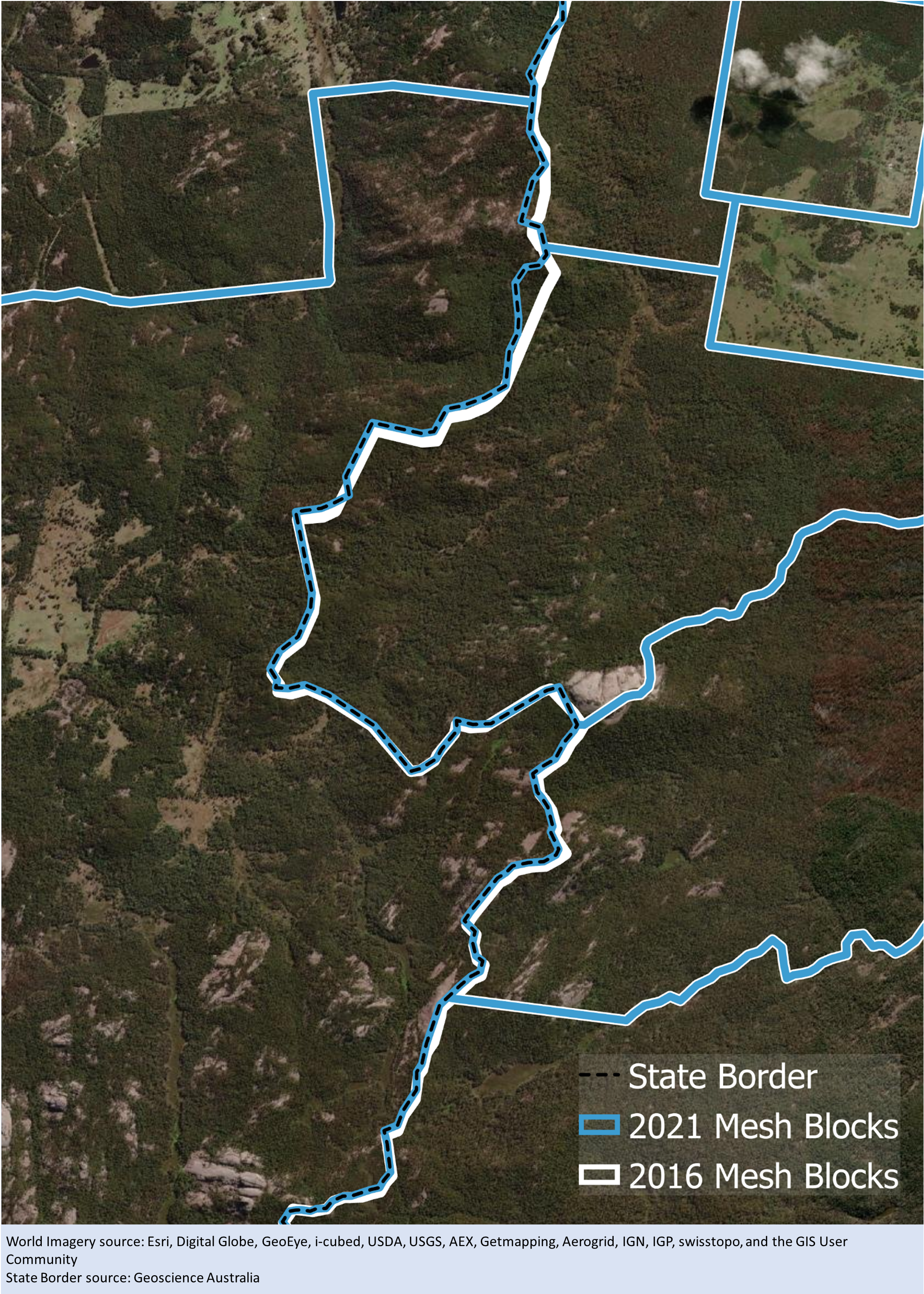
All boundaries have been aligned with updated state and territory borders. Figure 2 shows an example of this type of change. There may also be other alignment changes to align with source data. These are very minor differences in cartographic representations to the ASGS boundaries and are not considered significant.
Figure 2 - Example of Mesh Block change along the Qld/NSW border
Alignment shifts for state and territory borders will be evident in area correspondences between ASGS Edition 3 and previous ASGS editions. However, most population based correspondences will not be affected as alignment has not affected any dwellings.
When analysing population data, ASGS Edition 3 can be successfully compared to previous editions of the ASGS for time series. There may be some cases, for example when using environmental data, where alignment changes will need to be considered.
Significant changes
Alterations to Mesh Blocks, SA1s and SA2s are made, primarily through splitting areas, to mirror changes occurring on the ground, such as new housing developments or altered transport infrastructure. These changes reflect recent population growth, and allow users to access meaningful statistics on communities of interest. The resulting net increase in numbers of Mesh Blocks, SA1s and SA2s is shown below.
| Mesh Block | SA1 | SA2 | |
|---|---|---|---|
| ASGS 2016 | 358,122 | 57,523 | 2,310 |
| ASGS Edition 3 (2021) | 368,286 | 61,845 | 2,473 |
| Net increase | 10,164 | 4,322 | 163 |
| Percentage increase | 2.8% | 7.5% | 7% |
The number of both Mesh Blocks and SA1s has increased, by 2.8% and 7.5% respectively. A relatively small number have changed; 1% of Mesh Blocks and 4% of SA1s changed since ASGS Edition 2 (2016), as shown in Figure 3. This very small amount of change is mainly due to splitting large areas in growth areas into two or more smaller areas.
Changes to SA2s are similar, with an increase of 7% for ASGS Edition 3. Only 8% of 2016 SA2s changed as shown in Figure 2. These changes were made to improve data accessibility and reflect high growth, particularly in some inner city SA2s which were previously close to the 25,000 person threshold.
The only changes to the boundaries for SA3s, SA4s and GCCSAs are minor alignment changes. A net increase of 1 for SA3s, SA4s and GCCSAs is due to the creation of a new Outside Australia special purpose code.
Reasons for change
The boundaries for a region have not changed unless they no longer met the design criteria.
The following principles apply to Main Structure and GCCSA design:
- Where possible, changes are accommodated by simple splits of existing regions.
- Where a simple split is not possible, they are based on merges and redistribution of whole regions from the next level down in the hierarchy.
- Regions are designed with a view to them remaining stable.
- Minor boundary alignment changes are made to maintain alignment to the underlying State and Territory boundaries, and source data for physical infrastructure and physical geography.
Types of change
Splits
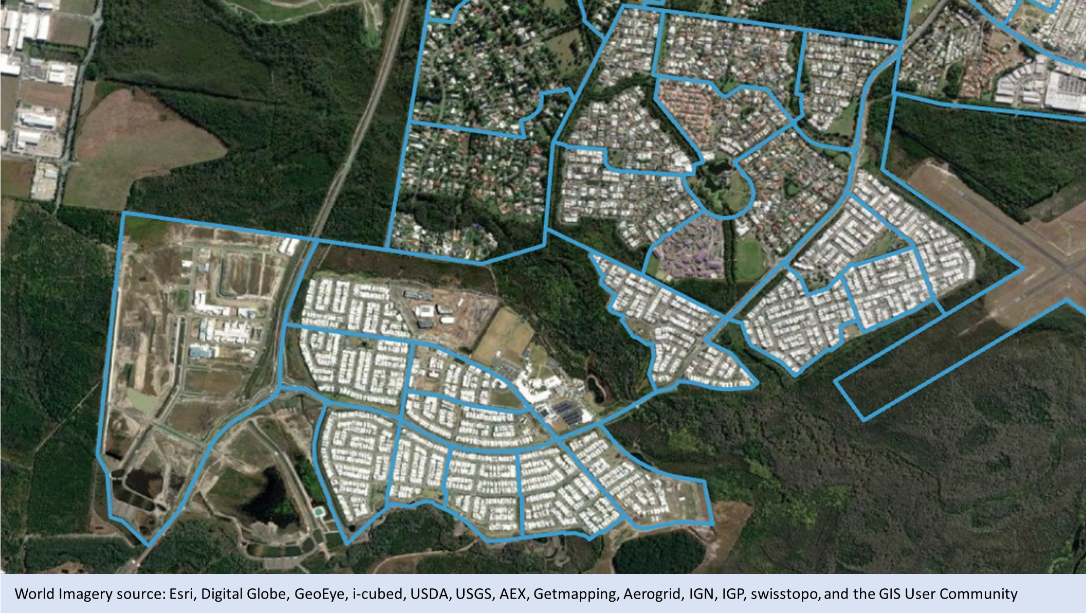
In accordance with these principles most of the change in ASGS Edition 3 is the result of simple splits. Figures 4a and 4b show an example of one large Mesh Block that was split into 176 smaller Mesh Blocks. This kind of design is typical for growth areas on the edge of large cities. Figures 5a and 5b show a similar design process where two large SA2s have been split into 6 smaller SA2s.
Figure 4a - 2016 Mesh Blocks in Mickleham - Yuroke
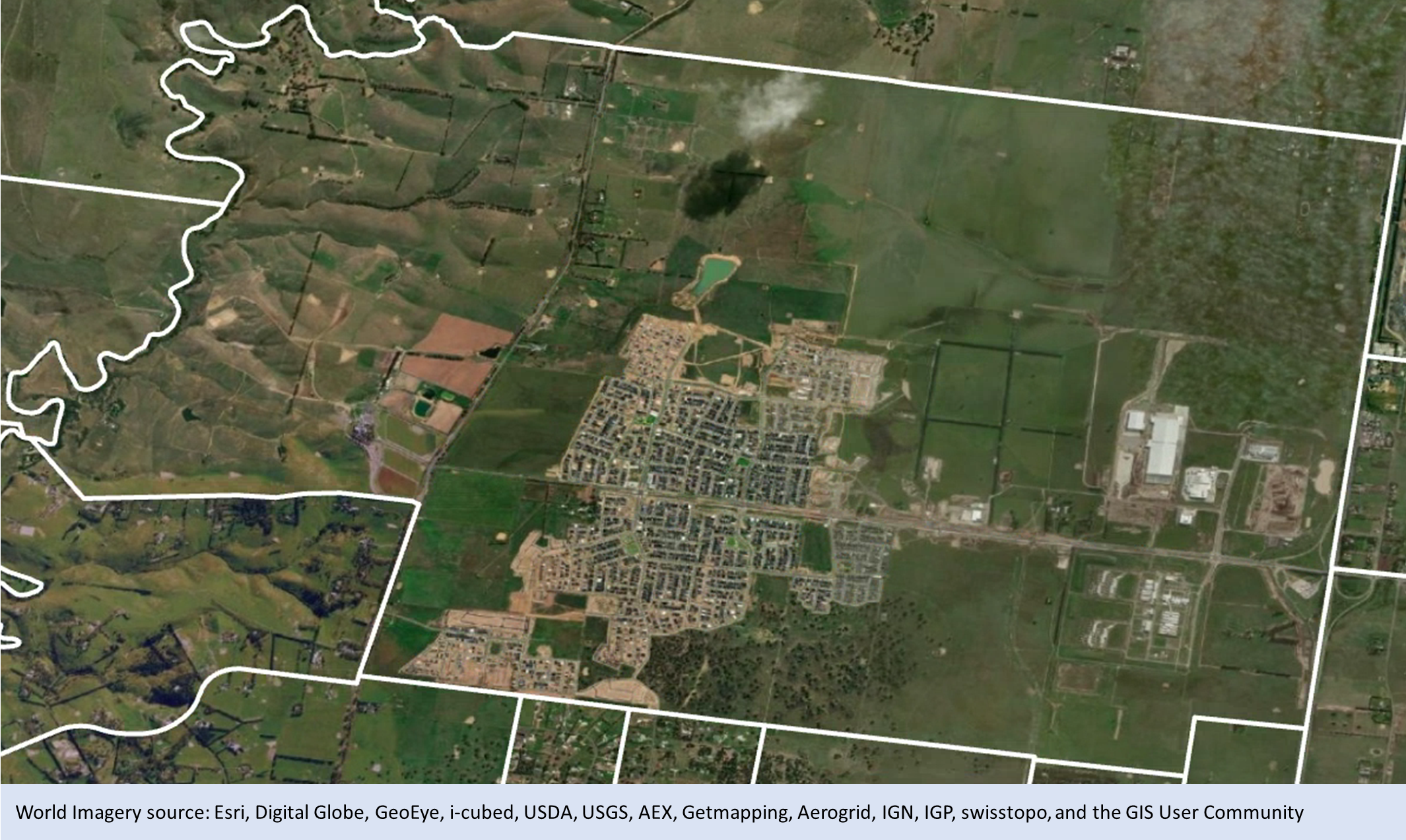
Figure 4b - Edition 3 (2021) Mesh Blocks in Mickleham - Yuroke
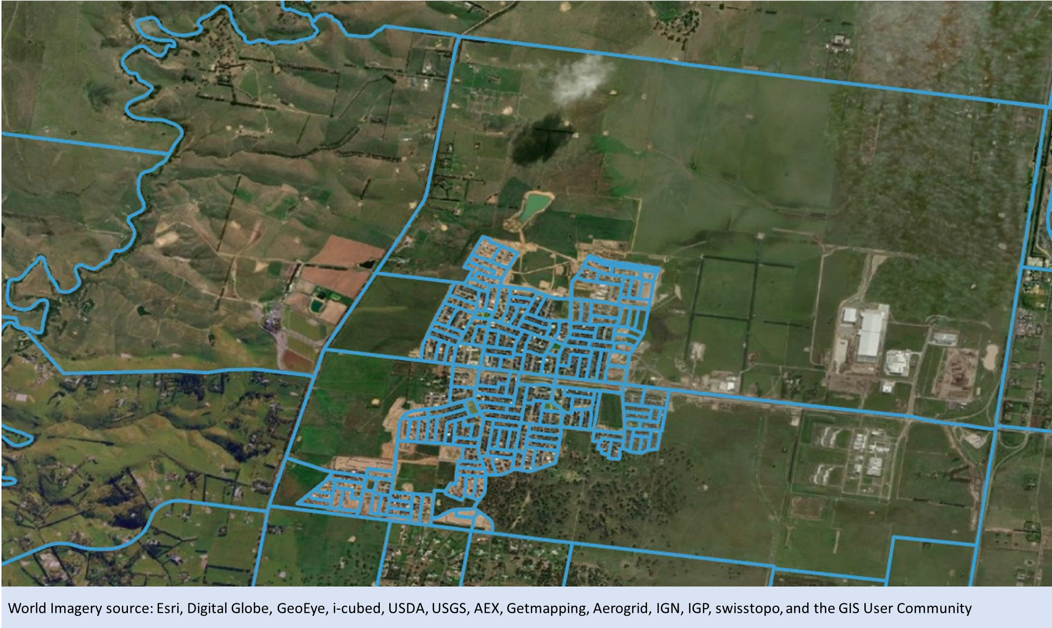
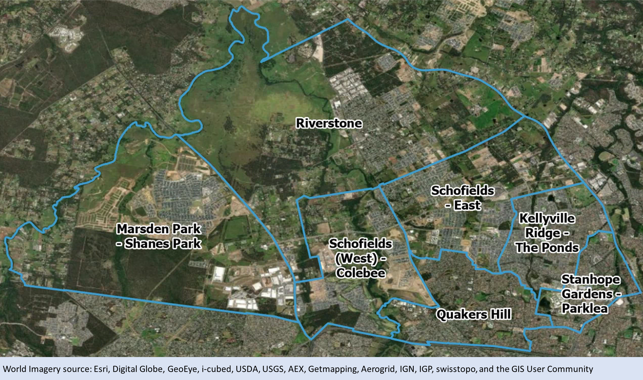
Figure 5a - 2016 SA2s in Riverstone - Marsden Park (NSW)
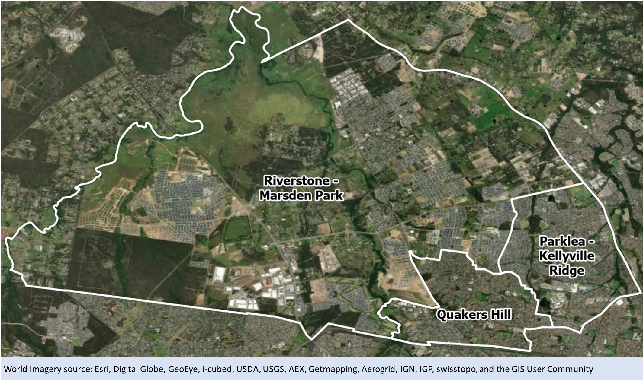
Figure 5b - Edition 3 (2021) SA2s in Riverstone - Marsden Park (NSW)
Merges
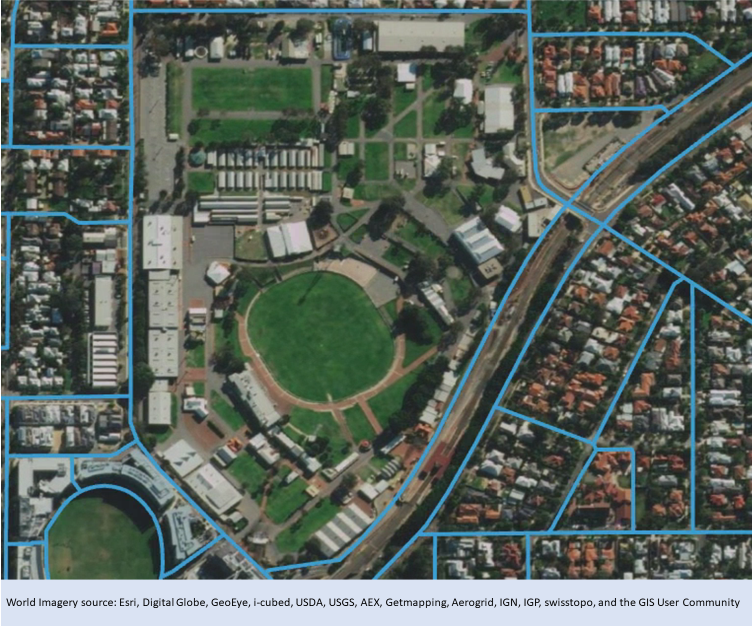
Merges were minimised in ASGS Edition 3. Where necessary, boundaries were merged to avoid cutting through existing infrastructure or a new growth area. Figures 6a and 6b show an example of two Mesh Blocks that have been merged together to ensure two halves of a showground can be address coded more accurately.
Figure 6a - 2016 Mesh Blocks in Claremont (WA)
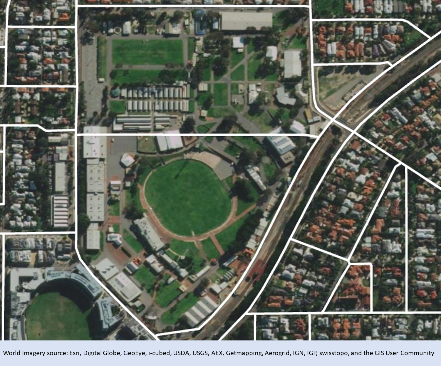
Figure 6b - 2021 Mesh Block in Claremont (WA)
Redesign
In some circumstances, simple splits and merges are not enough to account for growth and change on the ground. Where 2016 boundaries had to be both merged and split, areas are considered ‘redesigned’. This typically occurs in high growth areas where old features on the ground have been replaced by new development.
Figures 7a and 7b show an example of SA1 redesign on the edge of Caloundra on the Sunshine Coast. The 2016 SA1 boundary followed an old suburb boundary which has since been revised to accommodate new housing developments. The original areas were merged and then split into new SA1s. Redesigning boundaries in this way has minimal effect on the comparability of data over time as in previous editions of the ASGS, growth areas generally contained little or no population.
Figure 7a - 2016 SA1s in Caloundra
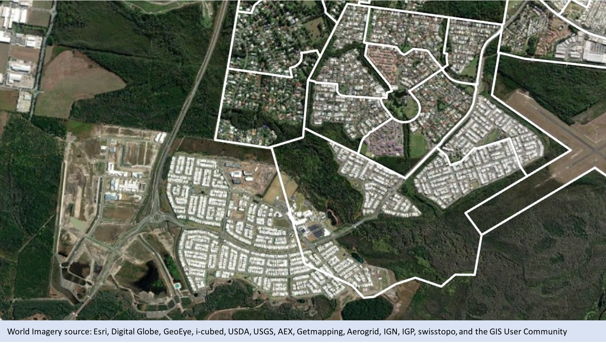
Figure 7b - Edition 3 (2021) SA1s in Caloundra
Alignment
Alignment refers to small area changes that do not affect population. This type of change will be evident in area based correspondences between ASGS Edition 3 and other ASGS editions, but will not affect population based correspondences. Unlike other boundary changes, alignment does not trigger a code change.
In this edition the most significant alignment occurred along state and territory borders. All Mesh Blocks next to state borders were aligned to the official state land borders released by Geoscience Australia in 2020. These official state land borders are endorsed by the Surveyors General of each state and territory, the Spatial Information Council (ANZLIC) and the Intergovernmental Committee on Surveying and Mapping (ICSM). These changes will help ensure geospatial comparability to other State and Federal Government datasets. Future updates to state borders and the coastline, as agreed by the Surveyors General, ANZLIC and ICSM, will be adopted where applicable in future editions of the ASGS.
Changes to ASGS codes
The codes and names associated with statistical areas change when an area is split, merged, or redesigned.
Changes in higher level statistical areas also result in code changes to the lower level regions contained within, except for Mesh Blocks as these are the building blocks. The smaller area may also be split, merged, redesigned, or may remain unchanged. This is due to the hierarchical coding system.
Alignment changes do not result in code or name changes at any level.
For more information on the ASGS code changes please refer to the tables below in the list of changes section.
Identifying change
The ABS provides several resources to help users understand changes to boundaries and codes, and to help them manage the transformation of data across different ASGS editions and other geographies. These resources include ABS Maps, various correspondences and the list of changes section.
In ASGS Edition 3, change flags have been included on all Main Structure and Greater Capital City Statistical boundaries as an attribute. This attribute informs users whether an area has changed since ASGS 2016 and what the nature of that change is.
| CHANGE_FLAG_2021 | CHANGE_LABEL_2021 | Description |
|---|---|---|
| 0 | No change | Boundary remains the same as 2016. Code and name (if applicable) remain the same. Some of these areas will have minor alignment adjustments. They have been recorded as no change because no population has been affected and the primary land use has also been maintained. |
| 1 | New | A new, or redesigned, area for ASGS for Edition 3. This feature has a new code and name (where applicable). In some instances with significant SA2 change, the 2016 name is maintained as it continues to accurately describe the area or locality. To understand changes at the SA2 level, both codes and names should always be used together. |
| 2 | Code change | The Edition 3 code has changed due to a code change at a higher level of the ASGS. However, there has been no change to the boundary and direct comparison can be made with ASGS 2016. |
| 3 | Name change | An Edition 3 (2021) area has been re-named to reflect the local area it represents and/or fix name and spelling errors. In these cases, no code change has occurred. There has also been no change to the boundary. |
List of changes
| SA3 Label changes | |
|---|---|
| From (2016): | To (Edition 3): |
| 80111 Urriarra - Namadgi | 80111 Uriarra - Namadgi |
| SA2 splits | |
|---|---|
| From (2016): | To (Edition 3): |
| 101021011 Queanbeyan Region | 101021610 Googong |
| 101021611 Queanbeyan Surrounds | |
| 103011058 Bathurst | 103011612 Bathurst - South |
| 103011613 Bathurst - West | |
| 106021117 Maitland - West | 106021615 Rutherford (North) - Aberglasslyn |
| 106021616 Rutherford (South) - Telarah | |
| 108041163 Port Macquarie - East | 108041619 Port Macquarie - East |
| 108041620 Port Macquarie - South | |
| 116021310 Parklea - Kellyville Ridge | 116021628 Kellyville Ridge - The Ponds |
| 116021633 Stanhope Gardens - Parklea | |
| 116021312 Riverstone - Marsden Park | 116021629 Marsden Park - Shanes Park |
| 116021632 Schofields - East | |
| 116021630 Riverstone | |
| 116021631 Schofields (West) - Colebee | |
| 117011322 Mascot - Eastlakes | 117011634 Eastlakes |
| 117011635 Mascot | |
| 117021326 Marrickville | 117021637 Marrickville - South |
| 117021636 Marrickville - North | |
| 117031332 Newtown - Camperdown - Darlington | 117031640 Newtown (NSW) |
| 117031638 Camperdown - Darlington | |
| 117031334 Pyrmont - Ultimo | 117031641 Pyrmont |
| 117031646 Ultimo | |
| 117031335 Redfern - Chippendale | 117031642 Redfern |
| 117031639 Chippendale | |
| 117031337 Sydney - Haymarket - The Rocks | 117031645 Sydney (South) - Haymarket |
| 117031644 Sydney (North) - Millers Point | |
| 117031338 Waterloo - Beaconsfield | 117031643 Rosebery - Beaconsfield |
| 117031648 Zetland | |
| 117031647 Waterloo | |
| 118011343 Double Bay - Bellevue Hill | 118011649 Bellevue Hill |
| 118011650 Double Bay - Darling Point | |
| 118021348 Coogee - Clovelly | 118021654 South Coogee |
| 118021651 Coogee - Clovelly | |
| 118021350 Malabar - La Perouse - Chifley | 118021653 Matraville - Chifley |
| 118021652 Malabar - La Perouse | |
| 119011357 Greenacre - Mount Lewis | 119011655 Greenacre - North |
| 119011656 Greenacre - South | |
| 119011359 Panania - Milperra - Picnic Point | 119011657 Panania (North) - Milperra |
| 119011658 Panania (South) - Picnic Point | |
| 119021363 Canterbury (South) - Campsie | 119021661 Canterbury - South |
| 119021659 Campsie - North | |
| 119021660 Campsie - South | |
| 119021364 Kingsgrove (North) - Earlwood | 119021663 Kingsgrove - North |
| 119021662 Earlwood | |
| 119031368 Hurstville | 119031664 Hurstville - Central |
| 119031665 Hurstville - North | |
| 119031369 Mortdale - Penshurst | 119031666 Mortdale - Oatley |
| 119031667 Penshurst | |
| 119041375 Arncliffe - Bardwell Valley | 119041668 Arncliffe - Bardwell Valley |
| 119041671 Wolli Creek | |
| 119041376 Bexley | 119041670 Bexley - South |
| 119041669 Bexley - North | |
| 120011384 Concord West - North Strathfield | 120011673 Rhodes |
| 120011672 Concord West - North Strathfield | |
| 120021388 Leichhardt - Annandale | 120021674 Annandale (NSW) |
| 120021675 Leichhardt | |
| 120031390 Ashfield | 120031677 Ashfield - South |
| 120031676 Ashfield - North | |
| 120031391 Burwood - Croydon | 120031679 Croydon |
| 120031678 Burwood (NSW) | |
| 120031575 Strathfield | 120031681 Strathfield - West |
| 120031680 Strathfield - East | |
| 121011398 Chatswood (East) - Artarmon | 121011684 Chatswood - East |
| 121011682 Artarmon | |
| 121011400 Lane Cove - Greenwich | 121011686 Lane Cove |
| 121011685 Greenwich - Riverview | |
| 121011402 Willoughby - Castle Cove - Northbridge | 121011683 Castle Cove - Northbridge |
| 121011687 Willoughby | |
| 121041415 Mosman | 121041689 Mosman - South |
| 121041688 Mosman - North | |
| 122021423 Warriewood - Mona Vale | 122021691 North Narrabeen - Warriewood (South) |
| 122021690 Mona Vale - Warriewood (North) | |
| 122031426 Dee Why - North Curl Curl | 122031695 Dee Why - North |
| 122031694 Dee Why (South) - North Curl Curl | |
| 122031428 Frenchs Forest - Belrose | 122031696 Frenchs Forest - Oxford Falls |
| 122031692 Belrose | |
| 122031431 Narrabeen - Collaroy | 122031693 Collaroy - Collaroy Plateau |
| 122031697 Narrabeen - Wheeler Heights | |
| 123011434 Elderslie - Harrington Park | 123011700 Harrington Park |
| 123011699 Elderslie - Narellan | |
| 123011435 Mount Annan - Currans Hill | 123011701 Mount Annan |
| 123011702 Spring Farm | |
| 123011698 Currans Hill | |
| 123021442 Macquarie Fields - Glenfield | 123021704 Glenfield |
| 123021706 Macquarie Fields | |
| 124031458 Castlereagh - Cranebrook | 124031708 Jordan Springs - Llandilo |
| 124031707 Cranebrook - Castlereagh | |
| 125011473 Homebush Bay - Silverwater | 125011710 Wentworth Point - Sydney Olympic Park |
| 125011709 Silverwater - Newington | |
| 125021476 Carlingford | 125021712 Carlingford - West |
| 125021711 Carlingford - East | |
| 125031485 Merrylands - Holroyd | 125031714 Merrylands - Holroyd |
| 125031716 South Wentworthville | |
| 125041492 Parramatta - Rosehill | 125041717 Parramatta - North |
| 125041718 Parramatta - South | |
| 125041719 Rosehill - Harris Park | |
| 126011495 Epping - North Epping | 126011720 Epping (East) - North Epping |
| 126011721 Epping (NSW) - West | |
| 126021497 Eastwood - Denistone | 126021722 Denistone |
| 126021723 Eastwood | |
| 126021591 Ryde | 126021724 Ryde - North |
| 126021725 Ryde - South | |
| 127031598 Liverpool | 127031731 Liverpool - East |
| 127031732 Liverpool - West | |
| 201011003 Ballarat - North | 201011481 Ballarat East - Warrenheip |
| 201011482 Ballarat North - Invermay | |
| 201011004 Ballarat - South | 201011483 Canadian - Mount Clear |
| 201011484 Sebastopol - Redan | |
| 203021038 Corio - Norlane | 203021486 Corio - Lovely Banks |
| 203021488 Norlane | |
| 203021041 Grovedale | 203021485 Charlemont |
| 203021487 Grovedale - Mount Duneed | |
| 203031050 Ocean Grove - Barwon Heads | 203031489 Barwon Heads - Armstrong Creek |
| 203031490 Ocean Grove | |
| 204031074 Wodonga | 204031491 Baranduda - Leneva |
| 204031492 Wodonga | |
| 205041097 Traralgon | 205041493 Traralgon - East |
| 205041494 Traralgon - West | |
| 206011105 Brunswick | 206011495 Brunswick - North |
| 206011496 Brunswick - South | |
| 206011108 Coburg | 206011497 Coburg - East |
| 206011498 Coburg - West | |
| 206021111 Northcote | 206021499 Northcote - East |
| 206021500 Northcote - West | |
| 206031114 Essendon - Aberfeldie | 206031501 Essendon (West) - Aberfeldie |
| 206031502 Essendon - East | |
| 206041122 Melbourne | 206041503 Melbourne CBD - East |
| 206041504 Melbourne CBD - North | |
| 206041505 Melbourne CBD - West | |
| 206041123 North Melbourne | 206041506 North Melbourne |
| 206041510 West Melbourne - Residential | |
| 206051133 St Kilda | 206051513 St Kilda - Central |
| 206051514 St Kilda - West | |
| 206061137 South Yarra - East | 206061515 South Yarra - North |
| 206061516 South Yarra - South | |
| 206071144 Richmond (Vic.) | 206071517 Richmond (South) - Cremorne |
| 206071518 Richmond - North | |
| 207011151 Hawthorn | 207011519 Hawthorn - North |
| 207011520 Hawthorn - South | |
| 207011153 Kew | 207011521 Kew - South |
| 207011522 Kew - West | |
| 209021207 Reservoir - East | 209021523 Reservoir - North East |
| 209021525 Reservoir - South East | |
| 209021208 Reservoir - West | 209021524 Reservoir - North West |
| 209021526 Reservoir - South West | |
| 209041219 Lalor | 209041529 Lalor - East |
| 209041530 Lalor - West | |
| 209041430 Doreen | 209041527 Doreen - North |
| 209041528 Doreen - South | |
| 209041434 Mernda | 209041531 Mernda - North |
| 209041532 Mernda - South | |
| 210011229 Keilor East | 210011533 Avondale Heights |
| 210011534 Keilor East | |
| 210031239 Pascoe Vale | 210031537 Oak Park |
| 210031538 Pascoe Vale | |
| 210031438 Glenroy | 210031535 Glenroy - East |
| 210031536 Glenroy - West | |
| 210041241 Sunbury - South | 210041539 Diggers Rest |
| 210041540 Sunbury - South | |
| 210041541 Sunbury - West | |
| 210051249 Roxburgh Park - Somerton | 210051544 Roxburgh Park (South) - Somerton |
| 210051545 Roxburgh Park - North | |
| 212021294 Berwick - South | 212021553 Berwick - South East |
| 212021554 Berwick - South West | |
| 212031301 Cranbourne East | 212031555 Clyde North - North |
| 212031556 Clyde North - South | |
| 212031557 Cranbourne East - North | |
| 212031558 Cranbourne East - South | |
| 212031302 Cranbourne North | 212031559 Cranbourne North - East |
| 212031560 Cranbourne North - West | |
| 212031305 Hampton Park - Lynbrook | 212031561 Hampton Park - East |
| 212031562 Hampton Park - West | |
| 212041311 Dandenong | 212041563 Dandenong - North |
| 212041564 Dandenong - South | |
| 212041314 Keysborough | 212041565 Keysborough - North |
| 212041566 Keysborough - South | |
| 212051320 Clayton | 212051567 Clayton (North) - Notting Hill |
| 212051568 Clayton - Central | |
| 213011330 Deer Park - Derrimut | 213011569 Deer Park |
| 213011570 Derrimut | |
| 213041355 Hillside | 213041574 Fraser Rise - Plumpton |
| 213041575 Hillside | |
| 213041356 Melton | 213041576 Kurunjang - Toolern Vale |
| 213041577 Melton | |
| 213041357 Melton South | 213041571 Brookfield |
| 213041572 Cobblebank - Strathtulloh | |
| 213041573 Eynesbury - Exford | |
| 213041578 Melton South - Weir Views | |
| 213051365 Tarneit | 213051582 Tarneit (West) - Mount Cottrell |
| 213051583 Tarneit - Central | |
| 213051584 Tarneit - North | |
| 213051585 Tarneit - South | |
| 213051366 Truganina | 213051586 Truganina - North |
| 213051587 Truganina - South East | |
| 213051588 Truganina - South West | |
| 213051369 Wyndham Vale | 213051579 Manor Lakes - Quandong |
| 213051589 Wyndham Vale - North | |
| 213051590 Wyndham Vale - South | |
| 213051465 Point Cook - North | 213051580 Point Cook - North East |
| 213051581 Point Cook - North West | |
| 214021380 Mornington | 214021591 Mornington - East |
| 214021592 Mornington - West | |
| 216031417 Shepparton - South | 216031593 Kialla |
| 216031594 Shepparton - South East | |
| 301021527 Redland Islands | 301021550 North Stradbroke Island |
| 301021551 Southern Moreton Bay Islands | |
| 309071255 Ormeau - Yatala | 309071552 Ormeau (East) - Stapylton |
| 309071553 Ormeau (West) - Yatala | |
| 309081261 Robina | 309081559 Robina - East |
| 309081560 Robina - West | |
| 309101270 Surfers Paradise | 309101561 Surfers Paradise - North |
| 309101562 Surfers Paradise - South | |
| 310011273 Forest Lake - Doolandella | 310011563 Doolandella |
| 310011564 Forest Lake - Ellen Grove | |
| 310041296 Bellbird Park - Brookwater | 310041565 Augustine Heights - Brookwater |
| 310041566 Bellbird Park | |
| 311041320 Greenbank | 311041568 Flagstone (West) - New Beith |
| 311041569 Greenbank - North Maclean | |
| 311041321 Jimboomba | 311041567 Flagstone (East) - Riverbend |
| 311041570 Jimboomba - Glenlogan | |
| 311041571 Yarrabilba | |
| 313021365 Caboolture | 313021572 Caboolture - East |
| 313021573 Caboolture - West | |
| 313051542 Scarborough - Newport - Moreton Island | 313051574 Moreton Island |
| 313051575 Scarborough - Newport | |
| 314021388 Dakabin - Kallangur | 314021576 Dakabin |
| 314021577 Kallangur | |
| 314021390 North Lakes - Mango Hill | 314021578 Mango Hill |
| 314021579 North Lakes | |
| 318021473 Deeragun | 318021582 Burdell - Mount Low |
| 318021583 Deeragun - Jensen | |
| 402031037 Northgate - Oakden - Gilles Plains | 402031175 Northgate - Northfield |
| 402031176 Valley View - Gilles Plains | |
| 403041087 Seaford (SA) | 403041177 Seaford - Seaford Meadows |
| 403041178 Seaford Rise - Moana | |
| 501011002 Busselton | 501011293 Busselton - East |
| 501011294 Busselton - West | |
| 503021041 Perth City | 503021295 East Perth |
| 503021296 Perth (North) - Highgate | |
| 503021297 Perth (West) - Northbridge | |
| 504031059 Ellenbrook | 504031298 Aveley |
| 504031299 Brabham - Henley Brook | |
| 504031300 Ellenbrook | |
| 505021086 Dianella | 505021301 Dianella - North |
| 505021302 Dianella - South | |
| 505031103 Madeley - Darch - Landsdale | 505031304 Landsdale |
| 505031305 Madeley - Darch | |
| 505031108 Wanneroo | 505031303 Hocking - Pearsall |
| 505031306 Wanneroo - Sinagra | |
| 506011113 Forrestdale - Harrisdale - Piara Waters | 506011307 Harrisdale |
| 506011308 Piara Waters - Forrestdale | |
| 506021122 Rivervale - Kewdale - Cloverdale | 506021309 Cloverdale |
| 506021310 Kewdale | |
| 506021311 Rivervale | |
| 507051185 Baldivis | 507051312 Baldivis - North |
| 507051313 Baldivis - South | |
| 507051314 Karnup | |
| 801011112 West Belconnen | 801011142 Macnamara |
| 801011143 Strathnairn | |
| 801011144 West Belconnen | |
| 801101138 Molonglo - North | 801101145 Molonglo - East |
| 801101146 Whitlam | |
| SA2 redesign | |
|---|---|
| From (2016): | To (Edition 3): |
| 106021115 Maitland - East | 106021614 East Maitland - Metford |
| 106021617 Tenambit - East Maitland | |
| 106021118 Thornton - Millers Forest | 106021618 Thornton - Millers Forest |
| 115011559 Kellyville | 115011621 Kellyville - East |
| 115011622 Kellyville - West | |
| 115041302 Rouse Hill - Beaumont Hills | 115041623 Box Hill - Nelson |
| 115041624 North Kellyville | |
| 115041625 Rouse Hill - Beaumont Hills | |
| 116011308 Seven Hills - Toongabbie | 116011626 Seven Hills - Prospect |
| 116011627 Toongabbie - West | |
| 123021440 Ingleburn - Denham Court | 123021703 Denham Court - Bardia |
| 123021705 Ingleburn | |
| 125031482 Greystanes - Pemulwuy | 125031713 Greystanes - South |
| 125031715 Pemulwuy - Greystanes (North) | |
| 127011506 Cobbitty - Leppington | 127011726 Cobbitty - Bringelly |
| 127011727 Gledswood Hills - Gregory Hills | |
| 127011728 Leppington - Catherine Field | |
| 127011729 Oran Park | |
| 127031600 Prestons - Edmondson Park | 127031730 Edmondson Park |
| 127031733 Prestons | |
| 206041126 Southbank | 206041507 Royal Botanic Gardens Victoria |
| 206041508 Southbank (West) - South Wharf | |
| 206041509 Southbank - East | |
| 206051131 Port Melbourne Industrial | 206051511 Port Melbourne Industrial |
| 206051132 South Melbourne | 206051512 South Melbourne |
| 210051444 Craigieburn - West | 210051542 Craigieburn - North West |
| 210051543 Craigieburn - West | |
| 212011287 Beaconsfield - Officer | 212011546 Beaconsfield - Officer |
| 212011288 Bunyip - Garfield | 212011547 Bunyip - Garfield |
| 212011290 Koo Wee Rup | 212011548 Koo Wee Rup |
| 212011291 Pakenham - North | 212011549 Pakenham - North East |
| 212011550 Pakenham - North West | |
| 212011551 Pakenham - South East | |
| 212011552 Pakenham - South West | |
| 309071257 Pimpama | 309071554 Pimpama - North |
| 309071555 Pimpama - South | |
| 309071258 Upper Coomera - Willow Vale | 309071556 Upper Coomera (South) - Wongawallan |
| 309071557 Upper Coomera - North | |
| 309071558 Willow Vale - Pimpama (West) | |
| 316021420 Caloundra - West | 316021580 Caloundra West - Baringa |
| 316021581 Meridan Plains - Little Mountain (North) | |
| SA2 label change | |
|---|---|
| From (2016): | To (Edition 3): |
| 101031015 Cooma Region | 101031015 Cooma Surrounds |
| 101051540 Goulburn Region | 101051540 Goulburn Surrounds |
| 101061542 Yass Region | 101061542 Yass Surrounds |
| 101061544 Young Region | 101061544 Young Surrounds |
| 103011060 Bathurst Region | 103011060 Bathurst Surrounds |
| 103021064 Cowra Region | 103021064 Cowra Surrounds |
| 103021068 Parkes Region | 103021068 Parkes Surrounds |
| 103031071 Lithgow Region | 103031071 Lithgow Surrounds |
| 103031073 Mudgee Region - East | 103031073 Mudgee Surrounds - East |
| 103031074 Mudgee Region - West | 103031074 Mudgee Surrounds - West |
| 103041079 Orange Region | 103041079 Orange Surrounds |
| 104011081 Grafton Region | 104011081 Grafton Surrounds |
| 105031103 Dubbo Region | 105031103 Dubbo Surrounds |
| 106011109 Cessnock Region | 106011109 Cessnock Surrounds |
| 106011113 Singleton Region | 106011113 Singleton Surrounds |
| 106041127 Muswellbrook Region | 106041127 Muswellbrook Surrounds |
| 106041129 Scone Region | 106041129 Scone Surrounds |
| 108011153 Forster-Tuncurry Region | 108011153 Forster-Tuncurry Surrounds |
| 108021156 Kempsey Region | 108021156 Kempsey Surrounds |
| 108021159 Nambucca Heads Region | 108021159 Nambucca Heads Surrounds |
| 108041165 Port Macquarie Region | 108041165 Port Macquarie Surrounds |
| 108051170 Taree Region | 108051170 Taree Surrounds |
| 109011175 Albury Region | 109011175 Albury Surrounds |
| 109031181 Corowa Region | 109031181 Corowa Surrounds |
| 109031183 Deniliquin Region | 109031183 Deniliquin Surrounds |
| 110011187 Armidale Region - North | 110011187 Armidale Surrounds - North |
| 110011188 Armidale Region - South | 110011188 Armidale Surrounds - South |
| 110021192 Inverell Region - East | 110021192 Inverell Surrounds - East |
| 110021193 Inverell Region - West | 110021193 Inverell Surrounds - West |
| 110031196 Moree Region | 110031196 Moree Surrounds |
| 110031198 Narrabri Region | 110031198 Narrabri Surrounds |
| 110041200 Gunnedah Region | 110041200 Gunnedah Surrounds |
| 110041205 Tamworth Region | 110041205 Tamworth Surrounds |
| 112011237 Ballina Region | 112011237 Ballina Surrounds |
| 112021245 Casino Region | 112021245 Casino Surrounds |
| 112021249 Lismore Region | 112021249 Lismore Surrounds |
| 112031252 Murwillumbah Region | 112031252 Murwillumbah Surrounds |
| 112031551 Terranora - North Tumblegum | 112031551 Terranora - North Tumbulgum |
| 113011257 Griffith Region | 113011257 Griffith Surrounds |
| 113021262 Tumut Region | 113021262 Tumut Surrounds |
| 113031271 Wagga Wagga Region | 113031271 Wagga Wagga Surrounds |
| 114011283 Ulladulla Region | 114011283 Ulladulla Surrounds |
| 115011290 Baulkham Hills (East) | 115011290 Baulkham Hills - East |
| 116011560 Blacktown (South) | 116011560 Blacktown - South |
| 116011561 Blacktown (West) | 116011561 Blacktown - West |
| 121021579 Waitara - Wahroonga (West) | 121021579 Wahroonga (West) - Waitara |
| 128011606 Woolaware - Burraneer | 128011606 Woolooware - Burraneer |
| 201021009 Bacchus Marsh Region | 201021009 Bacchus Marsh Surrounds |
| 201031017 Maryborough Region | 201031017 Maryborough Surrounds |
| 202021026 Bendigo Region - South | 202021026 Bendigo Surrounds - South |
| 202021028 Castlemaine Region | 202021028 Castlemaine Surrounds |
| 202031032 Bendigo Region - North | 202031032 Bendigo Surrounds - North |
| 204011060 Seymour Region | 204011060 Seymour Surrounds |
| 204021064 Benalla Region | 204021064 Benalla Surrounds |
| 204021067 Wangaratta Region | 204021067 Wangaratta Surrounds |
| 206041127 West Melbourne | 206041127 West Melbourne - Industrial |
| 206071145 Yarra - North | 206071145 Clifton Hill - Alphington |
| 207021424 Doncaster East (North) | 207021424 Doncaster East - North |
| 207021425 Doncaster East (South) | 207021425 Doncaster East - South |
| 207031165 Burwood | 207031165 Burwood (Vic.) |
| 208011171 Cheltenham - Highett (West) | 208011171 Highett (West) - Cheltenham |
| 208021426 Bentleigh East (North) | 208021426 Bentleigh East - North |
| 208021427 Bentleigh East (South) | 208021427 Bentleigh East - South |
| 208031188 Cheltenham - Highett (East) | 208031188 Highett (East) - Cheltenham |
| 209041433 Epping - West | 209041433 Epping (Vic.) - West |
| 209041435 South Morang (North) | 209041435 South Morang - North |
| 209041436 South Morang (South) | 209041436 South Morang - South |
| 211011447 Ferntree Gully (North) | 211011447 Ferntree Gully - North |
| 212031457 Narre Warren South (East) | 212031457 Narre Warren South - East |
| 212031458 Narre Warren South (West) | 212031458 Narre Warren South - West |
| 215011387 Ararat Region | 215011387 Ararat Surrounds |
| 215011389 Horsham Region | 215011389 Horsham Surrounds |
| 215021398 Mildura Region | 215021398 Mildura Surrounds |
| 215031405 Swan Hill Region | 215031405 Swan Hill Surrounds |
| 216031418 Shepparton Region - East | 216031418 Shepparton Surrounds - East |
| 216031419 Shepparton Region - West | 216031419 Shepparton Surrounds - West |
| 217031473 Colac Region | 217031473 Colac Surrounds |
| 307011177 Roma Region | 307011177 Roma Surrounds |
| 307031188 Stanthorpe Region | 307031188 Stanthorpe Surrounds |
| 308031218 Rockhampton Region - East | 308031218 Rockhampton Surrounds - East |
| 308031219 Rockhampton Region - North | 308031219 Rockhampton Surrounds - North |
| 308031220 Rockhampton Region - West | 308031220 Rockhampton Surrounds - West |
| 311061330 Kingston (Qld.) | 311061330 Kingston (Qld) |
| 318011465 Ingham Region | 318011465 Ingham Surrounds |
| 318021468 Annandale | 318021468 Annandale (Qld) |
| 319011498 Bundaberg Region - North | 319011498 Bundaberg Surrounds - North |
| 319011499 Bundaberg Region - South | 319011499 Bundaberg Surrounds - South |
| 319021506 Kingaroy Region - North | 319021506 Kingaroy Surrounds - North |
| 319021507 Kingaroy Region - South | 319021507 Kingaroy Surrounds - South |
| 319031514 Gympie Region | 319031514 Gympie Surrounds |
| 319051525 Maryborough Region - South | 319051525 Maryborough Surrounds - South |
| 401021008 Mount Barker Region | 401021008 Mount Barker Surrounds |
| 401031012 Glenside - Beaumont | 401031012 Beaumont - Glen Osmond |
| 405031123 Port Pirie Region | 405031123 Port Pirie Surrounds |
| 407011147 Strathalbyn Region | 407011147 Strathalbyn Surrounds |
| 407021155 Naracoorte Region | 407021155 Naracoorte Surrounds |
| 407031163 Loxton Region | 407031163 Loxton Surrounds |
| 407031166 Murray Bridge Region | 407031166 Murray Bridge Surrounds |
| 407031168 Renmark Region | 407031168 Renmark Surrounds |
| 501011003 Busselton Region | 501011003 Busselton Surrounds |
| 507031169 Bertram - Wellard (West) | 507031169 Wellard (West) - Bertram |
| 509011226 Albany Region | 509011226 Albany Surrounds |
| 511011275 Esperance Region | 511011275 Esperance Surrounds |
| 604011076 Burnie - Ulverstone Region | 604011076 Burnie - Ulverstone Surrounds |