Latest release

Remoteness Structure

Australian Statistical Geography Standard (ASGS) Edition 3
Reference period
July 2021 - June 2026

The Australian Statistical Geography Standard (ASGS) Remoteness Structure defines Remoteness Areas for the purpose of releasing and analysing statistics.

Remoteness Areas are derived from the Accessibility/Remoteness Index of Australia Plus (ARIA+) produced by the University of Adelaide.

Remoteness Areas divide Australia into five classes of remoteness on the basis of a measure of relative access to services. The five remoteness classes are: Major Cities, Inner Regional, Outer Regional, Remote and Very Remote.

For information on how the Remoteness Structure relates to other ASGS structures refer to the ASGS diagram.

Remoteness Areas

The Remoteness Structure defines Remoteness Areas for the purpose of releasing and analysing statistics. Remoteness Areas (RA) divide Australia into five classes of remoteness which are characterised by a measure of relative geographic access to services. Access to services is measured using the Accessibility/Remoteness Index of Australia Plus (ARIA+), produced by the Australian Centre for Housing Research (formerly the Hugo Centre for Population and Migration Studies) at the University of Adelaide. 


A map of ASGS Edition 3 Remoteness Areas is shown below. Users can examine the current and past Remoteness Area geography in more detail using ABS Maps.

Map of ASGS Edition 3 Remoteness Areas for Australia

Map detailing the five different Remoteness Area classes. The map shows areas shaded in light to dark green colours, to demonstrate Very Remote Australia, Remote Australia, Outer Regional Australia, Inner Regional Australia and Major Cities of Australia respectively.

Map detailing the five different Remoteness Area classes which make up the Remoteness Structure. The map shows areas shaded in light to dark green colours, to demonstrate Very Remote Australia, Remote Australia, Outer Regional Australia, Inner Regional Australia and Major Cities of Australia respectively.

Remoteness Structure files, including downloadable digital boundaries, data services or web services, correspondences, and allocation files (i.e. other ASGS boundaries that aggregate to form Remoteness Areas) are available in the Access and downloads tab.

The ABS encourages the use of the ASGS by other organisations to improve the comparability and integration of statistical and other data on a common geographic basis. 

RA design criteria

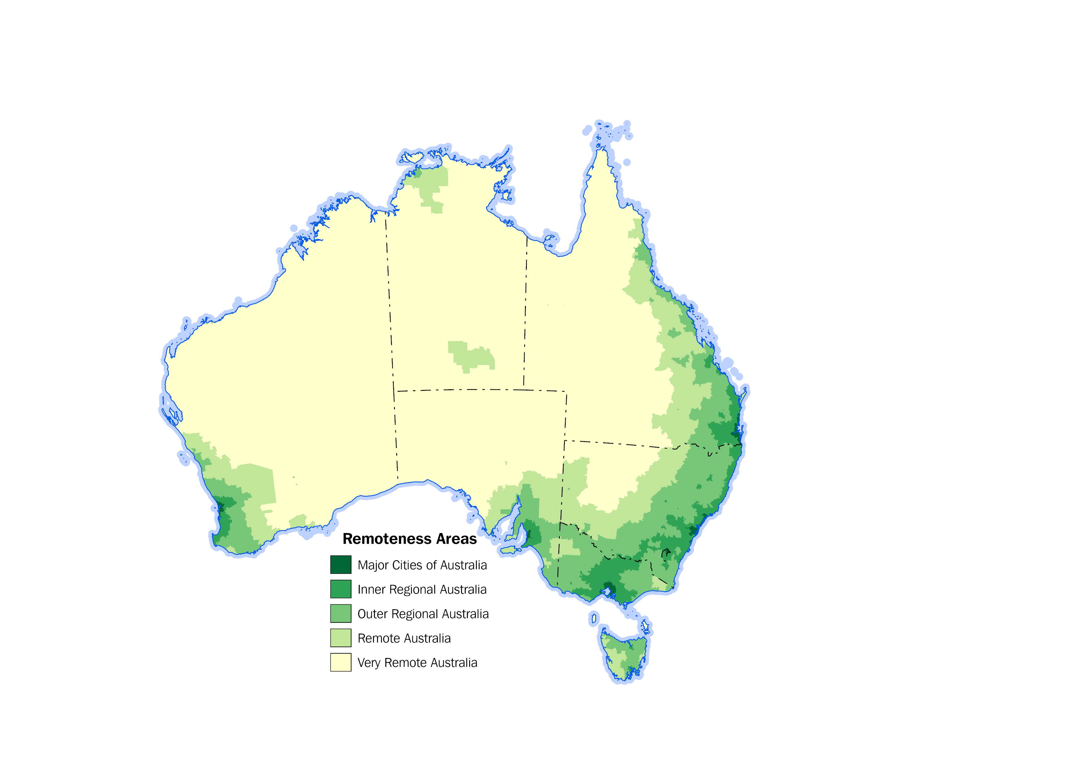
The Australian Statistical Geography Standard (ASGS) Remoteness Structure defines 5 classes of relative geographic remoteness across Australia. These 5 classes are:

  • Major Cities of Australia
  • Inner Regional Australia
  • Outer Regional Australia
  • Remote Australia
  • Very Remote Australia

Relative geographic remoteness is measured in an objective way using the Accessibility/Remoteness Index of Australia Plus (ARIA+).

ARIA+ is derived by measuring road distance from various populated locations to five categories of service centre, using population as a proxy measure for service availability. ARIA+ uses ASGS Edition 3 Urban Centres and Localities and 2021 Census of Population and Housing data to reflect different levels of service availability based on five defined population ranges. For more information on how ARIA+ is created, please refer to the University of Adelaide website. 

The University of Adelaide supplies ARIA+ to the ABS as a one kilometre grid which covers all of geographic Australia. Each grid cell contains an ARIA+ score representing its relative geographic remoteness. This is used by the ABS to calculate the average ARIA+ grid values for each Statistical Area Level 1 (SA1) to apply the correct remoteness class for the resulting value. The Remoteness Area classes and their associated ARIA+ ranges are shown in the table below.

Remoteness Areas aggregate to States or Territories and cover the whole of Australia without gaps or overlaps. 

Remoteness Area class names for Australia and SA1 average ARIA+ value
Remoteness Area CategoryRemoteness Area NameSA1 Average ARIA+ Value Ranges
0Major Cities of Australia0 to 0.2
1Inner Regional Australiagreater than 0.2 and less than or equal to 2.4
2Outer Regional Australiagreater than 2.4 and less than or equal to 5.92
3Remote Australiagreater than 5.92 and less than or equal to 10.53
4Very Remote Australiagreater than 10.53
5Migratory - Offshore - ShippingNot Applicable
9No usual addressNot Applicable 

Further criteria are used by the ABS to refine Remoteness Areas in a standardised way. These criteria are applied to remove anomalies that the index may produce and are consistent with the methodology that was applied in previous editions of the Remoteness Structure. For example, a single SA1 that is not an Urban Centre, and which is completely surrounded by SA1s of a different remoteness class, is merged into the surrounding remoteness class.


The Urban Centres and Localities referenced in the above criteria are defined according to Australian Statistical Geography Standard (ASGS) Edition 3 - Significant Urban Areas, Urban Centres and Localities, Section of State released in October 2022.


Within each State or Territory each Remoteness Area represents an aggregation of non-contiguous geographical areas for a particular remoteness class. Not all Remoteness Area classes are represented in each State or Territory as the characteristics of remoteness are determined in the context of Australia as a whole. While Remoteness Areas are released for each individual States and Territories, Census data will also be available at a national level.

RA coding structure

Remoteness Areas are identifiable by a 2 digit hierarchical code, comprising the 1-digit State and Territory, and a Remoteness Area identifier. A Remoteness Area identifier is only unique if it is preceded by the State or Territory identifier. 

As an example the Remoteness Area naming and coding structure for New South Wales (NSW) is illustrated in the table below. 

Remoteness Area naming and coding structure for NSW
State or Territory CodeState or Territory NameRemoteness Area CategoryRemoteness Area CodeRemoteness Area Name
1New South Wales010Major Cities of Australia
1New South Wales111Inner Regional Australia
1New South Wales212Outer Regional Australia
1New South Wales313Remote Australia
1New South Wales414Very Remote Australia
1New South Wales515Migratory - Offshore - Shipping (NSW)
1New South Wales919No usual address (NSW)

RA changes

Remoteness Areas are dynamic and changes may occur over time. The objective and consistent classification process of Remoteness Areas ensures consistency between editions, supporting users to make informed comparisons and undertake statistical analysis over time.

Changes occur to Remoteness Areas due to one or more of the reasons listed below:

  • Urban Centres and Localities can change in population. This can impact the service centre category they are allocated in the Accessibility/Remoteness Index of Australia Plus (ARIA+). This can then affect the ARIA+ score allocated to these Urban Centres and potentially surrounding areas which may become more or less remote.
  • Urban Centres and Localities can expand in size geographically. Although this may not change the service centre category in ARIA+, it may change the ARIA+ score for the growth areas of that Urban Centre and potentially the surrounding areas.
  • Changes to road networks can impact the distances to the various sized Urban Centres used to calculate ARIA+. These changes may influence ARIA+ scores allocated to areas connected by these roads.
  • Changes to Statistical Area Level 1 (SA1) boundaries can impact the average ARIA+ score that is calculated for individual SA1s and what remoteness class is assigned for each SA1.
  • ARIA+ offers a relative measure of accessibility/remoteness across Australia. The calculation of ARIA+ may result in some locations changing in ARIA+ scores relative to other locations across Australia.
  • SA1 average ARIA+ scores close to Remoteness Area class ranges (e.g. Inner Regional = ARIA+ scores >0.2 to 2.4) are susceptible to Remoteness Area class changes between editions.

For more information on ARIA+ see https://able.adelaide.edu.au/housing-research/data-gateway/aria

As Remoteness Areas have changed between Edition 2 and Edition 3, the table below details the population that are impacted by the changes using the 2021 Census of Population and Housing counts.

2021 Census population that has changed Remoteness Areas between 2016 and 2021
Population that has become less remote due to changes in Remoteness Areas
Very Remote AustraliaRemote Australia1,936
Remote AustraliaOuter Regional Australia1,731
Outer Regional AustraliaInner Regional Australia78,233
Inner Regional AustraliaMajor Cities of Australia154,146


Population that has become more remote due to changes in Remoteness Areas
Major Cities of AustraliaInner Regional Australia24,226
Inner Regional AustraliaOuter Regional Australia66,817
Outer Regional AustraliaRemote Australia4,203
Remote AustraliaVery Remote Australia2,496


Understanding Change

The Accessibility/Remoteness Index of Australia Plus (ARIA+) offers a relative measure of remoteness across Australia, and areas may increase or decrease in remoteness class relative to other locations. This is noticeable in locations where the ARIA+ score is near the upper and lower bounds of a Remoteness Area class. For example, the Inner Regional Australia class is based on an ARIA+ score ranging from >0.2 to 2.4.

Changes to Remoteness Areas usually result in areas becoming less remote as Urban Centres increase in population size. Population growth in some regions can also cause other areas to become more remote as the underlying data used for creating Remoteness Areas (ARIA+, produced by the University of Adelaide) is a relative measure of accessibility/remoteness across Australia.

Both kinds of change have occurred in ASGS Edition 3 - Remoteness Areas. The most notable changes are listed below:

  • Areas around Sunshine Coast (QLD) and Wollongong (NSW) have changed from Inner Regional to Major Cities
  • Cessnock, Kiama, and Googong in New South Wales have changed from Inner Regional to Major Cities
  • Murwillumbah in Northern New South Wales (just south of the Gold Coast) has changed remoteness from Major Cities to Inner Regional
  • Mount Gambier in South Australia and Devonport in Tasmania has changed remoteness from Inner Regional to Outer Regional
  • Bourke in north-western New South Wales has changed remoteness from Remote to Very Remote 
  • Areas around Coffs Harbour in New South Wales have changed from Outer Regional to Inner Regional as have the Urban Centres and Localities of Guyra, Glen Innes, Dorrigo, Bellingen, Urunga, Valla Beach, Nambucca Heads, Macksville, and South West Rocks.

Other Urban Centres and Localities that have changed Remoteness Area category are shown in the table below.

Urban Centres and Localities that have changed Remoteness Areas between 2016 and 2021
Urban Centre and Locality Name 2021State or Territory 2021Remoteness Area 2016Remoteness Area 2021 
                                                                   Very Remote Australia to Remote Australia
WadeyeNorthern TerritoryVery Remote AustraliaRemote Australia
                                                                   Remote Australia to Outer Regional Australia
Mallacoota (L)VictoriaRemote AustraliaOuter Regional Australia
                                                                   Outer Regional to Inner Regional Australia
Glen InnesNew South WalesOuter Regional AustraliaInner Regional Australia
Nambucca HeadsNew South WalesOuter Regional AustraliaInner Regional Australia
South West RocksNew South WalesOuter Regional AustraliaInner Regional Australia
BellingenNew South WalesOuter Regional AustraliaInner Regional Australia
BerridaleNew South WalesOuter Regional AustraliaInner Regional Australia
DorrigoNew South WalesOuter Regional AustraliaInner Regional Australia
GuyraNew South WalesOuter Regional AustraliaInner Regional Australia
MacksvilleNew South WalesOuter Regional AustraliaInner Regional Australia
UrungaNew South WalesOuter Regional AustraliaInner Regional Australia
Valla BeachNew South WalesOuter Regional AustraliaInner Regional Australia
Bowraville (L)New South WalesOuter Regional AustraliaInner Regional Australia
Crescent Head (L)New South WalesOuter Regional AustraliaInner Regional Australia
Glenreagh (L)New South WalesOuter Regional AustraliaInner Regional Australia
Lawrence (L)New South WalesOuter Regional AustraliaInner Regional Australia
Repton (L)New South WalesOuter Regional AustraliaInner Regional Australia
Scotts Head (L)New South WalesOuter Regional AustraliaInner Regional Australia
Smithtown - Gladstone (L)New South WalesOuter Regional AustraliaInner Regional Australia
Stuarts Point (L)New South WalesOuter Regional AustraliaInner Regional Australia
Wooli (L)New South WalesOuter Regional AustraliaInner Regional Australia
Brooms Head (L)New South WalesOuter Regional AustraliaInner Regional Australia
Hat Head (L)New South WalesOuter Regional AustraliaInner Regional Australia
Hyland Park (L)New South WalesOuter Regional AustraliaInner Regional Australia
Kioloa (L)New South WalesOuter Regional AustraliaInner Regional Australia
Minnie Water (L)New South WalesOuter Regional AustraliaInner Regional Australia
Mylestom (L)New South WalesOuter Regional AustraliaInner Regional Australia
Nana Glen (L)New South WalesOuter Regional AustraliaInner Regional Australia
Tucabia (L)New South WalesOuter Regional AustraliaInner Regional Australia
WalkerstonQueenslandOuter Regional AustraliaInner Regional Australia
Gin Gin (L)QueenslandOuter Regional AustraliaInner Regional Australia
Keppel Sands (L)QueenslandOuter Regional AustraliaInner Regional Australia
Lamb Island (L)QueenslandOuter Regional AustraliaInner Regional Australia
Port Wakefield (L)South AustraliaOuter Regional AustraliaInner Regional Australia
BridgetownWestern AustraliaOuter Regional AustraliaInner Regional Australia
                                                                   Inner Regional Australia to Major Cities of Australia
CessnockNew South WalesInner Regional AustraliaMajor Cities of Australia
KiamaNew South WalesInner Regional AustraliaMajor Cities of Australia
GoogongNew South WalesInner Regional AustraliaMajor Cities of Australia
Stanwell Tops (L)New South WalesInner Regional AustraliaMajor Cities of Australia
WhittleseaVictoriaInner Regional AustraliaMajor Cities of Australia
EynesburyVictoriaInner Regional AustraliaMajor Cities of Australia
TooradinVictoriaInner Regional AustraliaMajor Cities of Australia
JimboombaQueenslandInner Regional AustraliaMajor Cities of Australia
YandinaQueenslandInner Regional AustraliaMajor Cities of Australia
Cooroibah (L)QueenslandInner Regional AustraliaMajor Cities of Australia
Glenview (L)QueenslandInner Regional AustraliaMajor Cities of Australia
Mount Barker (SA)South AustraliaInner Regional AustraliaMajor Cities of Australia
NairneSouth AustraliaInner Regional AustraliaMajor Cities of Australia
HahndorfSouth AustraliaInner Regional AustraliaMajor Cities of Australia
VirginiaSouth AustraliaInner Regional AustraliaMajor Cities of Australia
                                                                   Major Cities of Australia to Inner Regional Australia
MurwillumbahNew South WalesMajor Cities of AustraliaInner Regional Australia
WallaciaNew South WalesMajor Cities of AustraliaInner Regional Australia
Mulgoa (L)New South WalesMajor Cities of AustraliaInner Regional Australia
Wallalong (L)New South WalesMajor Cities of AustraliaInner Regional Australia
Hopetoun Park (L)VictoriaMajor Cities of AustraliaInner Regional Australia
Jacobs WellQueenslandMajor Cities of AustraliaInner Regional Australia
                                                                   Inner Regional to Outer Regional Australia
Yarraman (L)QueenslandInner Regional AustraliaOuter Regional Australia
Bangalee (L)QueenslandInner Regional AustraliaOuter Regional Australia
Mount GambierSouth AustraliaInner Regional AustraliaOuter Regional Australia
DevonportTasmaniaInner Regional AustraliaOuter Regional Australia
Dilston (L)TasmaniaInner Regional AustraliaOuter Regional Australia
LatrobeTasmaniaInner Regional AustraliaOuter Regional Australia
Bagdad (L)TasmaniaInner Regional AustraliaOuter Regional Australia
Richmond (L) (Tas.)TasmaniaInner Regional AustraliaOuter Regional Australia
                                                                   Outer Regional Australia to Remote Australia
Hopetoun (L) (Vic.)VictoriaOuter Regional AustraliaRemote Australia
Green Head (L)Western AustraliaOuter Regional AustraliaRemote Australia
Leeman (L)Western AustraliaOuter Regional AustraliaRemote Australia
                                                                   Remote Australia to Very Remote Australia
BourkeNew South WalesRemote AustraliaVery Remote Australia
Streaky Bay (L)South AustraliaRemote AustraliaVery Remote Australia


To understand change in Remoteness Areas in more detail, users can access a geographic correspondence file between Remoteness Areas from ASGS Edition 2 to Edition 3 in the Access and downloads tab.

Interactive map

The Edition 2 (2016) and Edition 3 (2021) Remoteness Areas can be visualised and compared using this interactive map. Alternatively, ASGS Edition 2 and Edition 3 Remoteness Areas can be visualised using ABS Maps.

How to use the Interactive map

Navigate: to navigate the map use the + and - buttons in the bottom right corner to zoom in and out.

Swipe: move the swipe bar located in the centre of the map left and right to view and compare the Edition 2 Remoteness Area boundaries on the left, and the Edition 3 Remoteness Area boundaries on the right.

If the map does not load successfully, please try refreshing this page or the interactive map page. Load times for the interactive map may vary – please allow up to 1 minute for the interactive map to load.

Geographic areas

The boundaries used in the interactive map are: