|
|
KEY FIGURES
CROP AND PASTURE MANAGEMENT, Australia, year ended 30 June 2016
|
|
 | Area | Movement since |
| ('000 ha) | 2014-15 (a) |
CROP AND PASTURE CULTIVATION |
| | |
| Cultivation for crops and/or pasture | | |
| Total area cultivated (including no cultivation apart from sowing) | 22 255 | 15.7% |
| No cultivation apart from sowing | 16 855 | 16.6% |
| One cultivation | 3 213 | 9.5% |
| Two cultivations | 1 323 | 6.2% |
| Three or more cultivations | 864 | 42.8% |
| | |
| Crop land sown to pasture | | |
| Crop land sown to pasture for less than six months of the year | 507 | 16.1% |
| Crop land sown to pasture for six months or more of the year | 726 | 7.0% |
PRECISION AGRICULTURE
| | |
| Controlled traffic farming undertaken | 6 745 | 28.0% |
| Spatial yield monitoring/mapping undertaken | 5 845 | 8.7% |
| Variable rate applications undertaken | 2 804 | 36.5% |
|
INTERCROPPING PRACTICES |
|
| Mixed inter-row/strip cropping | 578 | 36.7% |
| Relay cropping | 12 | 16.0% |
| Row alley cropping | 53 | 232.5% |
| Cover cropping | 201 | 0.2% |
| Pasture cropping | 208 | 28.3% |
| Other intercropping practices | 7 | -80% |
|
| (a) Percentage movement based on revised 2014-15 estimates using the new scope of $40,000 or greater | | |
KEY POINTS
- Agricultural businesses reported cultivating 22.3 million hectares of land for crops and/or pasture during 2015-16, a 3 million hectare (or 16%) increase on 2014-15. Of the 22.3 million hectares of land cultivated 82% (or 18.3 million hectares) were cultivated for crops.
- The most common land cultivation practice for crops and pasture continues to be zero or minimum till where farmers undertake no cultivation apart from sowing or planting. Of the 18.3 million hectares of crop land cultivated 75% (or 13.8 million hectares) received no cultivation, apart from sowing or planting, a 12% increase on 2014-15. Similarly, 77% (or 3.1 million hectares) of the 4 million hectares of pasture land cultivated received no cultivation, apart from sowing, which was a 41% increase in area on the 2014-15 estimate.
- Western Australia continues to have the largest area of land cultivated for crops and/or pastures, with 6.7 million hectares, followed closely by New South Wales (incl. ACT) with 6.1 million hectares.
- While the use of three or more cultivations continues to be the least reported cultivation practice in Australia there was a 43% increase in the area on which this practice was utilised during 2015-16. New South Wales (incl. ACT) and Queensland reported the largest areas that applied this cultivation practice with 371,300 hectares and 297,200 hectares respectively. Combined, those states and territories make up 77% of the total area three or more cultivations were applied to.
- Both the area and the number of businesses using precision agriculture techniques increased during 2015-16. Controlled traffic farming continues to be the most prevalent of these practices and is undertaken by 6,600 businesses (a 14% increase on 2014-15) over an area of 6.7 million hectares, a 28% increase from the 2014-15 estimate. New South Wales (incl. ACT) had the largest area on which controlled traffic farming was undertaken with 2.9 million hectares, a 30% increase on 2014-15. Spatial yield monitoring and mapping was conducted over an area of 5.8 million hectares in 2015-16, an 8.7% increase from 2014-15.
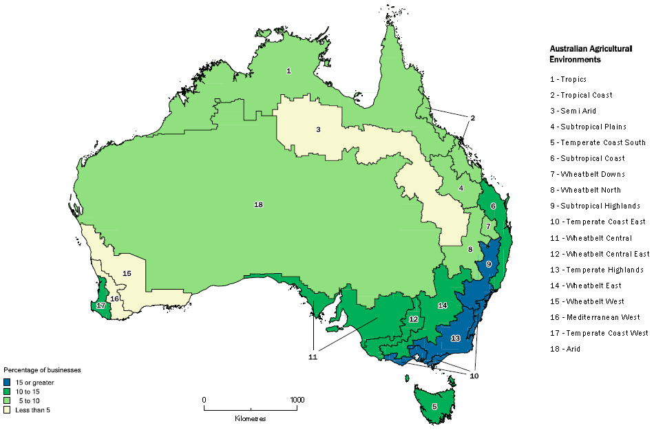
- Nationally, 4,800 agricultural businesses undertook some form of intercropping practices on 1.1 million hectares of land in 2015-16. New South Wales (incl. ACT) continues to be the main state reporting intercropping with 350,300 hectares (or 33%) of the nation's total area intercropped followed by Victoria with 302,900 hectares. Mixed inter-row/strip cropping continued to be the most common intercropping practice in Australia with 578,400 hectares (or 55%) of the total area intercropped.
Percentage of cropping businesses undertaking intercropping, 2015-16
by Australian Agricultural Environment Regions
CHANGE IN COLLECTION SCOPE
- The scope for the 2015-16 Agricultural Census and Land Management Practices Survey was all agricultural businesses with an Estimated Value of Agricultural Operations (EVAO) of $40,000 or greater. This is a change from previous ABS rural environment and agricultural collections, where a scope of EVAO of $5,000 or greater was used. This change was foreshadowed in February 2016 in Agricultural Census: Nature and Content, 2015-16 (cat. no 7100.1).
- The 2014-15 estimates presented in this publication have been revised to use the new scope of $40,000 or greater.
- For more information about EVAO and the change in scope, refer to the Explanatory Notes within this release.
|
|
 Quality Declaration
  Print Page
 Print All