GEOGRAPHY INCLUDED
Regional Statistics Northern Territory, 2008 presents data by several different geographical classifications. These regions include the 2006 Australian Standard Geographic Classification (ASGC), Northern Territory Government (NTG) Statistical Regions, Tourism regions, as well as some discrete locations where appropriate.
The majority of the data presented in this publication is presented according the Main Structure of the ASGC 2006. In the Northern Territory (NT) this Main Structure is composed of the three Statistical Divisions (SDs) of Darwin SD, Remainder NT SD and Offshore SD. These in turn are made up of 12 Statistical Sub Divisions (SSDs), which are further broken down into 96 Statistical Local Areas (SLAs).
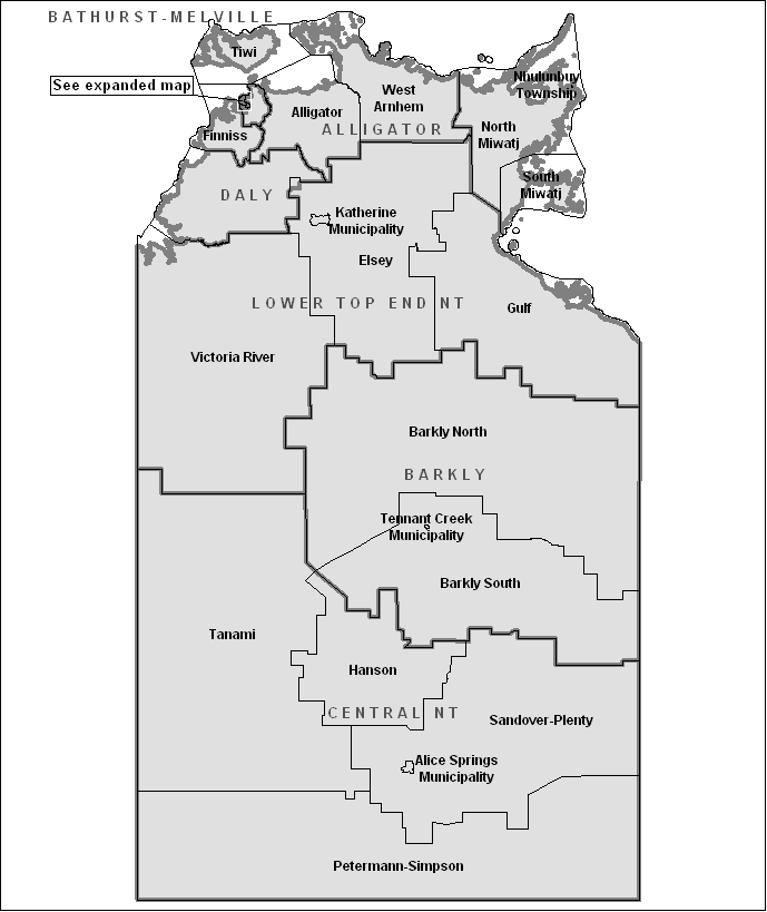
NTG Statistical Regions
In 2005, the Northern Territory Government (NTG) introduced the NTG Statistical Regions. These regions are the statistical boundaries by which all NT Government departments report, ensuring statistical data compiled by the NT Government is geographically consistent and therefore comparable. NTG Statistical Regions consist of five major regions (Darwin, East Arnhem, Katherine, Barkly, Alice Springs) which are further broken down to 23 sub regions.
The NTG Statistical Regions were created with the assistance of the ABS and in most cases align with the 2006 ASGC areas. This means that it is possible to convert data presented by ASGC areas to NTG Statistical Regions, and vice versa. The following maps and table outline the major regions and sub-regions and their alignment with the 2006 ASGC SSDs and SLAs.
Postcode level data
Some of the administrative data presented is compiled from aggregated postcode level data. In order to achieve consistency with data presented by ASGC boundaries, population-weighted concordances were applied to postcode level data. However, the translation of postcodes to SLAs is an inexact process since population distributions within Collection Districts (CDs) are not always evenly distributed. Some adjustment is made when creating concordances to account for population distributions within CDs based upon demographic intelligence. Updates to these concordances (current and historical) are made periodically, depending on new information and resources available. Similarly, the variable within a population may not necessarily be evenly distributed. Statistics resulting from such concordances will be less accurate if the variable being concorded is not distributed across the postcode in the same way that the population is distributed.
Post Office Boxes are generally excluded from postcode concordances as they are not representative of residential localities. For the current Australia Post postcode-locality listing see the Australia Post web site.
ASGC Statistical Subdivisions and associated NTG Sub-regions
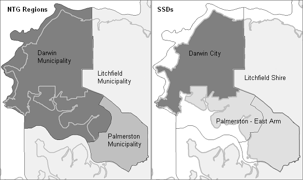
Darwin and Palmerston regional boundaries
 Print Page
 Print All