|
|
 LOCAL GOVERNMENT DATA MADE EASY LOCAL GOVERNMENT DATA MADE EASY
Did you know that the ABS has statistical profiles for Local Government Areas in the National Regional Profile? This is a great place to start if you are looking for data about the economy and people in your Local Government Area (LGA), plus much more.
Your LGA is easy to find using a map, list or search bar. The profiles contain a range of data from the ABS and other sources in a five year time series up to 2009. You can also find profiles for your state or territory and Australia.
WHAT CAN FIND OUT ABOUT YOUR LOCAL GOVERNMENT AREA?
Some examples include: How many people live in your Local Government Area? What is the birth rate? What is the average taxable income? How many registered motor vehicles are there?
In this article the Mornington Peninsula Local Government Area in Victoria, is used as an example of how you can use data in the profiles to explore a Local Government Area.
MORNINGTON PENINSULA
At 30 June 2009 the Local Government Area of Mornington Peninsula was the eleventh most populous LGA in Victoria. As can be seen from the image below, the region is bordered mostly by coastline with Western Port on the east, Port Phillip Bay on the west and Bass Strait to the south. This region is located to the south-east of Melbourne.
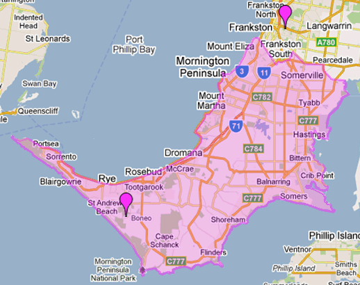
Image taken from the National Regional Profile
 |
Population
As at 30 June 2009 the LGA of Mornington Peninsula had an estimated resident population of 148,394, comprising 75,273 females and 73,121 males. From 30 June 2005 to 30 June 2009 the population grew by 6.7%, compared with growth of 7.8% for Victoria over the same period.
As shown in Graph 1. the largest age range in Mornington Peninsula in 2009 was the 45 to 59 age group, representing 19.8% of the region's population. At the time of the 2006 Census 18.6% of Mornington Peninsula's usual residents were born overseas, compared with the state average of 25.4%. In 2008 Mornington Peninsula had a higher fertility rate than Victoria (2.1 compared with 1.8).
Economy
For the June quarter 2009, Mornington Peninsula had an estimated Unemployment rate of 3.6%, well below the Australian and Victorian unemployment rates, which were 5.0% and 5.1% respectively for the same period.
The region's average Wage and salary income in 2007-08 was $39,656, lower than the Victorian average ($42,782). At this time Mornington Peninsula's most common occupation was Intermediate Clerical, Sales and Service Workers representing 17.5% of Wage and salary earners. Professionals were the second most common occupation representing 17.3% of Wage and salary earners.
As at 30 June 2009, 20,285 people in the Mornington Peninsula received an Age Pension from Centrelink, and 82 received and Age Pension from DVA. In Mornington Peninsula, the estimated resident population aged 65 and over was 20.0% of the total population, compared with 13.6% for Victoria.
Industry
Being close to Melbourne, the region may be a popular destination for a 'weekend away' or a longer stay. In 2008-09 Mornington Peninsula had 35 Hotel/Motels/Serviced Apartments with 5 or more rooms. It also had 32 Caravan Parks which was approximately 8% of Victoria's total.
The largest use of agricultural land in 2005-06 was for growing Vegetables for human consumption, with 1,961 hectares. All fruit (excluding grapes) was the next highest use covering 445 hectares, followed closely by Orchard trees (including nuts) with 440 hectares. Meat cattle was the most prevalent livestock with 16,474 head followed by Sheep and lamb (4,409 head). Mornington Peninsula had a small number of Milk cattle (excluding house cows) and Pigs, with 36 and 16 respectively. The Gross value of livestock slaughterings was $85.3 million, with the Gross value of crops at $80.6 million.
In 2008-09 the Average value of private sector house approvals was $320,500, a 31.3% increase from 2004-05. In 2008-09, 955 Private sector houses were approved, a decrease from 1,305 in 2004-05.
As at 31 March 2009 Mornington Peninsula had a high number of Total registered motor vehicles with 778 per thousand population, compared with Victoria (739) and Australia (714). This was an increase from 757 per thousand population in 2005. Mornington Peninsula also had a high number of Registered passenger vehicles per thousand population (620) in 2009, compared with Victoria (586) and Australia (548).
In Mornington Peninsula 46.5% of Total registered motor vehicles were aged 10 years or over, which was similar to the proportion of older vehicles in Victoria and Australia, with 46.3% and 45.0% respectively.
Environment
In 2005-06 approximately 2,000 hectares of land in this region were irrigated, which was 7.1% of all agricultural land in the Mornington Peninsula. This was larger than the percentage for Victoria (5.3%). The total water use on farms in Mornington Peninsula was 8,985 ML, which was 0.3% of all water used on Victorian farms.
For more information on the Mornington Peninsula LGA or any other of the 2,000 regional profiles, see the National Regional Profile. You can view or download data for than one region at a time, or download data for all regions. Go to 'How to Find a Region' and 'Compare Regions' for help in finding your region of interest. |
|
|
 Print Page