|
|
POPULATION
POPULATION GROWTH
Australia's estimated resident population of 20.3 million at June 2005 has grown by nearly 2.3 million people or 12.5% during the past decade. The growth of Australia's population has two components: natural increase (the number of births minus the number of deaths) and net overseas migration (net permanent and long-term migration). For state and territory estimates, a third component – net interstate migration – is also included.
Since Federation in 1901, Australia's population has increased by 16.6 million people. The graph shows the growth in Australia's population since European settlement in 1788.
Fifty years ago, Australia was in the midst of a baby boom. In 1955, the crude rate of natural increase was 13.7 people per 1,000 population. The rate increased to a peak of 14.3 in 1961, after which declining fertility led to a fall in the rate of natural increase. The rate of natural increase rose again in the late-1960s, reaching a peak of 12.7 people per 1,000 population in 1971. A decade later the rate had fallen to 8.5. In 1996, the rate of natural increase fell below 7.0 for the first time in Australia's history. This downward trend continued, reaching the lowest ever rate of natural increase (6.0 people per 1,000 population) in 2002 and 2003. In recent years there has been a slight increase in natural increase to 6.6 people per 1,000 population in 2005. ABS population projections suggest that continued sub-replacement fertility, combined with an increase in deaths due to an ageing population, will result in natural increase falling below zero around the middle of this century.
Even so, future projections indicate that Australia’s population could range between 25 and 33 million people by the year 2051, depending on various assumptions about future levels of fertility, mortality and overseas migration.
POPULATION GROWTH
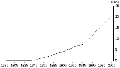 Source: Australian Historical Population Statistics, 2006 (3105.0.65.001);
Australian Demographic Statistics, December Quarter 2005 (3101.0).
Source: Australian Historical Population Statistics, 2006 (3105.0.65.001);
Australian Demographic Statistics, December Quarter 2005 (3101.0). POPULATION DISTRIBUTION
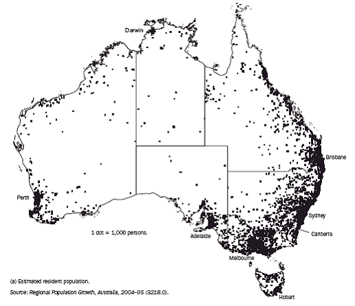
Most of Australia’s population is concentrated in two widely separated coastal regions: the south-east/east, and the south-west. Of the two regions, the south-east/east is by far the largest in area and population. The population within these regions is concentrated in urban centres, particularly in the state and territory capital cities.
Australia's population density at June 2005 was 2.6 people per square kilometre (km˛), compared with 2.5 people per km˛ in 2000. Of the states and territories, the Australian Capital Territory had the highest population density at June 2005 with 138 people per km˛ (reflecting the fact that the city of Canberra constitutes a large proportion of the Australian Capital Territory's area), followed by Victoria with 22 people per km˛. The Northern Territory had a population density of only 0.1 people per km˛, the lowest of all the states and territories (reflecting more recent settlement, distance from areas settled earlier, large arid areas and perhaps, climate).
Within the states and territories, population density was highest in the city centres, particularly in Sydney. The Sydney region had the three most densely populated Statistical Local Areas (SLAs) in Australia. These were Sydney (C) Central (8,400 people per km˛), Waverley (A)(6,600 people per km˛) and North Sydney (A) (5,800 people per sq km). Fourth on the list and Victoria's most densely populated SLA was Port Phillip (C) – St. Kilda (5,600 people per km˛). The SLA of New Farm in inner Brisbane (5,400 people per km˛) was Australia's fifth-most densely populated SLA.
POPULATION DISTRIBUTION, June 2005
POPULATION AGE AND SEX STRUCTURE
The age structure of Australia’s population has changed significantly over the past century. In the last 50 years, the absolute number of people has increased in all age groups. However, the proportion of the population in older age groups has increased while the proportion in younger age groups has declined.
The graph above shows the proportions of the population by age group and sex in 1955 and 2005, illustrating the ageing of Australia's population.
In June 2005, the largest number of people of any age was 34 years, with 322,300 people. This corresponds to the large cohort born in 1971.
Australia's population is ageing because of sustained low fertility, resulting in proportionally fewer children in the population, and increased life expectancy, resulting in proportionally more older people in the population.
The ageing of Australia’s population changes consumption patterns, influencing the quantity and quality of resources used and waste generated by the community. For example, expenditure on personal travel and health is increasing in Australia, as is the purchase of second homes.
For further information on Australia's population age and sex structure, visit the Animated Population Pyramid at the Australian Bureau of Statistics web site: https://www.abs.gov.au/websitedbs/d3310114.nsf/home/population%20pyramid%20preview
SELECTED POPULATION INDICATORS, 2005 |
|
 | Major
cities | Inner
regional | Outer
regional | Remote | Very
remote | Aust. |
|
| Population ('000) | 13 454 | 4 302 | 2 069 | 323 | 180 | 20 329 |
| Share of total population (%) | 66.2 | 21.2 | 10.2 | 1.6 | 0.9 | 100.0 |
| Population growth, 2000–2004 (%) | 6.4 | 9.1 | 3.1 | –3.4 | 3.7 | 6.4 |
| Area ('000 km˛) | 14 | 220 | 803 | 1 021 | 5 646 | 7 704 |
| Population density (persons/km˛) | 937.5 | 19.6 | 2.6 | 0.3 | 0.0 | 2.6 |
| People living in the same state /territory 5 years ago (2001) (%) | 96 | 96 | 96 | 94 | 91 | 95 |
|
Note: Population estimates for 2005 are preliminary.
Source: ABS Regional Population Growth, Australia, 2004–05 (cat. no. 3218.0); ABS 2001 Census of Population and Housing, internal migration (place of usual residence). Bureau of Transport and Regional Economics, About Australia’s Regions, 2006. |
POPULATION GROWTH BY STATE/TERRITORY AND REMOTENESS AREA, 2000–05
The tables above show population growth and decline from both natural increase and from people moving into cities and coastal areas, and out of rural and remote areas.
The “sea change” phenomenon is well recognised, whereby people are moving to coastal areas. This is linked to a number of factors, including tourism development, people relocating upon retirement and young people seeking a change of lifestyle.
Where people live has important environmental implications. For example, increasing numbers of people in certain areas, such as cities, can affect air pollution.
The concentration of people in coastal areas of south-eastern Australia has resulted in relatively high rates of land clearing of native bushland and agricultural land for residential development. This has caused loss of habitat for native plants and animals, which reduces their numbers and geographical spread. Urban developments also need water and sewerage services and landfill sites, all of which can affect the environment.
The coastal strip is also of environmental significance because it is the source of most of the pollutants and nutrients that run-off into estuaries and coastal seas.
POPULATION GROWTH BY STATE/TERRITORY AND REMOTENESS AREA, 2000–05 |
|
| State/Territory | Major cities | Inner regional | Outer regional | Remote | Very remote | Australian total |
| % | % | % | % | % | % |
|
| NSW | 5 | 5 | 0 | -3 | -1 | 4 |
| Vic | 7 | 8 | 1 | -4 | n.r. (a) | 7 |
| Qld | 12 | 15 | 8 | 2 | 2 | 12 |
| SA | 2 | 9 | -3 | 2 | -9 | 2 |
| WA | 7 | 19 | 1 | -4 | -2 | 7 |
| Tas | n.r. (a) | 4 | 1 | 1 | -7 | 3 |
| NT | n.r. (a) | n.r. (a) | 8 | -18 | 19 | 4 |
| ACT | 3 | -2 | n.r. (a) | n.r. (a) | n.r. (a) | 3 |
| | | | | | |
| Total | 6 | 9 | 3 | -3 | 4 | 6 |
|
Note: Estimates for 2005 are preliminary. Figures are total percentage growth over the period 2000–2005.
(a) For the purpose of the ABS Remoteness Structure, there are no regions in this category for this state or territory.
Source: ABS Regional Population Growth, Australia, 2004–05 (cat. no. 3218.0); ABS estimated resident population data. Bureau of Transport and Regional Economics, About Australia’s Regions, 2006. |
LOCAL GOVERNMENT AREAS WITH FASTEST POPULATION INCREASES/DECREASES, 2000–2005
Population growth has occurred unevenly across the states and territories. The proportion of Australia's population resident in each state and territory has changed over time. Between 1955 and 2005, the proportion of the Australian population living in New South Wales fell (from 37.9% to 33.3%), as did Victoria (from 27.4% to 24.7%), South Australia (8.9% to 7.6%) and Tasmania (3.4% to 2.4%). The proportion of Australia's population living in all other states and territories increased over the same period. Queensland increased its share of population from 14.7% in 1955 to 19.6% in 2005.
LOCAL GOVERNMENT AREAS WITH FASTEST POPULATION INCREASES, 2000–2005
|
| LGA | State | Remoteness area | Average annual growth rate (%) |
|
| Perth | WA | Major Cities | 10.5 |
| Melton | VIC | Major Cities | 9.3 |
| Capel | WA | Inner Regional | 7.4 |
| Wyndham | VIC | Major Cities | 6.3 |
| Melbourne | VIC | Major Cities | 6.1 |
| Wanneroo | WA | Major Cities | 5.9 |
| Mandurah | WA | Inner Regional | 5.6 |
| Casey | VIC | Major Cities | 4.6 |
| Cardinia | VIC | Major Cities | 4.5 |
| Chittering | WA | Inner Regional | 4.5 |
|
Table excludes LGAs with population of less than 1,000 in 2000. Population estimates for 2005 are preliminary.
Source: ABS Regional Population Growth, Australia, 2004–05 (cat. no. 3218.0). LGAs were coded to remoteness classes derived by the Bureau of Transport and Regional Economics. The majority of the LGA's population fits within the stated Remoteness Area. |
LOCAL GOVERNMENT AREAS WITH FASTEST POPULATION DECREASES, 2000–2005 |
|
| LGA | State | Remoteness area | Average annual growth rate (%) |
|
| Dundas | WA | Remote | -5.0 |
| Yilgarn | WA | Remote | -4.4 |
| Dalwallinu | WA | Remote | -4.3 |
| Leonora | WA | Very Remote | -3.5 |
| Coober Pedy | SA | Very Remote | -3.4 |
| Coolgardie | WA | Outer Regional | -3.3 |
| Gnowangerup | WA | Remote | -3.2 |
| Morowa | WA | Remote | -3.1 |
| Quairading | WA | Outer Regional | -2.9 |
| Cunderdin | WA | Outer Regional | -2.8 |
|
Table excludes LGAs with population of less than 1,000 in 2000. Population estimates for 2005 are preliminary.
Source: ABS Regional Population Growth, Australia, 2004–05 (cat. no. 3218.0). LGAs were coded to remoteness classes derived by the Bureau of Transport and Regional Economics. The majority of the LGA's population fits within the stated Remoteness Area. |
|
|
|
 Print Page
 Print All