FEATURE ARTICLE 1: REGIONAL HOUSEHOLD AND FAMILY CHARACTERISTICS IN WESTERN AUSTRALIA
INTRODUCTION
Western Australia's population has increased substantially in recent years, creating challenges for state and local governments in the areas of planning, service delivery and infrastructure needs. The recent changes to patterns of migration and internal mobility, as well as family and household composition, highlight the effects of the recent significant economic growth on Western Australia's home life and local communities.
This article analyses how the latest Western Australian population data from the 2006 Census of Population and Housing has changed from the previous Census collections in 1996 and 2001. This analysis complements the Regional Housing in Western Australia article (released in this publication for the December 2007 quarter) to provide an holistic analysis of economic and social data for selected regions in Western Australia.
DIFFERING POPULATION MEASURES
Census of Population and Housing
The Census of Population and Housing is conducted every 5 years and provides a rich data source for measuring changes in population numbers and characteristics for various geographic areas in Australia. The Census provides two important population counts for areas in Australia:
- Place of enumeration - is a count of the number of people based on where they slept on Census night.
- Place of usual residence - the Census asks people to provide their usual address (i.e. for more than 6 months of the year), if they were not staying at home on Census night.
Estimated Resident Population
The Estimated Resident Population (ERP) series is the official measure of population change for areas in Australia. The ERP provides a more accurate measure than the Census of population growth and decline as it adjusts for known limitations in Census data. While the Census aims to count everyone in Australia on Census night, some people are missed or counted more than once. The ABS conducts a Post Enumeration Survey (PES) after each Census to estimate the number of people who were missed or counted more than once in the Census. In Census years, the PES results allow Census data to be adjusted to more accurately reflect actual resident populations for areas in Australia. Other adjustments applied to Census counts to obtain ERP in Census years include removing the count of overseas visitors, adding Australian residents temporarily overseas and timing adjustments which take into account that the Census is conducted in August while ERP is calculated for 30 June. For a more detailed explanation about ERP see
Demography, Australia (cat. no. 3101.0). The table below illustrates how the 2006 Census data was adjusted to obtain 30 June 2006 ERP.
ADJUSTMENT COMPONENTS OF ESTIMATED RESIDENT POPULATION, preliminary - 30 June 2006 |
|  |
| WA | |
| Components as at 8 August 2006: | ('000) | |
| |
| Census count, place of enumeration | 1 986.2 | |
| plus - residents absent interstate | 19.2 | |
| less - interstate visitors | 25.1 | |
| less - overseas visitors | 21.3 | |
| equals - Census count, place of usual residence | 1 959.1 | |
| plus - allowance for under-enumeration(a) | 64.1 | |
| plus - demographic adjustment(a)(b) | -1.4 | |
| plus - residents temporarily overseas(a) | 41.7 | |
| equals - ERP as at 8 August 2006(a) | 2 063.6 | |
| less - births(a)(c) | 3.0 | |
| plus - deaths(a)(c) | 1.3 | |
| less - net interstate migration(a)(c) | 0.4 | |
| less - net overseas migration(a)(c) | 2.5 | |
| equals - preliminary ERP 30 June 2006 | 2 059.0 | |
| |
| (a) These estimates are preliminary and may change in compilation of final rebased estimates. |
| (b) Demographic adjustments are designed to resolve any statistical anomalies in the age sex composition of the derived population estimates. |
| (c) Component data calculated for the period 1 July to 8 August 2006. |
| Australian Demographic Statistics, March 2007, cat. no. 3101.0) |
For the purposes of the regional analysis in this article, the Census usual residence counts will be used, because additional information about household or family composition is sourced from Census data, rather than ERP. However, as ERP is the official population measure, the table below has been included for the selected regions to show the official population changes for the last ten years.
ESTIMATED RESIDENT POPULATION(a), selected local government areas, 1996 to 2006 |
| |
| ERP at 30 June | Change | Change | |
| 1996 | 2001 | 2006 | 1996-2001 | | 2001-2006 | | |
| no. | no. | no. | no. | % | no. | % | |
| |
| Albany (C) | 28 148 | 31 236 | 33 144 | 3 088 | 11.0 | 1 908 | 6.1 | |
| Beverley (S) | 1 453 | 1 573 | 1 638 | 120 | 8.3 | 65 | 4.1 | |
| Chittering (S) | 2 409 | 2 936 | 3 683 | 527 | 21.9 | 747 | 25.4 | |
| Northam (T) | 6 471 | 6 573 | 6 412 | 102 | 1.6 | -161 | -2.4 | |
| Northam (S) | 3 239 | 3 670 | 3 959 | 431 | 13.3 | 289 | 7.9 | |
| Toodyay (S) | 3 363 | 4 068 | 4 309 | 705 | 21.0 | 241 | 5.9 | |
| York (S) | 2 904 | 3 233 | 3 260 | 329 | 11.3 | 27 | 0.8 | |
| Avon Arc | 19 839 | 22 053 | 23 261 | 2 214 | 11.2 | 1 208 | 5.5 | |
| Broome (S) | 9 766 | 13 196 | 14 436 | 3 430 | 35.1 | 1 240 | 9.4 | |
| Bunbury (C) | 27 641 | 30 493 | 31 421 | 2 852 | 10.3 | 928 | 3.0 | |
| Busselton (S) | 18 158 | 23 099 | 26 638 | 4 941 | 27.2 | 3 539 | 15.3 | |
| Dalwallinu (S) | 1 767 | 1 882 | 1 443 | 115 | 6.5 | -439 | -23.3 | |
| Geraldton (C) | 20 200 | 20 130 | 20 233 | -70 | -0.3 | 103 | 0.5 | |
| Kalgoorlie/Boulder (C) | 29 587 | 29 651 | 30 399 | 64 | 0.2 | 748 | 2.5 | |
| Leonora (S) | 2 774 | 1 998 | 1 529 | -776 | -28.0 | -469 | -23.5 | |
| Mandurah (C) | 40 460 | 48 877 | 58 457 | 8 417 | 20.8 | 9 580 | 19.6 | |
| Roebourne (S) | 13 829 | 15 058 | 17 671 | 1 229 | 8.9 | 2 613 | 17.4 | |
| Western Australia | 1 765 256 | 1 901 159 | 2 059 045 | 135 903 | 7.7 | 157 886 | 8.3 | |
| |
| (a) The regions selected are for local government areas only. This article includes Census geography which combines local government areas and statistical local areas. As ERP is not generated for the Census regions, the population data is not directly comparable for all geographic regions. |
| Regional Population Growth, 1996 to 2006, cat. no. 3218.0. |
REGIONAL ANALYSIS
To complement the Regional Housing in Western Australia article published last quarter, the same geographic regions for analysis have been included. These areas were chosen to provide a diverse picture of Western Australia that is often masked by whole of state analysis. Large population numbers in urban areas, such as Perth, often disguise regional trends and patterns.
Below is a description of the geographic areas included in this article which relate to the 2006 Australian Standard Geographic Classification (cat. no. 1216.0).
- Albany, identified as the City of Albany.
- Avon Arc, is a region east of Perth which comprises the Shires of Beverley, Chittering, Toodyay, York, Northam and the Town of Northam. This region is recognised by state government agencies for planning and development resources as well as associations, such as the Real Estate Institute of WA (REIWA). The Town and Shire of Northam were amalgamated in July 2007.
- Broome, identified as the Shire of Broome.
- Bunbury is the Bunbury Statistical Subdivision which covers the LGAs of the City of Bunbury plus the Statistical Local Areas (SLA) of Capel Part A, Dardanup Part A and Harvey Part A. The Part A SLAs are an urban fringe which surrounds the City of Bunbury.
- Busselton, identified as the Shire of Busselton.
- Dalwallinu, identified as the Shire of Dalwallinu.
- Geraldton, which is covered by the Geraldton Statistical Subdivision. This includes the City of Geraldton and the adjoining urban portion of the Shire of Greenough. These two LGAs were amalgamated in mid-2007.
- Kalgoorlie is the SLA of Kalgoorlie Part A which covers the urban portion of the City of Kalgoorlie/Boulder.
- Leonora, identified as the Shire of Leonora.
- Mandurah is the Mandurah Statistical Subdivision which comprises the LGAs of the City of Mandurah and the Shire of Murray.
- Roebourne, identified as the Shire of Roebourne.
WESTERN AUSTRALIA - usual residence
Western Australia's usual resident population was 1,959,090 in 2006, an increase of 153,570 people (8.5%) from 2001. The 2001 to 2006 population increase in Western Australia was the second highest of all states and territories, behind Queensland (11%), and higher than the national average (5.5%).
Change of address (usual residence five years ago)
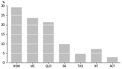
Migration was the most significant contributor to Western Australia's population increase between 2001 and 2006. It is therefore not surprising that in the 2006 Census, almost one in ten (9% or 165,460) Western Australian residents (aged 5 years or older) indicated that their usual residence had been outside the state in 2001. The majority of these movers had been living overseas in 2001 (61%), while the remainder had lived in another state or territory (39%). Of the 64,370 people who had lived elsewhere in Australia in 2001, almost one-third had lived in New South Wales (29%), a further one-quarter in Victoria (24%) and 21% in Queensland.
WA CHANGE OF ADDRESS, Inter-state movers (state or territory usual residence in 2001)
Age and sex profile
The median age for Western Australians in 2006 was 36 years, three years older than in 1996 (33 years). The changing proportions of children (less than 15 years) and older people (aged 65 years or more) highlights our ageing population. Between 1996 and 2006, the proportion of children in the state decreased from 23% to 20%, while the proportion of older people increased from 10% to 12%. Even though the number in both age groups grew over the ten year period, the increase in the number of older people was five times higher than that of children (57,900 and 11,400 persons respectively).
The increase in the number of females (76,030) residing in Western Australia was slightly less than that of males (77,540) between 2001 and 2006. This was reflected in the slight shift in the sex ratio which increased from 99.1 to 99.3 males per 100 females.
Household and family composition
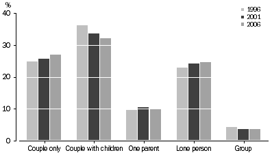
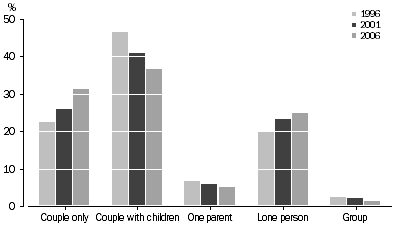
In 2006, there were 703,170 households in Western Australia, 6.6% more than were counted in the 2001 Census. While family households (72%) remained the dominant household type in Western Australia, non-family households, such as lone person and group households, increased more rapidly between 2001 and 2006. Family households increased by 6% compared with 8% in the number of non-family households.
Families with children remained the largest household type in Western Australia in 2006, with one-third of all households being couples with children (32%) and a further 10% being one parent families. However, couple only families with no children experienced the largest growth of all household types, increasing by 12% (21,090 households) between 2001 and 2006. This increase was almost five times greater than the increase in couple with children households over the same period (2% or 4,540 households). The number of one parent households grew by 2% over this period, though the proportion decreased slightly (11% down to 10%). The large growth in couple only households can be partly attributed to an ageing population, with increasing numbers of households becoming 'empty nesters' as adult children leave home. The trend among younger adults starting families later could also be a contributing factor.
In 2006, more than one-quarter of households in Western Australia were non-family households (28% or 198,870 households). The majority were lone person households (87%), which had the second highest growth of all household types between 2001 and 2006 (8.3%). Group households, consisting of unrelated individuals living together, increased by 2% over the same period. The graph below shows how household types have changed as a proportion of total households counted in the 1996, 2001 and 2006 Census. Therefore the proportional changes represented are different from the changes discussed above, which identify changes between Censuses for individual household types.
WESTERN AUSTRALIA, Household and family composition
ALBANY - usual residence
The City of Albany had a usual resident population of 31,580 in 2006, which is an increase of 9% since the 2001 Census and an increase of 15% since the 1996 Census. The growth in the population was slightly higher than the population growth for Western Australia (8.5%).
Change of address (usual address five years ago)
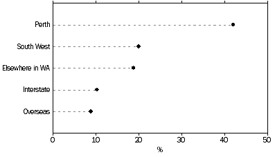
Almost one-third of Albany usual residents stated they lived at a different address outside the LGA five years prior to the 2006 Census (32% or 9,420). One in five residents had previously lived in the Perth metropolitan area (22%) while 7% had lived in the surrounding LGAs of Denmark and Plantagenet and 5% in the South-West. A further 8% lived in another state or territory.
Age and sex profile
Albany had a high median age of 39 years, 3 years older than the WA median age (36 years). Albany's median age followed similar trends of other regional communities in Western Australia increasing by 2 years from 2001. Albany had a large proportion of its population over 65 years old (16% compared with 12% for Western Australia). The only other selected region which had a higher proportion of usual residents aged 65 years or older was Mandurah (20%).
Albany had a sex ratio of 97.8 males per 100 females, which was slightly lower than WA's 99.3 males per 100 females.
Household and family composition
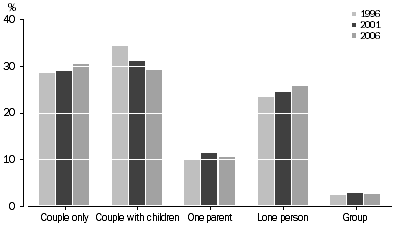
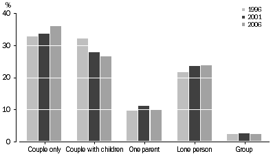
The number of households in Albany grew by 7% between 2001 and 2006. Household types which increased the most were lone person households (13%) and couple only families (12%). The graph below shows how household types have changed as a proportion of total households counted in the 1996, 2001 and 2006 Census. Therefore the proportional changes represented are different from the changes discussed above, which identify changes between Censuses for individual household types.
ALBANY, Household and family composition
AVON ARC - usual residence
In 2006 there were 22,100 usual residents living in the Avon Arc region, an 8% increase from 2001 and a 14.5% increase from 1996. There were considerable differences between the region's LGAs. In 2006, the largest number of residents in the Avon Arc lived in the Town of Northam (6,010) and the Shire of Toodyay (4,110) while the Shire of Beverley (1,560) had the smallest number. The Shire of Chittering experienced the largest increase in the region, growing by 28% from 2,750 to 3,520 between 2001 and 2006, proportionately more than three times the WA increase (8.5%). This LGA is located next to the Shire of Wanneroo which had the largest growth between 2001 and 2006 or all LGAs in Western Australia (37%). Therefore the increases shown in the Shire of Chittering could reflect the expansion of the metropolitan area due to housing affordability and the availability of nearby service infrastructure in Wanneroo.
Change of address (usual address 5 years ago)
Although one in three residents in the Avon Arc had lived at a different address within or outside the region five years earlier (33%), the majority had resided in Western Australia (88%). Of these, 60% had moved from Perth, evidence the region is seen as a popular 'tree change' destination, with improved infrastructure access to the Perth metropolitan area.
Age and sex profile
The Avon Arc region had an older age structure compared to WA (median 41 years compared to 36 years). In 2006, the Shire of Beverley had the oldest median age in the region and in the state (49 years). All the other LGAs had median ages above the state average, except for the Town of Northam (36 years).
Between 2001 and 2006, the proportion of older residents (aged 65 years or more) living in the Avon Arc region increased from 12% to 14%. Overall the number of older people increased by almost one-quarter (23%). There was no change in the proportion of children aged under 15 years (22% for 2001 and 2006).
In 2006 the sex ratio of the Avon Arc region was 101.6 males for every 100 females, slightly above the state sex ratio of 99.3 males for every 100 females. The Shire of Beverley had the highest sex ratio in the Avon Arc region, with 107.4 males for every 100 females while the Town of Northam had the lowest, 95.4 males per 100 females.
Household and family composition
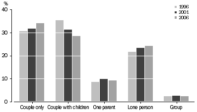
In 2006, there were 8,160 households in the Avon Arc region, an increase of 8% from 2001. The Shire of Chittering experienced the highest household growth of all LGAs (30%), followed by the Shire of Toodyay (11%). The Town of Northam was the only LGA in the region to experience a fall in the number of households between 2001 and 2006 (decrease of 2%).
Households were more likely to consist of couple only families (34%). There were also less couple families with children in the region compared to the state (28% compared to 33%). Couple only families experienced the highest increase of all selected households in the Avon Arc region between 2001 and 2006 (16%). This trend is consistent with the older age profile of the region, with many couple families likely to be 'empty nesters' whose children have left home. Lone person households made up almost one-quarter (24%) of the selected household group in Avon Arc region, a similar proportion for Western Australia (25%).
The graph below shows how household types have changed as a proportion of total households counted in the 1996, 2001 and 2006 Census. Therefore the proportional changes represented are different from the changes discussed above, which identify changes between Censuses for individual household types.
AVON ARC, Household and family composition
BROOME - usual residence
In the 2006 Census there were 13,060 usual residents counted in the Shire of Broome, 6% (760 people) more than 2001 and an increase of 3,550 residents from 1996.
Change of address (usual address 5 years ago)
Almost one third of people living in Broome (aged 5 years and over) in 2006 had lived outside the shire in 2001 (32% or 3790 people). Of these, almost two-thirds had lived elsewhere in Western Australia (64%). It should be noted that Broome had a high proportion of persons who did not state their usual address five years ago (19% compared to 8% for Western Australia). Therefore, it is probable that a higher proportion of residents had lived outside of Broome in 2001.
Age and sex profile
The population of Broome had one of the youngest age profiles in Western Australia, with a median age of 32 years (36 years for Western Australia). Unlike most regions, the median age of Broome had not changed between 2001 and 2006. This is reflected in the higher proportion of children aged under 15 years (24% compared with 20% for Western Australia). Even though the proportion of children in Broome remained high between 2001 and 2006, the number of children declined from 3,210 to 3,140.
A lower proportion of people aged 65 years or older lived in Broome (5%) compared with Western Australia (12%). Another factor contributing to the younger age profile was the high proportion of Indigenous people living in the shire (3,560 or 27%). The median age of the Indigenous population was 22 years, 13 years lower than the non-Indigenous population (35 years).
The sex ratio of Broome residents was 106.8 males per 100 females.
Household and family composition
Between 2001 and 2006 there was only a 1% increase in the number of households in Broome (3,800 to 3,830 households), whereas visitor only and other non classifiable households increased by 27% (2,160 to 2,740). Broome also had the lowest proportion of family households of all the selected regions (69%). Lone person households in Broome had increased by 10% between 2001 and 2006.
Broome had the highest proportion of group households of all the selected regions (7% compared to 4% for Western Australia). It should be noted that the proportion of households in Broome that were not classified to a household type was considerably higher than the state average and therefore changes over time and comparisons with other regions should be used cautiously (42% compared to 7% for Western Australia).
BUNBURY - usual residence
There were 54,970 usual residents counted in the Bunbury region in 2006, which has more than doubled since 1996 (26,700 persons). Most of this population increase occurred in the statistical local areas (SLAs) of Capel Part A (172%), Dardanup Part A (77%) and Harvey Part A (46%) which surround the City of Bunbury. The SLA of Capel Part A had the greatest population increase in the Bunbury region, almost tripling in size from 2,150 to 5,870 between 1996 and 2006.
Change of address (usual address 5 years ago)
In 2006, approximately one in three persons living in the Bunbury region (under 5 years) had lived outside the area in 2001 (34% or 17,200). The majority had resided in Western Australia in 2001 (81%). Almost one-quarter had lived in other regions of the South-West (22%), in particular the SLAs of Capel Pt B, Harvey Pt B and Dardanup Pt B and the Shires of Collie and Busselton. Previous addresses also included the Perth metropolitan region (17%), another state or territory (9%) and overseas (10%).
Age and sex profile
The median age of usual residents in the Bunbury region, rose from 33 years in 2001 to 36 years in 2006. This increase is the result of a higher increase in the number of older people, aged 65 years or more (1,580 or 33%), compared with children aged 0-14 years (920 or 8%). The proportion of older people increased from 10% to 12% between 2001 and 2006, whereas the proportion of children decreased from 23% to 22%.
In 2006 there were 99.1 males for every 100 females residing in the Bunbury region, similar to the sex ratio for Western Australia and the region in 2001.
Household and family composition
In 2006, there were 19,490 households in the Bunbury region, an increase of 15% or 2,520 more than in 2001. This increase was proportionately more than twice that for Western Australia (7%). Family households accounted for three-quarters of all households (75%), a slightly higher proportion than the state average of 72%. Almost one-quarter of Bunbury households were lone person households (22%), the lowest proportion of all the selected regions.
BUSSELTON - usual residence
In 2006 there were 25,350 usual residents counted in the Shire of Busselton, 19% (4,020) more than in 2001 and 45% (7,910) more than in 1996.
Change of address (usual address 5 years ago)
In 2006, more than one in four Busselton residents (aged over 5 years) had resided outside the region in 2001 (28%). Of these, just under half (42%) had lived in the Perth metropolitan area, primarily in the LGAs of Joondalup, Stirling and Melville. A further 20% had previously resided in other areas of the South-West region, most commonly the LGAs of Augusta-Margaret River, Manjimup and Bunbury.
BUSSELTON CHANGE OF ADDRESS, usual residence in 2001
Age and sex profile
In 2006, the median age of usual residents in Busselton was 38 years which was two years older than the median age for Western Australia (36 years). Over this period, the number of residents aged more than 65 years increased by almost one-third (30%), a higher rate than the state increase (18%), but lower than the growth of this age group in Mandurah (43%) and Bunbury (33%).
The number of children in Busselton also increased by 10% between 2001 and 2006, which was substantially higher than the overall increase of children in Western Australia (2%).
Household and family composition
The number of households in the Shire of Busselton grew by 16% between 2001 and 2006 (7,770 to 9,050 households). The largest numeric increase in household type was for couple only families, which grew by 500 households (21%) between 2001 and 2006.
In 2006, family households accounted for approximately three-quarters of households in Busselton. Couple families with children and couple only families were the largest household types (32% and 31% respectively). Lone person households represented 22% of households in Busselton, a smaller proportion than the Western Australia average (25%).
DALWALLINU - usual residence
The Shire of Dalwallinu is located in the Wheatbelt region of Western Australia. Against the trend of population increase for Western Australia, many of the LGAs located in the Wheatbelt experienced population declines between 2001 and 2006. In 2006 the usual resident population of Dalwallinu was 1,370, a decline of 23% from 1,770 residents in 2001.
Change of address (usual address 5 years ago)
In 2006, residents of Dalwallinu were the least likely of all the selected regions to have been living outside the shire in 2001 (19%). Most Dalwallinu residents, who had lived elsewhere in 2001, had lived in the Perth metropolitan area (29%).
Age and sex profile
The age profile of Dalwallinu underwent a substantial change between 2001 and 2006. In 2001, Dalwallinu along with the Shire of Roebourne, had the youngest median age (31 years) of all the selected regions. By 2006, the median age of Dalwallinu residents increased by five years to 36 years (equal to the Western Australia median).
In 2001, the younger median age was largely due to the proportion of children (under 15 years) (28%). In 2006, while the proportion of children in Dalwallinu's population (24%) remained higher than the state average (20%), there were fewer children living in the area compared with 2001 (500 down to 320).
Dalwallinu had a male dominated population. In 2006, 111.3 males per 100 females lived in the Shire compared with 114.5 males per 100 females in 2001. As the population base is low, this is not a significant change with a similar percentage decline in both males and females over the 5 year period.
Household and family composition
Dalwallinu experienced a 13% decrease in the number of households counted between 2001 and 2006. By 2006, the number of households had fallen from 560 to 480. The proportion of couple with children families declined by 22% (50 households). While couple with children families continued to be the largest household type in Dalwallinu (37%), they represented fewer households compared to 2001 (41%).
The following graph shows how household types have changed as a proportion of total households counted in the 1996, 2001 and 2006 Census. Therefore the proportional changes represented are different from the changes discussed above, which identify changes between Censuses for individual household types.
DALWALLINU, Household and family composition
GERALDTON - usual residence
In 2006, there were 31,560 usual residents counted in the urban Geraldton region, an increase of 8% from 2001 (29,180). Most of the population growth in the Geraldton region occurred in the SLA of Greenough Part A (14%), the urban area surrounding the City of Geraldton. The number of usual residents in the City of Geraldton increased less over the same period (3%).
Change of address (usual address 5 years ago)
In 2006, more than one in four usual residents had been living elsewhere within or outside the region in 2001 (27%), with the majority having previously lived in Western Australia (83%). Of these, 39% had lived in Perth, 11% in the Pilbara region and 6% in the Shire of Northampton.
Age and sex profile
In 2006, the median age of usual residents in the Geraldton urban region was 35 years, two years older than in 2001 (33 years). With 24% of its population aged under 15 years, Geraldton had a slightly higher proportion of children compared to the state (20%). The proportion of older residents (more than 65 years old) increased by 22% from 2001. Approximately three-quarters of people aged 65 years old or more in the region, lived in the City of Geraldton.
The sex ratio of the population was 96.7 males per 100 females, similar to the ratio in 2001.
Household and family composition
The number of households in the Geraldton region grew by just under 3% between 2001 to 2006 (10,610 to 10,890 households). Over the same period, the number of couple only families increased by 13%, while one parent families fell by 8% (1,360 down to 1,240 households).
KALGOORLIE - usual residence
According to the 2006 Census, the urban area of Kalgoorlie/Boulder had a usual resident population of 28,240, an increase of 4% from the 2001 Census. This represented the smallest increase for all of the larger Western Australian urban localities.
Change of address (usual address five years ago)
In 2006, just under one-third of Kalgoorlie residents (aged over 5 years) were living elsewhere within or outside the region in 2001 (30%). Over half lived in Western Australia (56%) and a further one-quarter were previously living interstate (of these 50% were from Victoria and Queensland combined). Of all the selected regions, Kalgoorlie had the highest proportion of residents who had lived overseas five years before the 2006 Census (18%).
Age and sex profile
Kalgoorlie's population shared the youngest median age (31 years) with Leonora and Roebourne (compared to 36 years for Western Australia). The median age for Kalgoorlie has followed the ageing trend in other regions, increasing by 2 years from 2001. Approximately one-quarter of Kalgoorlie's population were aged under 15 years and there was a relatively small proportion of older people (aged more than 65 years) (5% compared with 12% for WA).
Kalgoorlie had a higher ratio of males in the population with 108.8 males per 100 females. This compares with the Western Australia sex ratio of 99.3 males per 100 females. In the five years from 2001, the female population has grown slightly faster than the male population (5% and 3% respectively).
Household and family composition
Kalgoorlie had the lowest proportion of couple only households in the state (24% compared with 27% for Western Australia). This reflects the higher proportion of children living in couple with children families (37% compared to 32% for Western Australia).
LEONORA - usual residence
In 2006, the Shire of Leonora recorded a usual resident population of 1,410, a fall of 27% from the 2001 Census. The population has almost halved since 1996 (a decrease of 47% or 1,260 residents).
Change of address (usual address 5 years ago)
Due to the volatility of mining projects in mining regions such as Leonora, population turnover is normally high and is dependant on project venture timing. Therefore it is not surprising that over half of the usual resident population of Leonora had lived outside the LGA five years earlier (53%). More than one-third (35%) had previously lived in Perth and a further 27% in another state or territory.
Age and sex profile
In 2006, the median age of Leonora's residents was 31 years. While other selected regions had a median age increase from the 2001 Census, Leonora's median population age actually declined by 2 years. Leonora had a high proportion of under 15 year olds (25%). The over 65 year old population was one of the smallest of all the selected regions (3%).
Leonora had a very high young male population. In 2006, for every 100 females there were 142.8 males, the highest ratio for all the selected regions due to the mining industry. From 2001 this ratio had declined due to the number of males, rather than females, leaving the LGA (167.1 males per 100 females in 2001). The male population dropped by 380 residents (31%), while the female population declined by 20% (140 residents).
Household and family composition
Leonora experienced a 10% decline in the number of households between 2001 and 2006 (430 down to 390 households). A high proportion of these households were persons living alone (26%), the highest proportion for all selected regions.
MANDURAH - usual residence
In 2006, there were 67,790 usual residents counted in the Mandurah region, 21.5% (12,000) more than in 2001 and 40% (19,410) up from 1996. Most (85%) of this population growth occurred in the City of Mandurah, which increased its usual resident count by 10,220 people. The Mandurah region grew at more than twice the rate for Western Australia (22% and 8.5% respectively) and had the highest growth of all the selected regions between 2001 and 2006.
Change of address (usual address 5 years ago)
Nearly one-third (30%) of Mandurah residents in 2006 had lived elsewhere within or outside the region in 2001. Of the people moving into Mandurah, 78% had previously lived elsewhere in Western Australia, with more than half from the Perth metropolitan area (56%). Coupled with age profile data, the mobility trend highlights Mandurah as a 'sea change' and retirees destination.
Age and sex profile
Mandurah's population had a median age that was 9 years higher than the WA average (43 years compared to 36 years). Between 2001 and 2006 the median age had risen by 3 years, resulting from the population aged under 15 years decreasing from 21% to 19% and the proportion of those aged 65 years or older increasing from 18% to 20%.
Household and family composition
Mandurah had the highest growth rate in the number of households in Western Australia between 2001 and 2006 (18% compared to 9% for Western Australia), resulting in an increase of 3,850 households for the region. The number of couple only households grew by 26% and the number of lone person households grew by 20%. The graph below shows how household types have changed as a proportion of total households counted in the 1996, 2001 and 2006 Census. Therefore the proportional changes represented are different from the changes discussed above, which identify changes between Censuses for individual household types.
MANDURAH, Household and family composition
ROEBOURNE - usual residence
In 2006, the Shire of Roebourne usual resident population was counted as 16,420, an increase of 15% (2,170) from 2001. This was the largest growth in population outside the selected South-West areas of Mandurah, Bunbury and Busselton. Most residents in the Shire of Roebourne lived in the urban centre of Karratha (11,720 residents), which increased by 9% between 2001 and 2006.
Change of address (usual address 5 years ago)
In 2006, 6,000 or 40% of usual residents living in Roebourne had not lived in the LGA five years earlier, the highest proportion of all the selected regions. Over one third (35%) of these residents had been living in Perth, while 22% had lived in another state or territory. A further 10% had been living overseas in 2001. Karratha had similar figures to the Shire of Roebourne with 44% of the population living elsewhere in 2001. However, it should be noted that 16% (2,410) of Roebourne residents did not answer the Census question on where they lived 5 years earlier, therefore, the number of people who had lived somewhere else in 2001 could be higher.
Age and sex profile
In 2006, the median age of Roebourne's usual resident population remained unchanged from 2001 (31 years). The median age in 2006 was five years younger than the Western Australia average of 36 years. Karratha residents had a slightly younger age profile with a median age of 30 years in 2006. Among all the selected regions, Roebourne had the highest proportion of children (aged 0-14 years) within its population, 24% or 3,920 people. Like most of the other selected regions, the proportion of children declined from 2001 (28%), though it remained substantially higher than the Western Australian average (20%). Roebourne's lower median age also resulted from far fewer older residents (aged 65 years or more) (2% compared to 12% for Western Australia).
The sex ratio among usual residents of Roebourne was relatively constant between 2001 and 2006 at 117 males per 100 females. Only Leonora had a higher male to female ratio of the selected regions in 2006.
Household and family composition
In 2006, there were 4,690 households in the Shire of Roebourne, an increase of 5% (200) since 2001. Over this period, the number of couple only families rose by 13% (150), whereas one parent households decreased by 11%. Like the Shire of Broome, there was a high proportion of visitor only or unclassifiable households (23% or 1,400 households), therefore changes over time and comparisons with other regions should be used cautiously.
REGIONAL COMPARISONS
Age and sex profile
As the following table illustrates, there are many differences between the selected regions in this article. The Mandurah region had the highest median age (43 years), which is reflected in the proportion of people aged 65 years or more (20.3%). Conversely Roebourne, Leonora, Kalgoorlie and Dalwallinu had the youngest age profile (median 31 years). The sex ratio for these regions have a higher proportion of males than females, which highlights the attraction of young males to employment in the mining and farming industries.
AGE AND SEX PROFILE, Regional comparison, 2006 Census |
| |
| Median Age | Aged under 15 years | Aged over 65 years | Sex Ratio Males per 100 females | |
| years | % | % | ratio | |
| |
| Albany (C) | 39 | 20.6 | 16.1 | 97.8 | |
| Avon Arc | 41 | 21.6 | 14.1 | 101.6 | |
| Broome (S) | 32 | 24.1 | 4.5 | 106.8 | |
| Bunbury (SSD) | 33 | 21.6 | 11.7 | 99.1 | |
| Busselton (S) | 38 | 21.9 | 15.3 | 97.3 | |
| Dalwallinu (S) | 31 | 23.8 | 12.6 | 111.3 | |
| Geraldton (SSD) | 33 | 23.7 | 11.8 | 96.7 | |
| Kalgoorlie (SSD) | 31 | 24.9 | 5.2 | 108.8 | |
| Leonora (S) | 31 | 24.1 | 3.4 | 142.8 | |
| Mandurah (SSD) | 43 | 18.9 | 20.3 | 96.6 | |
| Roebourne (S) | 31 | 25.9 | 1.9 | 117.0 | |
| Western Australia | 36 | 20.2 | 12.0 | 99.3 | |
| |
| Published 2006 Census Quickstats data. |
Household and family composition
Closely related to a region's age and sex profile are the types of household and family formations. Mandurah and the Avon Arc regions had a higher proportion of couple only families (36% and 34% respectively). As their age profiles are older, 'empty nesters' are more prevalent which is further supported by the regions' popularity with retirees looking for a sea or tree change. The regions that have a younger age profile share a close correlation with higher proportions of couple with children families. The Shire of Roebourne had the highest proportion of couple with children families (44%) which is reflected in the higher proportion of children aged under 15 years (26%). Lone person households can reflect either an ageing or a younger population. The Shire of Leonora had the highest proportion of lone person households (26%), which due to the mining industry, probably reflects young male lone person households. Albany also had a relatively high proportion of lone person households, however this probably reflects older persons living alone, due to the higher proportion of people aged 65 years or more (16%).
HOUSEHOLD AND FAMILY COMPOSITION, Regional comparison, 2006 Census |
| |
| Couple only | Couple with children | One parent | Lone person | Group | |
| % | % | % | % | % | |
| |
| Albany (C) | 30.4 | 29.2 | 10.6 | 25.7 | 2.6 | |
| Avon Arc | 34.1 | 28.4 | 9.2 | 24.3 | 2.4 | |
| Broome (S) | 25.5 | 29.4 | 10.6 | 24.0 | 6.5 | |
| Bunbury (SSD) | 28.6 | 33.6 | 11.0 | 22.3 | 2.8 | |
| Busselton (S) | 31.4 | 31.9 | 10.0 | 22.4 | 2.9 | |
| Dalwallinu (S) | 31.4 | 36.6 | 5.2 | 24.8 | 1.4 | |
| Geraldton (SSD) | 28.1 | 32.2 | 11.4 | 23.9 | 2.6 | |
| Kalgoorlie (SSD) | 24.4 | 36.6 | 10.2 | 23.3 | 4.3 | |
| Leonora (S) | 26.2 | 36.8 | 7.7 | 26.2 | 3.1 | |
| Mandurah (SSD) | 35.9 | 26.5 | 9.8 | 23.9 | 2.4 | |
| Roebourne (S) | 27.2 | 43.9 | 7.1 | 17.4 | 3.5 | |
| Western Australia | 27.1 | 32.2 | 10.1 | 24.7 | 3.6 | |
| |
| Published 2006 Census table data. |
FURTHER DATA
The data included in this article has been sourced primarily from published 2006 Census and Estimated Resident Population data which is available for free from our website. For information on how to source this data, please contact the National Information and Referral Service on 1300 135 070.
 Print Page
 Print All