|
|
REMOTENESS STRUCTURE
1 The Australian Standard Geographical Classification (ASGC), Volume 1, 2001 (cat. no. 1216.0). is a classification maintained by the ABS, for the collection and dissemination of geographically classified statistics. The Remoteness Structure was added to the 2001 edition of the ASGC in response to a demand by users of regional statistics for a standard classification which would allow quantitative comparisons between "city" and "country" Australia, i.e. metropolitan/regional/remote or urban/rural/remote areas.
2 The Remoteness Structure is based on the Accessibility/Remoteness Index of Australia (ARIA) which was developed by the National Key Centre for Social Applications of GIS (GISCA) for the former Commonwealth Department of Health and Aged Care (now Department of Health and Ageing). ARIA was designed to measure and classify remoteness in a physical, geographic way. It was developed as an index, based on a purely geographical methodology in which remoteness was defined on the basis of road distance from any point to the nearest town (service centre) in each of five population size classes. The population size of the service centre was used as a proxy for the availability of a range of services and road distance was used as a proxy for the degree of remoteness from those services. Consequently, ARIA is a geographical concept and does not attempt to define the broader concept of accessibility which is influenced by many factors including the socio-economic status or mobility of a population.
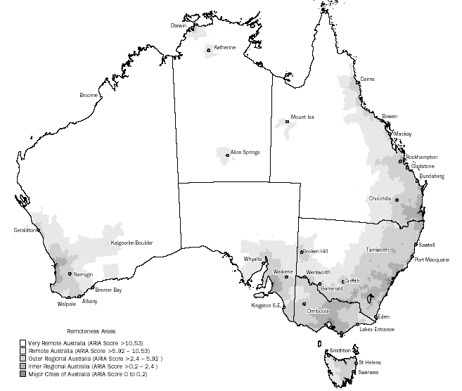
3 ARIA in itself does not have a spatial unit. The ARIA index has been interpolated to a 1 km grid covering the whole of Australia. However, an average ARIA Score can be calculated for any region, although the larger the spatial unit (in area) the greater the variance of ARIA score from one part of the area to another. In selecting a base spatial unit to define a classification of Remoteness in the ASGC, the ABS selected the Census Collection District (CD) because the CD is the smallest building block of the ASGC and could therefore provide the most precise definition of regions of relative remoteness.
4 The Remoteness Areas are therefore based on Census Collection Districts which have been grouped into broad geographical regions classified according to average ARIA Scores. The Remoteness Areas are: Major Cities of Australia, Inner Regional Australia, Outer Regional Australia, Remote Australia, Very Remote Australia and Migratory. The Migratory classification (areas composed of off-shore, shipping and migratory CDs) has been added to make the structure inclusive of all CDs in Australia. However, Migratory has been excluded from the statistics presented in this publication as people do not record these areas as their residential address when completing administrative forms such as the income tax return.
5 Descriptions and examples of each of the five Remoteness Areas are provided in the table and map below. Detailed information is available in Information Paper: ABS Views on Remoteness, 2001 (cat. no. 1244.0) and Information Paper: Outcomes of ABS Views on Remoteness Consultation, Australia, 2001 (cat. no. 1244.0.00.001).
REMOTENESS STRUCTURE - AUSTRALIAN STANDARD GEOGRAPHICAL CLASSIFICATION
| Remoteness area | Description |  | Examples |
|
| Major cities | Geographic distance imposes minimal restriction upon accessibility to the widest range of goods, services and opportunities for social interaction. | | Sydney, Newcastle, Wollongong, Melbourne, Geelong, Brisbane, Gold Coast, Adelaide, Perth and Canberra. |
| Inner regional | Geographic distance imposes some restriction upon accessibility to the widest range of goods, services and opportunities for social interaction. | | Tamworth, Wagga Wagga (New South Wales), Ballarat, Bendigo (Victoria), Rockhampton, Bundaberg, Gladstone (Queensland), the Adelaide Hills (South Australia), Bunbury (Western Australia), Hobart and Launceston (Tasmania). |
| Outer regional | Geographic distance imposes a moderate restriction upon accessibility to the widest range of goods, services and opportunities for social interaction. | | Broken Hill, Griffith, Gunnedah (New South Wales), Horsham, Swan Hill, Traralgon (Victoria), Roma, Cairns (Queensland), Port Augusta, Mount Gambier (South Australia), Albany (Western Australia), Burnie (Tasmania), and Darwin (Northern Territory). |
| Remote | Geographic distance imposes a high restriction upon accessibility to the widest range of goods, services and opportunities for social interaction. | | Cobar (New South Wales), the northern Wimmera district (Victoria), Charters Towers and Cooktown (Queensland), Port Lincoln (South Australia), the Kalgoorlie gold-fields (Western Australia), parts of the West Coast (Tasmania), Alice Springs, Katherine (Northern Territory). |
| Very remote | Geographic distance imposes the highest restriction upon accessibility to the widest range of goods, services and opportunities for social interaction. | | The far west parts of New South Wales and Queensland, northern South Australia and Western Australia, most of the Northern Territory and Flinders and King Islands in Bass Strait (Tasmania). |
|
MAP: AUSTRALIAN STANDARD GEOGRAPHICAL CLASSIFICATION,
REMOTENESS STRUCTURE AREAS
|
 Print Page
 Print All