FEATURE ARTICLE: MURRAY-DARLING BASIN, 2004–05
The Murray-Darling Basin - 'Australia's fruit bowl' - covers an area 1,450 kilometres long and 1,000 kilometres wide and consists largely of plains rising to the Great Dividing Range on its eastern and southern rim. It includes the Australian Capital Territory, and parts of Queensland, New South Wales, Victoria and South Australia and covers 1,058,800 square kilometres or approximately one-seventh (14%) of the total area of Australia. The three main river systems that make up the Murray-Darling Basin include the Darling River and its tributaries, the Murrumbidgee River, the Lachlan River and Billabong Creek and their tributaries; and the River Murray itself and its tributaries.
An important consequence of the extent of the Murray-Darling Basin is the great range of climatic conditions and natural environments, from the rainforests of the cool and humid eastern uplands, the temperate mallee country of the south-east, the sub-tropical areas of the north-east, to the hot, dry semi-arid and arid lands of the far western plains. Key features of the Basin are its high evaporation rate and large interannual variability of the rainfall. The variability in rainfall is amplified in the annual run-off figures, which are among the most variable in the world.
Although the Murray-Darling Basin normally receives only 6% of Australia's annual rainfall, it utilises about 70% of all water used for agriculture across the nation and accounts for 40% of Australia’s agricultural production.
In 2004-05, higher than average rainfall was recorded in the Murray-Darling Basin overall, mainly due to higher than average rainfall in parts of northern New South Wales in late 2004. However, a comparison of run-off results for 2004-05 with the long-term average run-off shows run-off for 2004-05 being below average in the Murray-Darling Basin (77% of the long-term average). Deep drainage for 2004-05 was also below average in the Murray-Darling Basin, which was 90% of the long-term average annual deep drainage. The reason for this is that the 2004-05 year was preceded by more than five years of below-average rainfall across the eastern states of Australia, leading to very dry catchments. Despite above average rainfall in the Murray-Darling Basin in 2004-05, the dry state of the catchments meant that River Murray inflows for 2004-05 totalled about 4,900 GL - little more than half the average annual inflow - which put the year among the driest 20% on record.
The extended nature of the drought means that River Murray system water reserves have been significantly depleted. In 2004-05, most irrigators experienced a third year with less than full allocations. The pressure on irrigation communities has been immense. Large volumes of water have been traded to support high-value industries and commercial arrangements have been made for the advance of additional water purchased from Snowy Hydro.
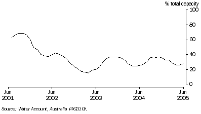
In the Murray-Darling Basin, large dams can store a maximum of 24,339 GL; this comprises nearly a third (29%) of Australia's large dam storage capacity. The water stored in these dams are predominantly used for irrigation in agriculture, but also for hydro-electricity generation, households, manufacturing and mining. A marked decrease in the dam storage levels of the Murray-Darling Basin between January 2002 and March 2003 can be observed, reflecting the height of the drought conditions prevalent at this time (graph 3.16). In 2004-05, storage levels had increased marginally (20-40% of the total capacity), however did not return to pre-2002 levels.
3.16 Large dam storage levels in the Murray-Darling Basin
In addition to large dams, many farm dams exist in the Murray-Darling Basin. These hill-slope farm dams can store up to 2,200 GL in the Basin and can act as a significant interceptor to run-off, potentially reducing stream flow. Reduced stream flow in the rivers can affect the health of many plants and animals that live in or near the river.
The Australian Water Resources 2005 assessment of the river and wetland health in the Murray-Darling Basin found :
- 10% of river length was identified as severely impaired, having lost at least 50% of the types of aquatic invertebrates expected to occur there
- more than 95% of the river length assessed in the Murray-Darling Basin had an environmental condition that was degraded and 30% was substantially modified from the original condition
- most reaches in the central and western part of the Murray-Darling Basin were moderately modified
- all groups of reaches in the Basin had disturbed catchments and modified water quality
- many parts of the Basin were threatened by multiple stresses, principally land use changes, damaged riparian vegetation, poor water quality, increased bedload, and modified hydrology.
In 2004-05, only 6% of Australia’s run-off came from the Murray-Darling Basin. When aggregated, regional water consumption figures for the Water Management Areas in the Murray-Darling Basin show water use in the Basin accounted for about half of Australia’s total water consumption in 2004-05.
 Print Page