|
|
MARINE AND COASTAL WATERS
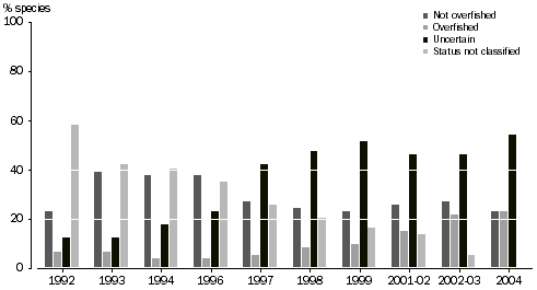
Australia’s coastal and marine regions support a large variety of species, many of which are only found in this country’s waters. Since 1992, amongst the 74 species that are in Commonwealth-managed fisheries, interesting trends in stock conditions are emerging:
- The number of stocks that are overfished (or where there is inadequate knowledge to make a decision) has steadily increased, and is now at a record high level of 23% (17 species).
- The number of primary stocks or species classified not overfished declined substantially in 1997, but has remained generally stable since then.
- The number classified uncertain has increased from a mean (average) of 13 species in 1993–96 to a mean of 36 in 1998–2004. Much of the increase is from stocks, not previously assessed, that on the first assessment were classified uncertain.
The number of species classified has increased during the decade; nevertheless, some species or stocks assigned lower priority and many by-product species, remain unclassified. The fisheries encompassed in the table do not include those where state/territory Government agencies have primary management responsibility, for example, the Norfolk Island Fishery.
STATUS OF FISH STOCKS MANAGED BY THE AUSTRALIAN GOVERNMENT
STATUS OF FISH STOCKS MANAGED BY THE AUSTRALIAN GOVERNMENT |
|
 | Not overfished | Overfished | Uncertain | Status not classified |
|
| 1992 | 17 | 5 | 9 | 43 |
| 1993 | 29 | 5 | 9 | 31 |
| 1994 | 28 | 3 | 13 | 30 |
| 1996 | 28 | 3 | 17 | 26 |
| 1997 | 20 | 4 | 31 | 19 |
| 1998 | 18 | 6 | 35 | 15 |
| 1999 | 17 | 7 | 38 | 12 |
| 2000(a) | 19 | 11 | 34 | 10 |
| 2002(b) | 20 | 16 | 34 | 4 |
| 2004 | 17 | 17 | 40 | 0 |
|
(a) For financial year 2000–01.
(b) For financial year 2002–03.
Source: Bureau of Rural Sciences, Fishery Status Report, 2004. |
MARINE PARKS AND PROTECTED AREAS, AUSTRALIA AND EXTERNAL TERRITORIES
Efforts to preserve Australia’s marine environment include the establishment of a system of protected areas and guidelines to select and manage protected areas. Protected Areas are not the only mechanism for conserving biodiversity but they are an important element of the overall approach.
In 1994, Australia adopted the World Conservation Union (IUCN) definition of a protected area and the internationally recognised IUCN six level system of categories used to describe the management intent as basis for documenting Australia's various types of protected areas. The six categories are:
- Category Ia – Strict Nature Reserve: Protected Area managed mainly for science.
- Category Ib – Wilderness Area: Protected Area managed mainly for wilderness protection.
- Category II – National Park: Protected Area managed mainly for ecosystem conservation and recreation.
- Category III – Natural Monument: Protected Area managed for conservation of specific natural features.
- Category IV – Habitat/Species Management Area: Protected Area managed mainly for conservation through management intervention.
- Category V – Protected Landscape/Seascape: Protected Area managed mainly for landscape/seascape conservation and recreation.
- Category VI – Managed Resource Protected Areas: Protected Area managed mainly for the sustainable use of natural ecosystems.
The IUCN defines a protected area as: "An area of land and/or sea especially dedicated to the protection and maintenance of biological diversity, and of natural and associated cultural resources, and managed through legal or other effective means".
The total number of marine parks and protected areas in Australia and its external territories has increased in number from 148 (and nearly 39 million hectares) in 1997 to 212 in 2004 to encompass nearly 72 million hectares.
MARINE PARKS AND PROTECTED AREAS, Australia and external territories |
|
| Number of marine, national oceanic islands and external territory protected area IUCN | 1997
no. | 1997
ha. | 2002
no. | 2002
ha. | 2004
no. | 2004
ha. |
|
| Category IA | 16 | 2 779 192 | 18 | 15 207 232 | 26 | 14 689 494 |
| Category IB | 0 | 0 | 2 | 202 | 2 | 202 |
| Category II | 16 | 69,080 | 24 | 2 151 068 | 47 | 15 072 908 |
| Category III | 0 | 0 | 0 | 0 | 9 | 345 |
| Category IV | 80 | 586 334 | 106 | 12 045 534 | 99 | 17 347 773 |
| Category V | 7 | 4 716 993 | 0 | 0 | 0 | 0 |
| Category VI | 23 | 35 426 842 | 38 | 35 236 024 | 29 | 24 715 160 |
| TBA / category not specified | 6 | 46 910 | 0 | 0 | 0 | 0 |
| | | | | | |
| Total | 148 | 38 908 358 | 188 | 64 640 060 | 212 | 71 825 882 |
|
| Source: Department of the Environment and Heritage, Summary of Protected Areas http://www.deh.gov.au/parks, last viewed 14 July 2006. |
|
SIZE AND DENSITY CHANGES IN COASTAL POPULATION
Pressures on coastal ecosystems are increasing due to rising population and the ongoing demand for, and increasing access to, tourist and recreation facilities in these areas. Developments such as marinas, dredging lagoon channels and beach groynes all degrade coastal habitats and affect ecosystems.
Australia’s estimated resident population at June 2005 was 20.3 million, an increase of 237,100 people compared with June 2004. This represents an annual growth rate of 1.2%, the same as the average annual growth rate for the five years to June 2005.
All states and territories experienced population growth in 2004–05, with the largest increases occurring in Queensland (up 75,900 people), Victoria (up 59,400 people) and New South Wales (up 53,500 people).
In each state and territory, the areas with the largest or fastest population growth tended to be outer suburbs, inner cities and certain regional centres, especially along the coast.
The largest growth outside capital cities occurred in coastal Australia. Most of the growth in coastal regions is from internal migration as people from inland areas and from larger cities move to the coast – a phenomenon that has been described as “sea change”.
In Australia's coastal regions, the largest increase in population between 2000 and 2005 occurred in Gold Coast-Tweed region, up by an average 14,500 people per year (or 3.3% per year). Mandurah, to the south of Perth, recorded the fastest growth over the same period with an average growth rate of 5.1% per year. This growth was also faster than any capital city. Hervey Bay experienced the second fastest growth (up 4.3% per year) followed by the Sunshine Coast (3.5% per year).
SIZE AND DENSITY CHANGES IN COASTAL POPULATION |
|
| Area(b) | Estimated Resident Population 1996 | Estimated Resident Population 2001 | Estimated Resident Population 2004 (p) | Population change 1996-2001 | Population change (c)
2001-2004(p) |
| '000 km˛ | ‘000 | ‘000 | ‘000 | % | % |
|
| All coastal areas (a) | 2 163.1 | 7 482.0 | 7 971.7 | 8 283.5 | 1.3 | 1.3 |
| Coastal areas excl. capital cities | 2 149.3 | 2 977.7 | 3 193.4 | 3 339.6 | 1.4 | 1.5 |
| Coastal areas within capital cities | 13.8 | 4 504.4 | 4 778.3 | 4 943.9 | 1.5 | 0.7 |
| | | | | | |
| Australia | 7 705.3 | 18 310.7 | 19 413.2 | 20 111.3 | 1.2 | 1.2 |
|
Note: Many SLAs extend inland for large distances.
(a) Coastal areas are all Statistical Local Areas (SLAs) with a boundary adjoining the sea, including those with boundaries adjoining harbours and rivers.
(b) Based on 2004 Australian Standard Geographic Classification boundaries.
(c) Average annual growth rate.
(p) Provisional numbers.
Source: Data available on request from ABS. |
|
|
|
 Print Page
 Print All