This page was updated on 23 Nov 2012 to include the disclaimer below. No other content in this article was affected.
DISCLAIMER:
Users are warned that historic issues of this publication may contain language or views which, reflecting the authors' attitudes or that of the period in which the item was written, may be considered to be inappropriate or offensive today.
LANDFORMS AND THEIR HISTORY
This article has been contributed by Professor Cliff OIlier. University of New England.
Australia is the lowest, flattest, and, apart from Antarctica, the driest of the continents. Unlike Europe and North America, where much of the landscape dates back to 20,000 years ago when great ice sheets retreated, the age of landforms in Australia is generally measured in many millions of years. This fact gives Australia a very distinctive physical geography.
The continent can be divided into three parts - the Western Plateau, the Central Lowlands and the Eastern Highlands.
The Western Plateau consists of very old rocks (some over 3,000 million years old), and much of it has existed as a landmass for over 500 million years. Several parts have individual 'plateau' names (e.g. Kimberley, Hammersley, Arnhem Land, Yilgarn). In the Perth area, younger rocks along a coastal strip are separated from the rest by the Darling Fault escarpment. The Nullarbor Plain is virtually an uplifted sea floor, a limestone plain of Miocene age (about 25 million years).
The Central Lowlands stretch from the Gulf of Carpentaria through the Great Artesian Basin to the Murray-Darling Plains. The Great Artesian Basin is filled with sedimentary rocks which hold water that enters in the wetter Eastern Highlands.
Much of the centre of Australia is flat, but there are numerous ranges (e.g. Macdonnels, Musgrave) and some individual mountains of which Ayers Rock (Uluru) is the best known. Faulting and folding in this area took place long ago, the area was worn to a plain, the plain uplifted and then eroded to form the modern ranges on today's plain. In looking at Ayers Rock the remarkable thing is not how it got there, but that so much has been eroded from all around, leaving it there.
In the South Australian part of the Central Lowlands fault movements are more recent, and the area can be considered as a number of blocks that have been moved up and down to form a series of 'ranges' (Mt Lofty, Flinders Ranges) and 'hills' (such as the Adelaide Hills), with the downfaulted blocks occupied by sea (e.g. Spencer Gulf) or lowlands including the lower Murray Plains.
The Eastern Highlands rise gently from central Australia towards a series of high plateaus, and even the highest part around Mt Kosciusko (2,230 m) is part of a plateau. There are a few younger faults and folds, such as the Lake George Fault near Canberra, and the Lapstone Monocline near Sydney.
Some plateaus in the Eastern Highlands are dissected by erosion into rugged hills, and the eastern edges of plateaus tend to form high escarpments. Many of these are united to form a Great Escarpment that runs from northern Queensland to the Victorian border. Australia's highest waterfalls (Wollombi on the Macleay, Wallaman Falls on a tributary of the Herbert, Barron Falls near Cairns, and Wentworth Falls in the Blue Mountains) all occur where rivers flow over the Great Escarprnent. For most of its length the Great Divide (separating rivers flowing to Central Australia from rivers flowing to the Pacific) runs across remarkably flat country dotted with lakes and airstrips, and there is no 'Great Dividing Range'. In eastern Victoria, however, the old plateau has been eroded into separate High Plains (such as Dargo High Plain), mostly lying south of the Divide which here runs across rugged country.
The present topography results from a long landscape history which can conveniently be started in the Permian, about 290 million years ago, when much of Australia was glaciated by a huge ice cap. After the ice melted, parts of the continent subsided and were covered with sediment to form sedimentary basins such as the Great Artesian Basin. By early Cretaceous times, about 140 million years ago, Australia was already so flat and low that a major rise in sea level divided it into three landmasses as the shallow Cretaceous sea spread over the land.
In the following Tertiary times Australia can be regarded as a landscape of broad swells varied by a number of sedimentary basins (Murray, Gippsland, Eucla, Carpentaria, Lake Eyre and other basins). These slowly filled up and some are now sources of coal or oil. The Eastern Highlands were uplifted about this time.
Throughout the Tertiary, volcanoes erupted in eastern Australia. Some individual volcanoes were the size of modern Vesuvius, and huge lava plains covered large areas. Volcanic activity continued up to a few thousand years ago in Victoria and Queensland. Australia's youngest volcano is Mt Gambler in South Australia. about 6,000 years old.
Between about 55 and 10 million years ago Australia drifted across the surface of the earth as a plate, moving north from a position once adjacent to Antarctica. There have been many changes in the climate of Australia in the past, but oddly these are not due to changing latitude. Even when Australia was close to the South Pole the climate was warm and wet, and this climate persisted for a long time despite changes in latitude. It was probably under this climate that the deep weathered, iron-rich profiles that characterise much of Australia were formed. Aridity only seems to have set in after Australia reached its present latitude, and the northern part was probably never arid.
Today a large part of Australia is arid or semi-arid. Sand dunes are mostly longitudinal, following the dominant wind directions of a high pressure cell. The dunes are mostly fixed now. Stony deserts or gibber plains (covered with small stones or 'gibbers') are areas without a sand cove and occupy a larger area than the dunefields. Salt lakes occur in many low positions, in places following lines of ancient drainage. They are often associated with lunettes, dunes formed on the downwind side of lakes. Many important finds of Aboriginal pre-history have been made in lunettes. Despite the prevalence of arid conditions today, real aridity seems to be geologically young, with no dunes or salt lakes older than a million years.
The past few million years were notable for the Quaternary ice age. There were many glacial and interglacial periods (over 20) during this time, the last glacial about 20,000 years ago. In Tasmania there is evidence of three different glaciations - the last glaciation, one sometime in the Quaternary, and one in the Tertiary. In mainland Australia there is evidence of only the last glaciation and the ice then covered only 25 square kilometres, in the vicinity of Mt Kosciusko.
The broad shape of Australia is caused by earth movements, but most of the detail is carved by river erosion. Many of Australia's rivers drain inland, and while they may be eroding their valleys near their highland sources, their lower courses are filling up with alluvium, and the rivers often end in salt lakes which are dry for most of the time. Other rivers reach the sea, and have dissected a broad near-coast region into plateaus, hills and valleys. Many of the features of the drainage pattern of Australia have a very long history, and some individual valleys have maintained their position for hundreds of millions of years. The salt lakes of the Yilgarn Plateau in Western Australia are the remnants of a drainage pattern that was active before continental drift separated Australia from Antarctica.
During the last ice age, sea level was over 100 metres lower than it is today, and rivers cut down to this low level. When sea level rose again the lower valleys were drowned. Some make fine harbours (e.g. Sydney Harbour), whilst others have tended to fill with alluvium, making the typical lowland valleys around the Australian coast.
Coastal geomorphology is also largely the result of the accumulation of sediment on drowned coasts. in some areas, such as Ninety Mile Beach (Victoria) or the Coorong (South Australia), there are simple accumulation beaches. In much of the east there is a characteristic alternation of rocky headland and long beach, backed by plains filled with river and marine sediments.
PALAEOGEOGRAPHIC RECONSTRUCTION MAPS: 300 MILLION YEARS AGO TO PRESENT DAY
(Source: Bureau of Mineral Resuorces, Geology and Geophysics)
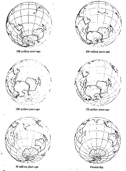 These maps have been produced on an orthographic projection with a 20 degree graticule spacing.
All six maps have a centre of view at a location of 83 degress East longitude and 45 degress South latitude.
These maps have been produced on an orthographic projection with a 20 degree graticule spacing.
All six maps have a centre of view at a location of 83 degress East longitude and 45 degress South latitude.
The offshore shape of Australia, revealed in isobath contours, results mainly from the pattern of break-up of the super-continent of which Australia was once a part. There is a broad continental shelf around most of Australia, bounded by a steeper continental slope, except in New South Wales where the continental shelf is very narrow. The Queensland coast is bounded by a broad plateau on which the Great Barrier Reef has grown in only the last two million years. In South Australia the continental shelf is grooved by submarine canyons.
The Australian landforms of today are thus seen to result from long-continued processes in a unique setting, giving rise to typical Australian landscapes, which in turn provide the physical basis for the distribution and nature of biological and human activity in Australia.
 Print Page