GLOSSARY
Average annual rate of growth
The average annual growth rate is calculated as a percentage using the formula:
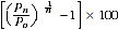
where P0 is the population at the start of the period, Pn is the population at the end of the period and n is the length of the period between Pn and P0 in years.
Capital city
Refers to the capital city Statistical Divisions of states and territories as defined in Australian Standard Geographical Classification (ASGC) (cat. no. 1216.0).
Census count
The Census of Population and Housing enumerates persons on the basis of where they were located on census night. Characteristics of households are only available according to place of enumeration. The census also compiles information on people according to their place of usual residence. This information is coded to Statistical Local Area. This means that census counts of people can be produced according to their location on census night as well as their place of usual residence.
Commonwealth Electoral Division (CED)
Commonwealth Electoral Divisions (CEDs) are approximations of Australian Electoral Commission (AEC) Electoral Divisions. These electoral divisions are legally prescribed for the purpose of returning one member to the House of Representatives, Australia's Federal Lower House of Parliament. The AEC's electoral division boundaries come into effect after a federal election and are current until the next election. As a result of the timing of a federal election soon after the scheduled release of 2006 Census data, two CED classifications were defined for the 2006 Census. On Census night (8 August 2006), the electoral division boundaries in effect were those dating from the previous federal election held on 9 October 2004. The CED boundaries for that election are called CED 2004. The next federal election was held on 24 November 2007. The CEDs based on the boundaries in effect for that election are called CED 2007. Data released in this product is based on CED 2007. Further information on CEDs can be found in Statistical Geography: Volume 2 - Census Geographic Areas, Australia, 2006 (cat. no. 2905.0).
Estimated resident population (ERP)
The official measure of the population of Australia is based on the concept of usual residence. It refers to all people, regardless of nationality or citizenship, who usually live in Australia, with the exception of foreign diplomatic personnel and their families. It includes usual residents who are overseas for less than 12 months. It excludes overseas visitors who are in Australia for less than 12 months.
Greater Capital City Statistical Area (GCCSA)
Greater Capital City Statistical Areas (GCCSAs), as defined in the Australian Statistical Geography Standard (ASGS) (cat. no. 1270.0.55.001), represent the socio-economic extent of each of the eight state and territory capital cities. This means that the greater capital city boundary includes people who regularly socialise, shop or work within the city, but live in the small towns and rural areas surrounding the city. It does not define the built up edge of the city. Within each state and territory, the area not defined as being part of the greater capital city is represented by a Rest of State region.
Intercensal error
Intercensal error is the difference between two estimates at 30 June of a census year population: the first based on the latest census and the second arrived at by updating the 30 June estimate of the previous census year with intercensal components of population change which do not take account of information available from the latest census. For further information see Population Estimates: Concepts Sources and Methods, 2009 (cat. no. 3228.0.55.001).
Local Government Area (LGA)
Local Government Areas (LGAs) are the spatial units which represent the geographical areas of incorporated local government councils. The ABS has broadened the categories of legislation used to define LGAs for statistical purposes to include the Indigenous Council areas in the states and Northern Territory. The LGA structure covers only incorporated areas of Australia, which are legally designated parts of states and territories over which incorporated local governing bodies have responsibility.
Net undercount
The difference between the actual census count (including imputations) and an estimate of the number of people who should have been counted in the census. The estimate is based on the Post Enumeration Survey (PES) conducted after each census. For a category of person (e.g. based on age, sex and state of usual residence), net undercount is the result of Census undercount, overcount, misclassification and imputation error.
Population growth
For Australia, population growth is the sum of natural increase and net overseas migration. For states and territories, population growth also includes net interstate migration. At the sub-state level, population growth is estimated by the methods outlined in the Explanatory Notes.
Population growth rate
Population change over a period as a proportion (percentage) of the population at the beginning of the period.
Post Enumeration Survey (PES)
The Census Post Enumeration Survey (PES) is a household survey conducted three to four weeks after the Census. The PES allows the ABS to estimate the number of people missed in the Census and the number counted more than once. Usually more people are missed than are counted more than once in Australia, leading to a net undercount. Results from the PES contribute to a more accurate calculation of the estimated resident population (ERP).
Remainder of state or territory
The aggregation of all Statistical Divisions (SDs) within a state or territory other than its capital city SD (see Major Statistical Regions in Australian Standard Geographical Classification (ASGC) (cat. no. 1216.0)).
Remoteness Area (RA)
Remoteness Areas (RAs) represent an aggregation of non-contiguous geographical areas which share common characteristics of remoteness, based on the Accessibility/Remoteness Index of Australia (ARIA). For more information see the 2006 edition of the Australian Standard Geographical Classification (ASGC) (cat. no. 1216.0)).
State Electoral Division (SED)
State Electoral Divisions are approximations of the state electoral districts legally prescribed for the purpose of returning one or more members to the State or Territory Lower Houses of Parliament. Boundaries are based upon the state electoral districts current on Census Night 8 August, 2006. The exception is Victoria, where boundaries effective for their state election held on 25 November, 2006 were used because of the proximity of the dates. Further information on SEDs can be found in Statistical Geography: Volume 2 - Census Geographic Areas, Australia, 2006 (cat. no. 2905.0).
Statistical Area Level 2 (SA2)
Statistical Areas Level 2 (SA2s) are general-purpose medium-sized areas. Their aim is to represent a community that interacts together socially and economically. SA2s generally have a population range of 3,000 to 25,000 people, and have an average population of 10,000.
Statistical Area Level 3 (SA3)
Statistical Areas Level 3 (SA3s) are designed to provide a regional breakdown of Australia. In the major cities, they represent the area serviced by a major transport and commercial hub. In regional areas, they represent the area serviced by regional cities with a population over 20,000 people and in outer regional and remote areas, they represent areas which are widely recognised as having a distinct identity and have similar social and economic characteristics.
Statistical Area Level 4 (SA4)
Statistical Areas Level 4 (SA4s) are designed for the output of labour force data and reflect labour markets within each State and Territory. SA4s generally have a minimum population of 100,000 people. In regional areas, SA4s tend to have populations of between 100,000 and 300,000 people while in metropolitan areas, SA4s tend to have larger populations (300,000 to 500,000 people).
Statistical District (S Dist)
Statistical Districts (S Dists) consist of selected, significant, predominantly urban areas in Australia which are not located within a Capital City Statistical Division. S Dists enable comparable statistics to be produced about these selected urban areas.
Statistical Division (SD)
Statistical Divisions (SDs) consist of one or more Statistical Subdivisions (SSD). These are designed to be relatively homogeneous regions characterised by identifiable social and economic units within the region, under the unifying influence of one or more major towns or cities.
Statistical Local Area (SLA)
Statistical Local Areas (SLAs) are in most cases identical with, or have been formed from a division of, whole Local Government Areas (LGAs). In other cases they represent unincorporated areas. In aggregate, SLAs cover the whole of a state or territory without gaps or overlaps. In some cases legal LGAs overlap Statistical Subdivision boundaries and therefore comprise two SLAs (Part A and Part B).
Statistical Subdivision (SSD)
Statistical Subdivisions (SSDs) are of intermediate size, between Statistical Local Areas and Statistical Divisions. In aggregate, they cover the whole of Australia without gaps or overlaps. They are defined as socially and economically homogeneous regions characterised by identifiable links between the inhabitants. In the non-urban areas, an SSD is characterised by identifiable links between the economic units within the region, under the unifying influence of one or more major towns or cities.
Usual residence
Usual residence within Australia refers to that address at which the person has lived or intends to live for a total of six months or more in a given reference year.
 Quality Declaration
  Print Page
 Print All