EXPLANATORY NOTES
INTRODUCTION
1 This product contains estimates of the resident population of Local Government Areas (LGAs) and states and territories of Australia. These estimates plus Statistical Local Areas (SLAs), Statistical Division (SDs), Statistical Subdivisions (SSDs) and Statistical Districts are also provided and can be found in the Downloads tab of this release.
2 To meet the conflicting demands for accuracy and timeliness there are several versions of sub-state/territory population estimates. Preliminary estimates are normally available nine months after the reference date (i.e. March), revised estimates twelve months later and rebased and final estimates after the following census. The estimates in this product are final for 2001, preliminary rebased for 2002 to 2006, based on results of the 2006 Census of Population and Housing, and preliminary for 2007. The final 2006 Census-based SLA and LGA estimates for 2002 through to 2006, together with the first revision of 2007 are intended to be released in August 2008.
ESTIMATED RESIDENT POPULATION - AUSTRALIA
3 Estimated resident populations (ERPs) are official estimates of the Australian population, which link people to a place of usual residence within Australia. Usual residence is that place where each person has lived or intends to live for six months or more from the reference date for data collection.
4 Estimates of the resident population are based on census counts by place of usual residence (excluding overseas visitors in Australia), with an allowance for net census undercount, to which are added the number of Australian residents estimated to have been temporarily overseas at the time of the census.
5 Population estimates for Australia and the states and territories are updated by adding to the estimated population at the beginning of each period the components of natural increase (births minus deaths, on a usual residence basis) and net overseas migration. For the states and territories, account is also taken of estimated interstate movements involving a change of usual residence.
6 After each census, estimates for the preceding intercensal period are finalised by incorporating an additional adjustment (intercensal discrepancy) to ensure that the difference between the ERPs at the two respective census dates agrees with the total intercensal change.
7 A more detailed explanation of the concept of ERP, as adopted by the ABS for official population estimates, is contained in Demographic Estimates and Projections: Concepts, Sources and Methods (cat. no. 3228.0), ABS website <www.abs.gov.au>.
ESTIMATION OF SLA-BASED POPULATIONS
8 In Australia, the SLA is the base spatial unit used to collect and disseminate statistics other than those collected from the Population Censuses. In non-census years, the SLA is the smallest unit defined in the Australian Standard Geographical Classification (ASGC). In aggregate, SLAs cover the whole of Australia without gaps or overlaps. Populations for SLAs are estimated as at 30 June each year. Population estimates for LGAs and other regions are built up from SLA-level estimates.
9 The ERP as at census date for each SLA is calculated based on usual residence census counts, excluding overseas visitors in Australia, with an allowance for net census undercount and the number of residents temporarily overseas at the census date. The estimates of net undercount are apportioned to SLAs based on age, sex, Indigenous status, state and territory, and (aside from the ACT) capital city/balance of state. The number of residents temporarily overseas (RTOs) on census night is estimated based on coding addresses of residence to SLA from a sample of incoming passenger cards. For some areas, demographic adjustments are made. As the census is held on a date other than 30 June (the 2006 Census was held on 8 August), further adjustments taking into account births, deaths and migration for the intervening period are made to obtain the ERP at 30 June. For the preliminary rebased ERP at 30 June 2006, estimates are made of these RTOs and the 30 June to 8 August components. The RTOs and 30 June to 8 August components are finalised for final rebasing of the ERP at 30 June 2006.
10 For post-censal years, the absence of migration data at the SLA level means that it is not possible to estimate SLA populations by taking into account natural increase and net migration. Instead, ERPs for most SLAs are calculated using a mathematical model, where relationships are established between changes in population and changes in indicators between the two most recent censuses for groups of SLAs. The choice of indicators varies across the states and territories, depending on availability and indicative ability, and includes dwelling approvals, Medicare enrolments and counts of people on the Australian Electoral Roll. Changes in these indicators are then used to estimate changes in the population of each area since the last census. In areas where indicator data is unreliable and migration can be assumed to insignificant, population change since the previous census may be estimated by adding estimates of natural increase (births minus deaths) since the previous census. In some very small areas population change since the previous census may be assumed to be zero in the absence of all reliable indicator data for these areas. All estimates are scrutinised and validated by population analysts. Local knowledge, including that advised by local governments, may be used to adjust the figures for particular SLAs. Estimates at SLA level are constrained to state/territory population estimates.
11 In census years, both preliminary estimates (derived from updating the ERPs from the previous census) and rebased estimates (based on the current census) are prepared. Differences between these two sets of estimates are referred to as intercensal errors. Rebased estimates of SLA populations for previous intercensal years are based on estimates derived by apportioning the intercensal error evenly across the five years, while constraining the SLA level estimates to state/territory estimates. For example, rebased 2002 to 2005 estimates were derived by adding one-fifth of the 2006 intercensal error to the previous estimates of the 2002 population, two-fifths to the previous estimate of the 2003 population, and so on.
ACCURACY OF SLA-BASED POPULATION ESTIMATES
12 An indication of the accuracy of ERPs can be gauged by assessing the size and direction of the intercensal errors. For Australia, the preliminary June 2006 ERP under-estimated the preliminary rebased June 2006 ERP by 0.46% (-96,000 people). For the states/territories, the intercensal errors based on the preliminary rebased 2006 ERP ranged from -1.89% (Northern Territory) to +0.15% (New South Wales).
13 Summary statistics of the absolute values of these errors can be used to assess the accuracy of a number of population estimates. The average absolute value of the intercensal errors for the preliminary rebased 2006 series of SLA estimates (excluding areas with an ERP less than 500) was 3.75%, a decrease on the 2001 average of 3.82%. For LGAs, the preliminary rebased 2006 average absolute intercensal error (excluding areas with an ERP less than 500) was 3.54%, a decrease on the 2001 average of 3.62%.
14 Average absolute intercensal errors for the preliminary rebased series of 2006 LGA estimates decreased with increasing population size; that is, LGAs with large populations recorded the smallest percentage errors while small LGAs recorded the largest percentage errors.
Average absolute intercensal error, preliminary - Australia - 30 June 2006 |
|  |
| Number
of LGAs | Average absolute intercensal error | |
| Size of LGA (people) | no. | % | |
| |
| Under 500 | 23 | 13.6 | |
| 500 to 1,999 | 89 | 6.5 | |
| 2000 to 4,999 | 94 | 5.4 | |
| 5,000 to 9,999 | 85 | 3.1 | |
| 10,000 to 19,999 | 94 | 3.0 | |
| 20,000 to 49,999 | 92 | 2.1 | |
| 50,000 and over | 127 | 1.9 | |
| |
15 The preliminary rebased 2006 intercensal error for total capital city Statistical Divisions was -0.58% (-76,000 people) and for the remainder of Australia was -0.27% (-20,000). The proportion of the Australian population estimated to be living in capital city Statistical Divisions based on the preliminary 2006 estimate was 63.55%, compared with 63.62% based on the preliminary rebased 2006 figure, an intercensal error of -0.07 percentage points; the corresponding error for 2001 was +0.41 percentage points.
16 In recognition of the inherent inaccuracy involved in population estimation, in general population figures less than 1,000 in the text and accompanying summary tables are rounded to the nearest ten, figures over 1,000 are rounded to the nearest hundred, and figures over 1 million are rounded to the nearest 10,000 or 100,000. While unrounded figures are provided in the spreadsheets, accuracy to the last digit is not claimed and should not be assumed. Percentage change in population is based on unrounded numbers.
INTERPRETATION OF LGA RANKINGS
17 The spreadsheet called 'Population Estimates by Local Government Area, 2001 to 2007' (under the Downloads tab) has LGAs ranked within states and territories according to both ‘largest’ and ‘fastest’ preliminary growth, identifying areas in Australia currently experiencing significant changes in population size. Largest growth is based on the absolute change in population between June 2006 and June 2007, while fastest growth is based on the rate of change in population (that is, the percentage change in population) for the same period. LGAs with populations of less than 2,000 people at June 2006 have been excluded from the fastest growth rankings.
18 Due to the inherent imprecision of small area population estimates, rankings should be considered indicative of relative growth between LGAs within each state and territory, not definitive.
AVERAGE ANNUAL RATE OF GROWTH
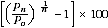
19 The average annual growth rate is calculated as a percentage using the formula below, where P0 is the population at the start of the period, Pn is the population at the end of the period and n is the length of the period between Pn and P0 in years.
SUB-SLA POPULATIONS
20 Census Collection Districts (CDs) are designed for use in census years for the collection and dissemination of census data. In aggregate, CDs cover the whole of Australia without gaps or overlaps. In census years, one or more CDs form an SLA.
21 To provide some indication of estimated resident population below the SLA level, the ABS prepares population estimates for CDs. These estimates can be aggregated to form population estimates for regions such as Remoteness Areas, and may be used in the calculations of population estimates for SLAs created after the 2006 Census.
22 Population estimates at the CD level as at 30 June of a census year are compiled by apportioning the population estimate for each SLA across the CDs within the SLA, using census usual residence counts. In subsequent years, the 30 June population estimates for SLAs are apportioned across CDs by taking into account population change implied by indicator data in each CD since the census year. For SLAs involved in boundary changes, each CD may be assigned to one or more SLAs, and for CDs which fall within more than one SLA an estimate is made of the split of the CD's population and dwellings across SLAs. The CD populations within each SLA are then adjusted (on a pro-rata basis) to add to the SLA population.
CENTRE OF POPULATION
23 The centre of population is one measure used to describe the spatial distribution of a population. The method used to calculate centres of population in this product is based on the centroid and population of each SLA. To calculate the centre of population for an area, the latitude and longitude coordinates of the centroid of each SLA in that area are multiplied by the SLA's estimated resident population to obtain weighted latitudes and longitudes for each SLA. These are summed to obtain a weighted latitude and longitude coordinate for the area, then divided by the total population of the area to obtain a single latitude and longitude coordinate.
24 Due to the inherent imprecision in small area estimates, the centre of population should be considered indicative only of the distribution of population, and cannot be ascribed to an exact location. The use of different geographical level data could result in different centres of population.
SERVICE POPULATIONS
25 Service population estimates are a different measure of population. They take into account seasonal and itinerant populations which are not included in the ERP. More information about the concept of service populations is available in Chapter 6 of Information Paper: Population Concepts, 2008 (cat. no. 3107.0.55.006). Currently the ABS does not produce service population estimates but has published two working papers which investigate the feasibility of producing such estimates: Demography Working Paper 1996/4 - When ERPs aren't Enough (cat. no. 3112.0) and Demography Working Paper 1999/3 - Service Population Pilot Study: An Investigation to Assess the Feasibility of Producing Service Population Estimates for Selected LGAs (cat. no. 3117.0).
AUSTRALIAN STATISTICAL AREAS
26 This publication contains data presented according to the 2007 edition of the Australian Standard Geographical Classification (ASGC), which refers to boundaries as defined at 1 July 2007. Under this classification, statistical areas are defined as follows:
- Local Government Areas (LGAs). These areas are the spatial units which represent the geographical areas of incorporated local government councils. The ABS has broadened the categories of legislation used to define local government areas for statistical purposes to include the Indigenous Council areas in the states and Northern Territory. The LGA Structure covers only incorporated areas of Australia, which are legally designated parts of states and territories over which incorporated local governing bodies have responsibility.
- Statistical Local Areas (SLAs). These areas are, in most cases, identical with, or have been formed from a division of, whole LGAs. In other cases they represent unincorporated areas. In aggregate, SLAs cover the whole of a state or territory without gaps or overlaps. In some cases legal LGAs overlap Statistical Subdivision boundaries and therefore comprise two or three SLAs (Part A, Part B and, if necessary, Part C).
- Statistical Subdivisions (SSDs). These are of intermediate size, between SLAs and SDs. In aggregate, they cover the whole of Australia without gaps or overlaps. They are defined as socially and economically homogeneous regions characterised by identifiable links between the inhabitants. In the non-urban areas an SSD is characterised by identifiable links between the economic units within the region, under the unifying influence of one or more major towns or cities.
- Statistical Divisions (SDs). These consist of one or more SSDs. The divisions are designed to be relatively homogeneous regions characterised by identifiable social and economic units within the region, under the unifying influence of one or more major towns or cities. There were some major changes made to the SD structure in south-east Queensland in the 2006 edition of the ASGC.
- Statistical Districts. These consist of selected, significant, predominantly urban areas in Australia which are not located within a Capital City SD. Statistical Districts enable comparable statistics to be produced about these selected urban areas.
27 LGAs are proclaimed by various state and territory government authorities and changes are gazetted throughout the year. Presently, LGAs are used as the base on which SLAs are defined for the ASGC. Because this definition process takes time, some LGAs gazetted during the year leading up to an ASGC edition are not processed in time for inclusion in that edition, and are instead included in a later edition.
28 The Remoteness Structure is defined only in census years and its purpose is to classify CDs which share common characteristics of remoteness into broad geographical regions called Remoteness Areas (RAs). Within a state or territory, each RA represents an aggregation of non-contiguous geographical areas which share common characteristics of remoteness. As characteristics of remoteness are determined in the context of Australia as a whole, not all RAs are represented in each state or territory. The delimitation criteria for RAs are based on the Accessibility/Remoteness Index of Australia (ARIA), which measures the remoteness of a point based on the physical road distance to the nearest Urban Centre in each of the five size classes.
29 Further information concerning statistical areas is contained in Australian Standard Geographical Classification, 2007 (cat. no. 1216.0).
CALCULATION OF AREAS
30 The area figures used in this issue are based upon the SLA level of the Australian Standard Geographical Classification, 2007 edition. The areas of the SLAs were calculated using ABS standard Geographic Information Systems software from the digital boundaries of this ASGC edition. Higher level spatial unit area figures are aggregations of the relevant SLA areas. The area of each SLA is included in the SLA spreadsheets accompanying this publication.
MAPS
31 A complete series of SLA maps is available in Australian Standard Geographical Classification, 2007 (cat. no. 1216.0).
ACKNOWLEDGMENT
32 ABS publications draw extensively on information provided freely by individuals, businesses, governments and other organisations. Their continued cooperation is very much appreciated; without it, the wide range of statistics published by the ABS would not be available. Information received by the ABS is treated in strict confidence as required by the Census and Statistics Act 1905.
RELATED RELEASES
33 Other ABS releases that are freely available on the ABS website <www.abs.gov.au> and may be of interest to users of this product include:
34 Current publications and other products released by the ABS are listed in the
Catalogue of Publications and Products (cat. no. 1101.0). The Catalogue is available from any ABS office or the ABS website <www.abs.gov.au>. The ABS also issues a daily Release Advice on the website which details products to be released in the week ahead.
35 As well as the statistics included in this and related publications, additional information is available from the ABS website <www.abs.gov.au> by selecting Themes then Demography.
 Quality Declaration
  Print Page
 Print All