|
|
INTRODUCTION
1 For Australia, this publication contains estimates of the resident population of SLAs, LGAs, SSDs, SDs, Statistical Districts, states and territories, and Australia. For New Zealand, this publication contains estimates of the resident population of Regional Councils, Territorial Authorities and New Zealand.
2 LGAs are ranked within states and territories according to both largest growth (in number) and fastest growth (in percentage terms) between June 2001 and June 2002, allowing this publication to identify, in two ways, areas in Australia with the largest and fastest increases and decreases in population. Largest growth is based on the absolute change in population while fastest growth is based on the rate of change in population.
3 Following the 1992 amendment to the Acts Interpretation Act 1901-1973 to include the Indian Ocean Territories of Christmas Island and Cocos (Keeling) Islands as part of geographic Australia, population estimates at dates commencing from July 1993 include estimates for these two territories. To reflect this change, another category of the state/territory classification was created, known as Other Territories. Other Territories include Jervis Bay Territory, Christmas Island and the Cocos (Keeling) Islands. Prior to July 1993, Jervis Bay Territory was included in estimates for the Australian Capital Territory.
4 To meet the conflicting demands for accuracy and timeliness there are three estimates of sub-state/territory populations. Preliminary estimates are normally available eight months after the reference date (i.e. February), revised estimates a year later and final estimates after the following census. The Australian estimates in this publication are final for 1997 and 2001, based on results of the 2001 Census of Population and Housing. The 2002 estimates are preliminary and have been released in April such that they are based upon the recently available final 2001 estimates rather than preliminary 2001 estimates.
5 In recognition of the inherent inaccuracy involved in population estimation, population figures less than 1,000 in the text and accompanying summary tables are rounded to the nearest ten, figures over 1,000 are rounded to the nearest hundred, and figures over 1 million are rounded to the nearest 100,000. While unrounded figures are provided in the main tables, accuracy to the last digit is not claimed and should not be assumed.
ESTIMATED RESIDENT POPULATION - AUSTRALIA
6 Estimated resident population (ERP) are estimates of the Australian population obtained by adding to the estimated population at the beginning of each period the components of natural increase (on a usual residence basis) and net overseas migration.
7 For the states and territories, account is also taken of estimated interstate movements involving a change of usual residence. After each census, estimates for the preceding intercensal period are revised by incorporating an additional adjustment (intercensal discrepancy) to ensure that the total intercensal increase agrees with the difference between the ERPs at the two respective census dates.
8 Estimates of the resident population are based on census counts by place of usual residence, with an allowance for net census undercount, to which are added the number of Australian residents estimated to have been temporarily overseas at the time of the census. Overseas visitors in Australia are excluded from this calculation.
9 The concept of ERP links people to a place of usual residence within Australia. Usual residence is that place where each person has lived or intends to live for six months or more from the reference date for data collection.
Estimation of sub-state/territory populations
10 In census years the ERP as at 30 June for each Statistical Local Area (SLA)/Local Government Area (LGA) is based on usual residence census counts, with an allowance for net census undercount and the number of residents temporarily overseas at the census date. Overseas visitors in Australia are excluded from this calculation. As the census is held at a date other than 30 June (6 August in both 1991 and 1996, and 7 August in 2001), further adjustments taking into account births, deaths and net migration for the intervening period are made to obtain the ERP at 30 June.
11 For post-censal years, the absence of migration data at the SLA level means that it is not possible to estimate SLA populations by taking into account natural increase and net migration. Instead, ERPs are calculated using a mathematical model. Local knowledge, including that advised by local governments, may be used to adjust the outcome of the model for a particular SLA.
12 In the mathematical model a relationship is established between changes in population and changes in other indicators over the period between the two most recent censuses.
13 The choice of indicators varies across the states and territories, depending on availability, and includes dwelling approvals, electricity connections, Medicare enrolments and drivers' licences. Changes in these indicators are then used to estimate changes in the population of each area since the last census. The choice of indicators also varies across SLAs depending on aspects such as whether the SLA is urban or rural, is growing or declining, and whether the area has a high or low proportion of houses or medium and high density dwellings.
14 For the first time, the Australian Bureau of Statistics has produced ERPs for Queensland Aboriginal Council and Island Council Areas. In previous years, population estimates for these areas were included in the estimates for the LGAs in which they were previously incorporated. Census year ERPs for these areas are based on usual residence census counts, adjusted for net undercount, residents temporarily overseas, natural increase and net migration. As a result of difficulties in measuring small populations, particularly those of Aboriginal and Torres Strait Islander communities, mathematical models have not been used in calculating post-census year ERPs for these areas. Instead, the ERPs are derived using a number of indicators including electoral roll enrolments, housing surveys and school enrolments, with account taken of advice provided by Council representatives and area contacts. Estimates for these areas have also been produced for intercensal years to enable comparisons over time. These were derived by age-cohort interpolation between census year ERPs.
15 A more detailed explanation of the concept of ERP, as adopted by the ABS for official population estimates, is contained in Demographic Estimates and Projections: Concepts, Sources and Methods, Statistical Concepts Library, ABS web site.
16 Service population estimates are a different measure of population. They take into account seasonal itinerant populations which are not included in the ERP. Currently the ABS does not produce service population estimates but two working papers are available which investigate the concept and feasibility of such estimates. The working papers are available on the ABS web site by selecting Themes, then Demography, then ABS Demography Working Papers (numbers 96/4 and 99/3).
ESTIMATED RESIDENT POPULATION - NEW ZEALAND
17 The estimated resident population of New Zealand, and any area of New Zealand, at 30 June in the year of the latest census is based on the latest census usually resident population counts updated for net census undercount, the number of residents temporarily overseas on census night, births, deaths and net migration between census night and 30 June, and reconciliation with demographic estimates at ages 0-9 years.
18 Subsequent national population estimates are produced by updating previous estimates using births, deaths and external migration data for the current quarter.
Subnational population estimates
19 Subnational population estimates are produced annually, as at 30 June. The estimation of subnational resident population uses the same component methodology as is used for estimates of the total national population, but with the addition of an extra component - internal migration between the subnational areas of New Zealand.
20 As no data on current internal migration is available, internal migration is estimated indirectly, using 'symptomatic' data, including building consents, occupancy rates, full-time equivalent employment, numbers of people in institutions (e.g. prisons), armed forces data, and past internal migration (from the most recent intercensal period). This information is supplemented by information from Territorial Authorities and universities. More details are available on request from Chief Demographer, Demography Division, Private Bag 4741, Christchurch, New Zealand.
AUSTRALIAN STATISTICAL AREAS
21 This publication contains data presented according to the 2002 edition of the Australian Standard Geographical Classification (ASGC). Under this classification, statistical areas are defined as follows:
- Legal Local Government Areas (LGAs). These areas are the spatial units which represent the geographical areas of incorporated local government councils and incorporated Community Government Councils (CGCs) where the CGC is of sufficient size and statistical significance. The various types of LGAs are Aboriginal Councils (AC), Areas (A), Boroughs (B), Cities (C), District Councils (DC), Island Councils (IC), Municipalities (M), Regional Councils (RegC), Rural Cities (RC), Shires (S), and Towns (T).
- Statistical Local Areas (SLAs). These geographical areas are, in most cases, identical with, or have been formed from a division of, whole LGAs. In other cases they represent unincorporated areas. In aggregate, SLAs cover the whole of a state or territory without gaps or overlaps. In some cases legal LGAs overlap Statistical Subdivision boundaries and therefore comprise two or three SLAs (Part A, Part B and, if necessary, Part C).�
- Statistical Subdivisions (SSDs). These are of intermediate size, between SLAs and SDs. In aggregate, they cover the whole of Australia without gaps or overlaps. They are defined as socially and economically homogeneous regions characterised by identifiable links between the inhabitants. In the non-urban areas an SSD is characterised by identifiable links between the economic units within the region, under the unifying influence of one or more major towns or cities.
- Statistical Divisions (SDs). These consist of one or more SSDs. The divisions are designed to be relatively homogeneous regions characterised by identifiable social and economic units within the region, under the unifying influence of one or more major towns or cities.
- Statistical Districts. These consist of selected, significant, predominantly urban areas in Australia which are not located within a Capital City SD. Statistical Districts enable comparable statistics to be produced about these selected urban areas.
22 Further information concerning statistical areas is contained in Australian Standard Geographical Classification (ASGC), 2002 (cat. no. 1216.0).
23 For the purposes of this publication, all data refer to bounded areas as defined at 1 July 2002, and as incorporated in the 2002 ASGC.
MAPS
24 A complete series of maps showing the SLAs mentioned in this publication is available in Australian Standard Geographical Classification (ASGC), 2002 (cat. no. 1216.0) and is freely available on the ABS web site by selecting About Statistics.
AVERAGE ANNUAL RATE OF GROWTH
25 The average annual growth rate, r, is calculated as a percentage using the formula:
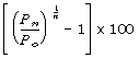
where P0 is the population at the start of the period, Pn is the population at the end of the period and n is the length of the period between Pn and P0 in years.
CALCULATION OF AREAS
26 The area figures quoted in this issue are based upon the SLA level of the Australian Standard Geographical Classification (ASGC), 2002 (cat. no. 1216.0). The areas of the SLAs were calculated using ABS standard Geographic Information Systems software from the digital boundaries of the ASGC 2002. Higher level spatial unit area figures are subtotals of the SLA areas.
ELECTRONIC DATA
27 Annual population estimates at 30 June for all SLAs in Australia are available electronically. This information can be customised to provide data for any choice of years and any combination of states and territories. Electronic copies of this publication (in .pdf format), plus current and earlier year estimates for all SLAs in Australia, are available from the ABS web site. These and other downloadable products are available for purchase online using a credit card. They can be downloaded (with no credit card needed) by AusStats and ABS@ subscribers, Australian universities and at some public libraries. If you are not an AusStats subscriber inquiries can be made to Information Services (see the back cover of this publication for contact details). Inquiries for New Zealand data should be directed to Statistics New Zealand (email info@stats.govt.nz).
ACKNOWLEDGMENT
28 ABS publications draw extensively on information provided freely by individuals, businesses, governments and other organisations. Their continued cooperation is very much appreciated; without it, the wide range of statistics published by the ABS would not be available. Information received by the ABS is treated in strict confidence as required by the Census and Statistics Act 1905.
|
 Print Page
 Print All