THE HEADLINE DIMENSIONS THE ENVIRONMENT
This area of progress contains headline graphs and the following dimensions:
HEADLINE GRAPHS
When measuring progress for the environment, three headline dimensions are considered: The natural landscape; The air and atmosphere; and Oceans and estuaries. It is difficult to obtain national time series data that encapsulate the changes in Australia's natural resources. However, for those dimensions where such data are available, progress over the past decade was varied.
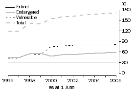
The natural landscape, Biodiversity – Threatened bird and mammal species
 For technical information see Endnote 11.
Source: Data compiled from schedules to the Commonwealth Acts: the Endangered Species Protection Act 1992 and
the Environment Protection and Biodiversity Conservation Act 1999.
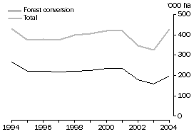
The natural landscape, Biodiversity – Annual area of land cleared
 Estimates for 2003 and 2004 are preliminary.
For further technical information see Endnote 12.
Note: This graph has been revised with new data from the Australian Greenhouse Emissions Information System. Data for 2005 has not been included as the area of land cleared was not re-estimated for the 2005 National Greenhouse Gas Inventory.
Source: Australian Greenhouse Office 2007, Australian Greenhouse Emissions Information System.
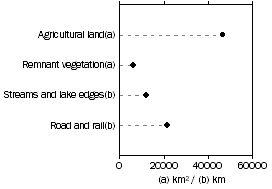
The natural landscape, Land – Assets affected by, or at risk from, salinity — 2000
 For technical information see Endnote 13.
Source: Australian Dryland Salinity Assessment 2000, National Land and Water Resources Audit 2001.
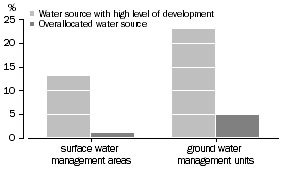
The natural landscape, Inland waters – Water resources level of development — 2004-05
 For technical information see Endnote 14.
Source: National Water Commission, Australian Water Resources 2005.
The air and atmosphere, days fine particle health standards were exceeded
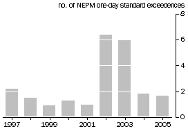 For technical information see Endnotes 15, Endnote 16.
Source: State environmental protection agencies, 2006;
Regional Population Growth, Australia (cat. no. 3218.0).
The air and atmosphere, Australia's net greenhouse gas emissions
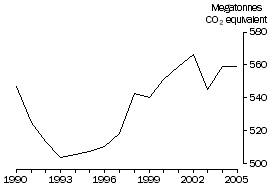 Estimates for 2003, 2004 and 2005 are preliminary.
For further technical information see Endnote 17.
Note: This graph has been updated with data from the 2005 National Greenhouse Gas Inventory.
Source: Australian Greenhouse Office 2007, National Greenhouse Gas Inventory 2005.
THE NATURAL LANDSCAPE
Biodiversity
No single indicator can hope to encapsulate biodiversity, and so we focus on two aspects: the numbers of extinct and threatened Australian birds and mammals; and the clearing of native vegetation.
Although the numbers of threatened birds and mammals are only a small part of the overall biological diversity, a decline in these groups of species threatens ecological processes and can point to a wider decline in biodiversity. The list should not be construed as a census of threatened species as species can be added to or removed from the list as their status changes or due to improved knowledge (see Endnote 11). However, the list is as accurate an account of the status of these species as can be currently compiled.
Between 1996 and 2006 the number of bird and mammal species assessed as extinct, endangered or vulnerable rose by 44% from 119 to 171 (of which 68 were birds and 103 were mammals). At 1 June 2006, just under half (47%) of these species were vulnerable, around one-third (35%) were more seriously threatened (endangered) and the remainder (18%) were presumed extinct over the 10 year period. There were increases in the numbers of both endangered and vulnerable species, but the rise in species assessed as vulnerable was much higher (88%) than those assessed as endangered (31%).
Land clearing destroys plants and local ecosystems and removes the food and habitat on which other native species rely. Clearing allows weeds and invasive animals to spread, affects greenhouse gas emissions and can lead to soil degradation, such as erosion and salinity, which in turn can affect water quality. The land clearing estimates include information about forest conversion (land cleared for the first time) and total land cleared which includes forest conversion plus reclearing, both of which have environmental impacts (see Endnote 12).
The estimated 424,600 ha of Australian land cleared in 2004 is 1% less than the 430,900 ha cleared in 1994. Of the land cleared in 2004, just under half (195,900 ha) was ‘forest conversion' (forest cleared for the first time). This was 26% less than the area converted in 1994 (266,000 ha) (see Endnote 12). (Note: This paragraph has been revised with new data from the Australian Greenhouse Emissions Information System. Data for 2005 has not been included as the area of land cleared was not re-estimated for the 2005 National Greenhouse Gas Inventory.)
Land
Australia's soils are old and shallow, and are susceptible to degradation by agricultural activities. Dryland salinity for example, occurs when trees or other deep-rooted vegetation are replaced with vegetation that uses less water. This causes the water table to rise bringing natural salts to the surface, and in sufficient quantity, these salts are toxic to most plants. Dryland salinity threatens biodiversity, through loss of habitat on land and in water, and also impacts on water resources, pipelines, houses and roads. Areas near water are often worst affected because they occupy the lowest parts of the landscape where saline groundwater first reaches the surface.
In 2000, about 46,500 km˛ (4.65 million hectares) of agricultural land were already affected with a high salinity hazard or in an area at high risk from shallow watertables. Salinity can also damage structures, as well as flora and fauna. The salt contained in rising groundwater levels can damage bitumen and concrete and so affect roads, footpaths, housing, pipelines and other assets. In 2000, about 11,800 km of streams and lake edges, as well as 1,600 km of rail and 19,900 km of roads were affected or at risk.
The salinity data presented above for this headline indicator have not been updated since the first release of MAP in 2002, as there is no more recently available data. However, the effects of dryland salinity are still considered an important measure of environmental progress.
Inland waters
Water is fundamental to the survival of people and other organisms. Apart from drinking water, much of our economy (agriculture in particular) relies on water. The condition of freshwater ecosystems has a critical impact on the wider environment.
In the year ending June 2005, about 1% of Australia’s 340 surface water management areas were overallocated and a further 13% were developed to a high level. This proportion was greater for the 367 groundwater management units, where 5% were overallocated, and a further 23% had a high level of development (see Endnote 14). This data is not directly comparable with the data previously presented in MAP (e.g. National Land and Water Resources Audit 2001, Australian Water Resources Assessment 2000) for a number of reasons including management changes, and changes to the definitions of sustainable yield and level of development.
THE AIR AND ATMOSPHERE
Urban air quality
Poor air quality has a range of negative impacts: it can cause health problems, damage infrastructure, reduce crop yields and harm flora and fauna. Air pollution occurs both naturally and as a result of human activities. Australians consistently rank air pollution as a major environmental concern. The headline indicator considers the concentration of fine particles in the atmosphere, a measure of the form of air pollution about which many health experts in Australia are most concerned. The measure summarises data from continuous air monitoring stations in Sydney, Melbourne, Adelaide, Perth and Brisbane (see Endnote 15).
The common air pollutants are found at higher levels in urban and industrial areas than in rural Australia. It is important to note that daily changes in air quality depend on ambient conditions, like wind direction and the monitoring station’s proximity to pollution sources. Further, high concentrations of fine particles from irregular events, such as bushfires, can obscure the longer trend in levels produced by regular sources, like car emissions.
Overall, air quality in Australia is relatively good. Fine particle health standards (see Endnote 16) were exceeded in the selected urban areas on average between one and two days each year between 1997 and 2005 with the exception of 2002 and 2003. The number of days where standards were exceeded was higher in 2002 and 2003, mainly due to severe bushfires and dust storms around the Sydney and Melbourne areas, causing the National Environment Protection Measure (NEPM) to be exceeded on 13 days in Sydney in 2002 and 10 days in Melbourne in 2003. The NEPM was also exceeded on eight days in Brisbane in 2002.
Net greenhouse gas emissions
Global warming is widely perceived as one of the most significant international environmental concerns. Australia's contribution to the changing global warming levels is an important aspect of progress.
The main gases in the atmosphere, nitrogen and oxygen, are almost completely transparent to the sun's rays. But water vapour, carbon dioxide and other gases form a blanket around the Earth, trapping heat – a process called the greenhouse effect. Human activity is increasing atmospheric concentrations of existing greenhouse gases (such as carbon dioxide and methane) and adding new gases such as chlorofluorocarbons (CFCs). Net emissions are estimated using information about total emissions, less any credits from forest sinks (the credits are estimates of how much carbon dioxide has been absorbed by new and expanding forests established in Australia since 1990).
For 2005, Australia's net greenhouse gas emissions were estimated to be 559.1 megatonnes of carbon dioxide-equivalent (CO2-e) (see Endnote 17). Australia's net emissions in 2005 were the same as 2004 emissions, 2.6% higher than in 2003, and 2.2% above 1990 levels. (The year 1990 is the base period for the reporting of emissions under the Kyoto protocol.) Emissions tended to rise gradually over the period from 1993. The sharpest rise was between 1997 and 1998 when emissions from land use change rose rather than fell as they had done during most of the decade. (Note: This paragraph has been updated with data from the 2005 National Greenhouse Gas Inventory.)
OCEANS AND ESTUARIES
Australia’s coastal and marine regions support a large range of species, many of them found only in Australian waters. These regions are also important to Australian society and the economy. Although this dimension has no headline indicator, it does have important aspects which different organisations have attempted to measure.
One such aspect is the sustainability of fish stocks. Australia's major fisheries target prized species such as lobsters, prawns, abalone and tuna, which despite modest production tonnage in world terms, are subject to high fishing pressure. Overfishing occurs when the fishing pressure is too heavy to allow the fish population to replenish itself, or when too many small fish are taken, and therefore too few grow to a size that provides the largest yield from that fishery. Overfished species are those for which the current stock is below a reference point set by scientists and managers.
In 2005, for fish stocks managed by the Australian Government, 24 of the 83 principal species that are classified were overfished or subject to overfishing. This compares with 3 species in 1996. In contrast, some progress has been made in reducing overfishing for some species. In the Northern Prawn Fishery, stocks of Grooved and Brown tiger prawns have recovered in recent years to the extent that these species are no longer classified as overfished (see Endnote 18).
Measuring the condition of estuaries not only reports on the state of our oceans; it sheds light on how land use around the water that flows into the estuary is affecting the sea. The Estuarine Condition Index, developed by the National Land and Water Resources Audit (NLWRA), provides a snap shot of estuary health. While there is no recent data for this measure, it has been reported in MAP: Summary Indicators 2006 (cat. no. 1383.0.55.001).
 Print Page
 Print All