Australian Statistical Geography Standard (ASGS) Edition 3
A classification of Australia into a hierarchy of statistical areas for the publication and analysis of official statistics and other data
Overview
The Australian Statistical Geography Standard (ASGS) is a classification of Australia into a hierarchy of statistical areas. It is a social geography, developed to reflect the location of people and communities. It is used for the publication and analysis of official statistics and other data. The ASGS is updated every 5 years to account for growth and change in Australia’s population, economy and infrastructure.
For the 2021 release, the ASGS will be re-named to the Australian Statistical Geography Standard (ASGS) Edition 3. Until this point, the ASGS has been named according to the Census of Population and Housing year it referred to. This has led to confusion as the ASGS has historically been published across several years. For example, the Urban Centres and Localities publication for ASGS Edition 2 (2016) was published in 2017.
ASGS Edition 3 will be used for the 2021 Census of Population and Housing, and will be progressively introduced into other ABS data collections from 2022. ASGS Edition 3 is an update of ASGS Edition 2 (2016).
Release schedule
For the first time, this edition combines the entire ASGS framework into one publication which will be updated progressively. The expected release schedule can be found in the following table.
| Section of the ASGS | Expected release |
|---|---|
| Main Structure and Greater Capital City Statistical Areas | July 2021 |
| Indigenous Structure | October 2021 |
| Non ABS Structures | October 2021 |
| Significant Urban Areas, Urban Centres and Localities, Section of State | October 2022 |
| Remoteness Structure | March 2023 |
ASGS Edition 3 Structures
The ASGS is split into two parts, the ABS and Non ABS Structures.
The ABS Structures are geographies that the ABS designs specifically for the release and analysis of statistics. This means that the statistical areas are designed to meet the requirements of statistical collections as well as geographic concepts relevant to those statistics. This helps to ensure the confidentiality, accuracy and relevance of ABS data.
The ABS Structures include several different geographies that approximate urban areas, and these may differ from official or commonly accepted definitions. A brief description of these geographies can be found in this section, and further detail is available in relevant sections of this publication.
The Non ABS Structures generally represent administrative regions which are not defined or maintained by the ABS, but for which the ABS is committed to directly providing a range of statistics. All Non ABS Structures are approximated using ASGS regions. Because of this, they are only cartographic representations of legally (or otherwise) designated boundaries, for example ASGS State and Territory boundaries and Local Government Areas, and should not be used for legal purposes.
Before using an ASGS geography, the purpose, design criteria, and update frequency should be carefully considered. ABS Maps can be used to compare geographies visually.
ABS Structures
The ABS Structures consist of six interrelated hierarchies of regions:
Main Structure
The Main Structure is developed by the ABS and is used to release and analyse a broad range of social, demographic and economic statistics. It is a nested hierarchy of geographies, and each level directly aggregates to the next level.
Mesh Blocks (MBs) are the smallest geographic areas defined by the ABS and form the building blocks for the larger regions of the ASGS. Most Mesh Blocks contain 30 to 60 dwellings.
Statistical Areas Level 1 (SA1s) are designed to maximise the geographic detail available for Census of Population and Housing data while maintaining confidentiality. Most SA1s have a population of between 200 to 800 people.
Statistical Areas Level 2 (SA2s) are medium-sized general purpose areas built to represent communities that interact together socially and economically. Most SA2s have a population range of 3,000 to 25,000 people.
Statistical Areas Level 3 (SA3s) are designed for the output of regional data and most have populations between 30,000 and 130,000 people.
Statistical Areas Level 4 (SA4s) are designed for the output of a variety of regional data, and represent labour markets and the functional area of Australian capital cities. Most SA4s have a population of over 100,000 people.
States and Territories (S/T) are a cartographic representation of legally designated state and territory boundaries.
Australia (AUS) is the largest region in the ASGS and represents the geographic extent of Australia.
Indigenous Structure
The Indigenous Structure enables the publication and analysis of statistics for the Aboriginal and Torres Strait Islander population of Australia.
Indigenous Locations (ILOCs) represent small Aboriginal and Torres Strait Islander communities (urban and rural) with a minimum population of about 90 people.
Indigenous Areas (IAREs) are medium sized geographical areas designed to facilitate the release of more detailed statistics for Aboriginal and Torres Strait Islander people.
Indigenous Regions (IREGs) are large geographical areas based on historical boundaries. The larger population of Indigenous Regions enables highly detailed analysis.
Urban Centres and Localities, and Section of State Structure
Urban Centres and Localities and Section of State represent areas of concentrated urban development.
Urban Centres and Localities (UCLs) are aggregations of SA1s which meet population density criteria or contain other urban infrastructure. As populations and urban areas change, these UCLs are also designed to change, and areas can come into or out of the classification. This ensures meaningful data is available for urban areas and there are accurate comparisons over time.
Section of State (SOS) groups the UCLs into classes of urban areas based on population size. SOS does not explicitly define rural Australia, however any population not contained in a UCL is considered to be rural.
Section of State Range (SOSR) provides a more detailed classification than SOS. This enables statistical comparison of differently sized urban centres and rural areas.
Remoteness Structure
Remoteness Areas divide Australia and the states and territories into 5 classes of remoteness on the basis of their relative access to services. Remoteness Areas are based on the Accessibility/Remoteness Index of Australia Plus (ARIA+), produced by the Hugo Centre for Population and Migration Studies.
Greater Capital City Statistical Area Structure
Greater Capital City Statistical Areas (GCCSAs) represent the functional area of each of the eight state and territory capital cities.
Significant Urban Area Structure
Significant Urban Areas (SUAs) represent individual Urban Centres or clusters of related Urban Centres with a core urban population of over 10,000 people.
Non ABS Structures
The Non ABS Structures consist of eight geographies:
- Local Government Areas (LGA) are an ABS Mesh Block representation of gazetted Local Government boundaries as defined by each state and territory.
- State Electoral Divisions (SED) are an ABS Mesh Block approximation of state electoral districts.
- Commonwealth Electoral Divisions (CED) are an ABS Mesh Block approximation of the Australian Electoral Commission (AEC) federal electoral division boundaries.
- Postal Areas (POA) are an ABS Mesh Block approximation of a general definition of postcodes.
- Tourism Regions (TR) are an ABS SA2 approximation of tourism regions as provided by Tourism Research Australia.
- Australian Drainage Divisions (ADD) are an ABS Mesh Block approximation of drainage divisions as provided through Australian Hydrological Geospatial Fabric.
- Suburbs and Localities (formerly State Suburbs) (SAL) are an ABS Mesh Block approximation of gazetted localities.
- Destination Zones (DZN) are co-designed with state and territory transport authorities for the analysis of Place of Work Census of Population and Housing data, commuting patterns and the development of transport policy.
Figure 1 depicts the various ABS and Non ABS Structures, their component regions and how they interrelate.
ASGS diagram
Figure 1
Image
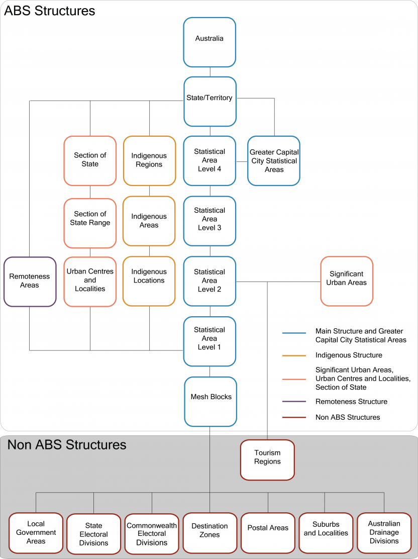
Description
Further detail on how both the ABS Structures and Non ABS Structures are designed is available in the different sections of this publication.
Key changes
For ASGS Edition 3, Mesh Blocks, SA1s and SA2s have been updated to reflect population growth and changes to infrastructure. These changes allow users to access meaningful statistics on communities of interest. Detailed information on Main Structure changes is recorded in the Changes from the previous edition of the ASGS section of this publication.
Other significant changes to the ASGS since 2016 are:
- short codes for SA1s and SA2s will no longer be provided
- digital boundaries are now published using both the Geocentric Datum of Australia 94 (GDA94) and Geocentric Datum of Australia 2020 (GDA2020)
- Main Structure and GCCSA geographies now have a ‘Change Flag’ attribute denoting whether an area is new in Edition 3, or has a code or name change
- Destination Zones (DZNs) are now officially included in Non ABS Structures
- Natural Resource Management Regions (NRMRs) are no longer published as part of the ASGS
- Commonwealth Electoral Divisions (CEDs) and State Electoral Divisions (SEDs) are now built up from Mesh Blocks rather than SA1s
- a Uniform Resource Identifier (URI) attribute has been added to all ASGS boundaries, which can be used in data integration
Non ABS Structures update schedule
For ASGS Edition 3, the Non ABS Structures schedule will change slightly from previous editions. State Electoral Divisions and Commonwealth Electoral Divisions will be updated in 2021, and then only in years where there have been electoral redistributions. The ABS will continue to support users accessing data on redistributed boundaries outside of this release schedule through the provision of allocation and correspondence files.
| Non ABS geography | Update schedule |
|---|---|
| Local Government Areas | 2021 then annually |
| State Electoral Divisions | 2021 then annually (only when redistributions have occurred) |
| Commonwealth Electoral Divisions | 2021 then annually (only when redistributions have occurred) |
| Postal Areas | 2021 - Every five years |
| Tourism Regions | 2021 - Every five years |
| Australian Drainage Divisions | 2021 - Every five years |
| Suburbs and Localities* | 2021 - Every five years |
| Destination Zones | 2021 - Every five years |
*Suburbs and Localities are called State Suburbs in previous editions of the ASGS