AUSTRALIAN CAPITAL REGION DEMOGRAPHY
Map of the ACR
Population
Introduction
The Australian Capital Region (ACR) comprises the ACT and the 17 surrounding Local Government Areas. State, territory, and local representatives from these areas meet regularly to discuss common issues through the Regional Leaders Forum (RLF).
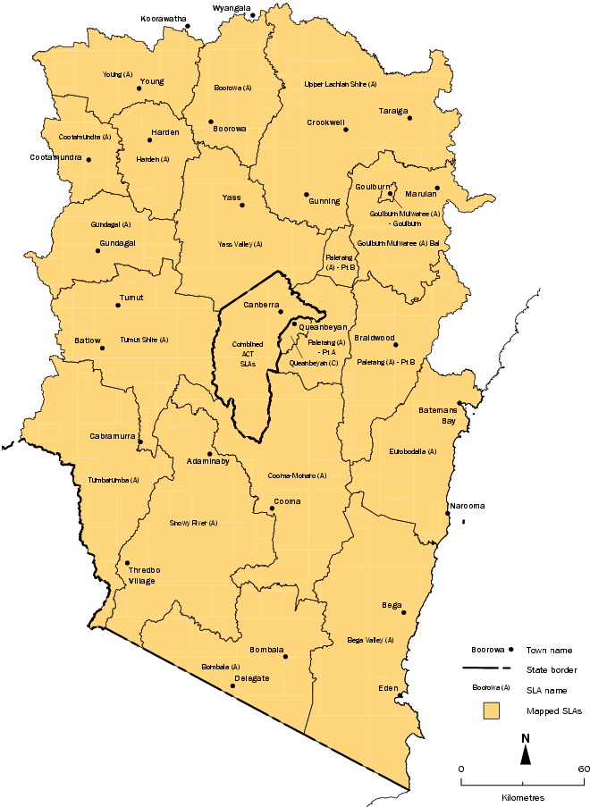
Map of the Region
Statistical Local Areas
Population
ESTIMATED RESIDENT POPULATION(a), Australian Capital Region - By Statistical Local Area |
|
 | | 2009 |
| | psns |
|
| Australian Capital Territory | |
| Acton | p1 963 |
| Ainslie | p5 320 |
| Braddon | p4 134 |
| Campbell | p3 332 |
| City | p1 244 |
| Dickson | p2 157 |
| Downer | p3 579 |
| Duntroon | p1 647 |
| Hackett | p3 008 |
| Kowen | p48 |
| Lyneham | p4 871 |
| Majura | p124 |
| O'Connor | p5 445 |
| Reid | p1 639 |
| Russell | p - |
| Turner | p3 545 |
| Watson | p4 777 |
| Aranda | p2 511 |
| Belconnen Town Centre | p3 517 |
| Belconnen - SSD Bal | p42 |
| Bruce | p4 919 |
| Charnwood | p3 193 |
| Cook | p2 998 |
| Dunlop | p6 859 |
| Evatt | p5 578 |
| Florey | p5 363 |
| Flynn | p3 696 |
| Fraser | p2 223 |
| Giralang | p3 425 |
| Hawker | p2 991 |
| Higgins | p3 197 |
| Holt | p4 994 |
| Kaleen | p7 801 |
| Latham | p3 822 |
| McKellar | p2 997 |
| Macgregor | p3 867 |
| Macquarie | p2 615 |
| Melba | p3 439 |
| Page | p2 837 |
| Scullin | p2 909 |
| Spence | p2 764 |
| Weetangera | p2 687 |
| Chifley | p2 444 |
| Curtin | p5 352 |
| Farrer | p3 539 |
| Garran | p3 317 |
| Hughes | p2 991 |
| Isaacs | p2 536 |
| Lyons | p2 608 |
| Mawson | p3 056 |
| O'Malley | p909 |
| Pearce | p2 642 |
| Phillip | p2 070 |
| Torrens | p2 314 |
| Chapman | p2 804 |
| Duffy | p3 212 |
| Fisher | p3 208 |
| Holder | p2 717 |
| Rivett | p3 231 |
| Stirling | p2 095 |
| Stromlo | p73 |
| Waramanga | p2 619 |
| Weston | p3 296 |
| Weston Creek-Stromlo - SSD Bal | p21 |
| Banks | p5 369 |
| Bonython | p3 728 |
| Calwell | p6 094 |
| Chisholm | p5 462 |
| Conder | p5 448 |
| Fadden | p3 232 |
| Gilmore | p2 930 |
| Gordon | p8 037 |
| Gowrie | p3 247 |
| Greenway | p1 333 |
| Isabella Plains | p4 371 |
| Kambah | p15 883 |
| Macarthur | p1 553 |
| Monash | p5 565 |
| Oxley | p1 909 |
| Richardson | p3 331 |
| Theodore | p4 122 |
| Tuggeranong - SSD Bal | p65 |
| Wanniassa | p8 139 |
| Barton | p1 138 |
| Deakin | p2 780 |
| Forrest | p1 428 |
| Fyshwick | p57 |
| Griffith | p4 342 |
| Harman | p93 |
| Hume | p4 |
| Jerrabomberra | p13 |
| Kingston | p2 902 |
| Narrabundah | p5 898 |
| Oaks Estate | p252 |
| Parkes | p6 |
| Pialligo | p119 |
| Red Hill | p3 371 |
| Symonston | p511 |
| Yarralumla | p3 097 |
| Amaroo | p6 984 |
| Bonner | p - |
| Casey | p - |
| Crace | p - |
| Forde | p432 |
| Franklin | p862 |
| Gungahlin | p4 393 |
| Gungahlin-Hall - SSD Bal | p21 |
| Hall | p371 |
| Harrison | p4 201 |
| Mitchell | p5 |
| Ngunnawal | p9 895 |
| Nicholls | p7 648 |
| Palmerston | p6 096 |
| Remainder of ACT | p321 |
| Australian Capital Region - remainder | |
| Palerang (A) - Pt A | p10 589 |
| Queanbeyan (C) | p40 661 |
| Boorowa (A) | p2 452 |
| Goulburn Mulwaree (A) - Goulburn | p21 745 |
| Goulburn Mulwaree (A) Bal | p6 604 |
| Harden (A) | p3 624 |
| Palerang (A) - Pt B | p3 734 |
| Upper Lachlan Shire (A) | p7 512 |
| Yass Valley (A) | p14 796 |
| Young (A) | p12 861 |
| Bega Valley (A) | p33 481 |
| Eurobodalla (A) | p37 442 |
| Bombala (A) | p2 615 |
| Cooma-Monaro (A) | p10 416 |
| Snowy River (A) | p8 061 |
| Cootamundra (A) | p7 703 |
| Gundagai (A) | p3 870 |
| Tumut Shire (A) | p11 396 |
| Tumbarumba (A) | p3 735 |
|
| - nil or rounded to zero (including null cells) |
| p preliminary figure or series subject to revision |
| (a) The dataset contains estimates of the resident population of Statistical Local Areas (SLAs) as at 30 June 2009. Estimates for 2009 are preliminary, based on the results of the 2006 Census of Population and Housing. SLAs are based on the Australian Standard Geographical Classification 2009 Edition for all years. Further information about the estimates should be obtained from the Explanatory Notes of Regional Population Growth, Australia (cat. no. 3218.0). |
 Print Page