INDEX OF RELATIVE SOCIO-ECONOMIC DISADVANTAGE
This section analyses the socio-economic status of the Murray-Darling Basin using the Index of Relative Socio-economic Disadvantage (IRSD) constructed for Statistical Local Areas (SLAs, see map E.2 of the Explanatory Notes). Areas with the highest relative disadvantage typically have higher proportions of low income families, unemployed people, people without educational qualifications, households renting from public housing, and people in unskilled or semi-skilled occupations. Conversely, the least disadvantaged areas tend to have a low proportion of people with these characteristics.
In 2006, more than half (55%) of the SLAs in the Basin had an index value lower than the national average. About 68% of the population in the MDB resided in these areas.
Table 2.17 below shows the IRSD in SLAs across quintiles in the Basin compared to the national distribution. SLAs in the highest quintile are considered less disadvantaged while SLAs in the lower quintiles are more disadvantaged.
Australia-wide, there are equal numbers of SLAs in each quintile. However, the data shows that the Basin has many more SLAs in the second (26% of SLAs) and highest quintile (25% of SLAs). Less than 15% of SLAs in the Basin were in the lowest quintile, those considered to be the most disadvantaged.
2.17 Index of Relative Socio-Economic Disadvantage, by Statistical Local Area - 2006 |
|  |
| Murray-Darling Basin | Australia | |
| Number of SLAs | Proportion of total SLAs | Proportion of total SLAs | |
| Income quintile | no. | % | % | |
| |
| Highest quintile | 75 | 25.3 | 20.0 | |
| 4th quintile | 52 | 17.6 | 20.0 | |
| 3rd quintile | 48 | 16.2 | 20.0 | |
| 2nd quintile | 78 | 26.4 | 20.0 | |
| Lowest quintile | 43 | 14.5 | 20.0 | |
| Total SLAs(a) | 296 | 100.0 | 100.0 | |
| |
| (a) Excludes SLAs without information. |
| Source: ABS data available on request, Socio-Economic Indexes for Areas (SEIFA), 2006 |
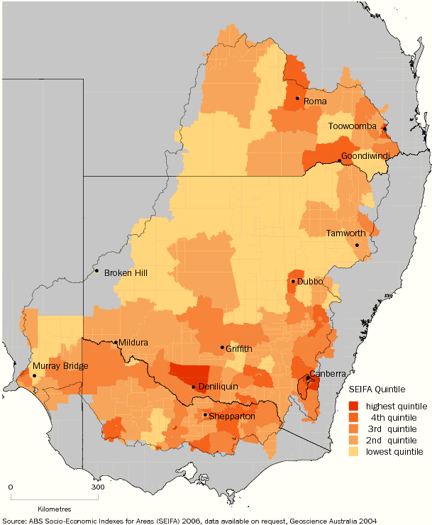
Map 2.18 shows the distribution of IRSD for SLAs in the Basin. Lighter shading indicates higher levels of disadvantage while darker shading indicates lower levels of disadvantage.
The more disadvantaged areas (lowest quintiles) tend to cluster around the central, south-western and northern parts of the Basin. The less disadvantaged areas (highest quintiles) tend to cluster around some of the major urban centres in the southern and south-eastern parts of the Basin, as well as in the northern and north-eastern parts.
2.18 Index of Relative Socio-Economic Disadvantage, Statistical Local Area
- Murray-Darling Basin - 2006
 Print Page
 Print All