OVERVIEW
Agriculture is an important industry in the MDB, using 84% of the Basin's land in 2005-06 (see table 1.4 in Chapter 1). Moreover, 88.8 million hectares (ha) or 20% of Australia's agricultural land use occurred within the MDB (table 4.1). Approximately $15 billion of Australia's total value of agricultural commodities were produced in the MDB. This represented 39% of the Australian value of agricultural commodity production. Of the Basin states, New South Wales made the most significant agricultural contribution, with 51.2 million ha or 58% of the Basin's agricultural land, and almost half (49%) of the farms in 2005-06.
4.1 Number of farms and agricultural area—At 30 June 2006 |
|  |
| | Farms | Agricultural area | |
| | Number | Proportion of Australian farms | Area | Proportion of Australian agricultural area | |
| | no. | % | '000 ha | % | |
| |
| Murray-Darling Basin | | | | | |
| New South Wales | 29 803 | 19 | 51 214 | 12 | |
| Victoria | 18 496 | 12 | 7 593 | 2 | |
| Queensland | 7 881 | 5 | 23 421 | 5 | |
| South Australia | 4 753 | 3 | 6 555 | 2 | |
| Australian Capital Territory | 99 | - | 45 | - | |
| Total(a) | 61 033 | 39 | 88 828 | 20 | |
| Balance of Australia | | | | | |
| New South Wales | 19 034 | 12 | 10 906 | 3 | |
| Victoria | 18 650 | 12 | 4 721 | 1 | |
| Queensland | 24 331 | 16 | 122 098 | 28 | |
| South Australia | 11 702 | 8 | 48 854 | 11 | |
| Western Australia | 14 526 | 9 | 98 653 | 23 | |
| Tasmania | 4 745 | 3 | 1 739 | - | |
| Northern Territory | 659 | - | 59 127 | 14 | |
| Total(a) | 93 648 | 61 | 346 097 | 80 | |
| Australia | 154 681 | 100 | 434 925 | 100 | |
| |
| - nil or rounded to zero (including null cells) |
| (a) Components may not add to total due to rounding. |
| Source: Water Use on Australian Farms, 2005–06, cat. no. 4618.0 |
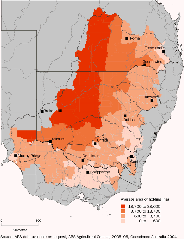
Within the MDB, average farm size is smaller in Victoria than in the other states. Map 4.2 shows the average size of agricultural holdings across Statistical Local Areas (SLAs) sourced from the Agricultural Census 2005-06. It illustrates that the largest farms are located in the north-west of the MDB and that farms generally have smaller areas in the south-eastern parts of the Basin.
4.2 AVERAGE AREA OF AGRICULTURAL HOLDING, by Statistical Local Area—Murray-Darling Basin—2006
 Print Page
 Print All