This document was added or updated on 29/06/2016.
FEATURE ARTICLE: SUBURBAN LANDUSE CHANGE ADELAIDE
INTRODUCTION
As with most Australian cities, Adelaide has a vision to promote a significant shift in the pattern of suburban growth towards infill development and urban renewal in activity centres located along transit corridors (Table 1).
For Adelaide, The 30-Year Plan for Greater Adelaide identified planning for net growth of 258,000 dwellings over thirty years. The focus of future growth will be away from urban sprawl to protect food growing areas and natural landscapes (Department of Planning and Local Government 2010). The 30 Year Plan proposes a shift towards smaller medium-high density dwellings, with a move away from larger detached dwellings, as projected in Table 2.
Table 1 Infill targets for selected Australian cities/regions
|
| City/region | Timeframe | Target dwellings | Percentage from infill |
 | | No. | % |
|
| Sydney | 2005-31 | 640 000 | 60 to 70 |
| Melbourne | 2009-30 | 600 000 | 53 |
| South-East Queensland | 2009-31 | 754 000 | 50 |
| Perth | 2009-31 | 328 000 | 47 |
| Adelaide | 2010-40 | 258 000 | moving from 50 to 70 |
|
Source: Greening the Greyfields: Unlocking the Redevelopment Potential of the Middle Suburbs in Australian Cities, Newton, Newman, Glackin and Trubka 2012.
Table 2 Projected number and type of dwellings, 30 Year Plan for Greater Adelaide
|
| Business As Usual | 30 Year Plan |
| No. Dwellings | % | No. Dwellings | % |
|
| High Density | 10 000 | 4 | 36 000 | 14 |
| Medium Density | 52 000 | 20 | 93 000 | 36 |
| Detached | 196 000 | 76 | 129 000 | 50 |
|
Notes: High density = average floor area 147sqm; Medium density = average floor area 147sqm; Detached = average floor area 197sqm. Medium and High-density housing may have same flooring size. Density a reflection of semi-detached vs multi-story. The 30 Year Plan is currently under review and will distribute revised population and dwelling targets when complete.
Source: The 30-Year Plan for Greater Adelaide, South Australian Department of Planning and Local Government 2010.
This case study uses South Australian Valuer General Data to look at house and block size for the Adelaide Urban Centre and Locality (UCL) over the past few decades (up to 2014). Only records classified as "Private" and "Single Unit Houses" within the Adelaide UCL were included in the analysis (approximately 80% of Valuer General Data). The house size used is the reported "Equivalent Main Area" of the house- that is the total area under the main roof, excluding verandahs, carports, garages etc.
BACKGROUND
According to the ABS
Land Account: South Australia, Experimental Estimates, 2006-2011 (cat. no. 4609.4.55.001), the area of 'Residential' land in the Adelaide and Mount Lofty Ranges NRM increased from 90,500 to 94,800 hectares between 2006 and 2011 (4.8%). Residential land in the Adelaide and Mount Lofty NRM accounted for 67% ($106 billion) of all rateable value in 2006 and 68% ($164 billion) in 2011. Livestock grazing (177,300 ha), Mixed farming and grazing (158,800 ha), and Residential (94,800 ha) combined accounted for two-thirds of land use for the Adelaide and Mount Lofty Ranges NRM in 2011. Residential showed the largest land use increase between 2006 and 2011 (4,300 ha), while livestock grazing showed the largest decrease (5,400 ha).
Over the same period, private dwellings in Greater Adelaide increased by 6.6%, with just over three-quarters of dwellings being separate (detached) houses. Over this period, the number of separate house dwelling types increased by 6% (an addition of nearly 23,000 separate house dwellings), compared with an increase of 9% for medium/high density dwelling types (additional 10,500 medium/high density dwellings). The proportion of high and medium density dwelling types remained virtually unchanged over this period (Table 3).
Table 3 Dwelling type, Greater Adelaide and Australia, 2006 - 2011
|
| Dwelling Type | 2006 | 2011 | 2006 to 2011 |
| No. | % | No. | % | No. Change |
|
| Separate house | 381 218 | 76.2 | 404 212 | 75.8 | 22 994 |
| Medium density | 107 725 | 21.5 | 116 337 | 21.8 | 8 612 |
| High density | 9 024 | 1.8 | 10 908 | 2.0 | 1 884 |
| Caravans, cabin, houseboat | 1 358 | 0.3 | 1 196 | 0.2 | -162 |
| Other | 778 | 0.2 | 616 | 0.1 | -162 |
| Not stated | 294 | 0.1 | 240 | 0.0 | -54 |
| Total private dwellings | 500 397 | 100.0 | 533 509 | 100.0 | 33 112 |
|
Source: Australian Bureau of Statistics, Census of Population and Housing 2006 and 2011.
At June 2014, the estimated resident population of South Australia (SA) was 1.7 million people. Over 77% of the state's population resided in Greater Adelaide in 2014. Within Greater Adelaide, the SA3s of Adelaide City and Playford had the fastest growth over this five-year period, both increasing by 14%. This was followed by Port Adelaide - East (11%), Gawler - Two Wells (7.0%) and Port Adelaide - West (6.4%). Tea Tree Gully was the only SA3 in Greater Adelaide to decline in population, down by 0.2%.
With Greater Adelaide's population forecast to continue to grow, initiatives to accommodate this growing population include facilitating higher density and mixed-use development in Adelaide's city centre and inner metropolitan area, with a view to Adelaide's city centre and inner metropolitan area accommodating a far greater proportion of the population (
Building a Stronger South Australia: The integrated land use and transport plan, Government of South Australia 2015).
ADELAIDE SUBURBAN LANDUSE CHANGE, 1980 - 2014
Between 1980 and 2014, the number of private single unit houses in the Adelaide UCL has increased by 69%. Over this period, average block size has decreased by 8%, while average house size has increased by 11%. Overall, mean house to block size ratio has increased from 20 to 25 (28%) (Table 4).
Table 4 House to block size change, All dwellings, Adelaide UCL, 1980 - 2014
|
| House to Block Size Ratio | Frequency | Average block size | Change from 1980 | Average house size | Change from 1980 | Mean Adjusted Area Ratio | Change from 1980 |
| No. | square meters | % | square meters | % | | % |
|
| prior to 1980 | 200 928 | 779 | 0 | 143 | 0 | 20 | 0 |
| prior to 1990 | 237 544 | 779 | 0 | 147 | 2 | 20 | 3 |
| prior to 2000 | 278 473 | 759 | -3 | 151 | 6 | 22 | 11 |
| prior to 2010 | 321 784 | 732 | -6 | 157 | 10 | 24 | 23 |
| prior to 2014 | 340 099 | 718 | -8 | 159 | 11 | 25 | 28 |
|
Note: For multistory houses where the ratio exceeded 100 this was adjusted to a ratio of 100.
The maps below (Figures 1-4) show the change in mean house to block size ratio between 1990 and 2014, for SA1s in the Adelaide UCL. Inner city, eastern and coastal areas have consistently had higher mean house to block size ratios, however in recent years this has expanded to areas on the outskirts and pockets of northern areas. Overall, 83% of SA1s have increased in mean house to block size ratio over time. The rise in mean house to block size ratio can be attributed to both increased house size in established suburbs as well as shrinking lot sizes for detached dwelling developments on the urban fringe (also see Table 4 above for increase in housing types between 2006 and 2011).
Figure 1 - Mean house to block size ratio, by SA1, Adelaide UCL, 1990
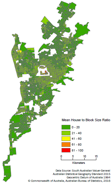
Figure 2 - Mean house to block size ratio, by SA1, Adelaide UCL, 2000
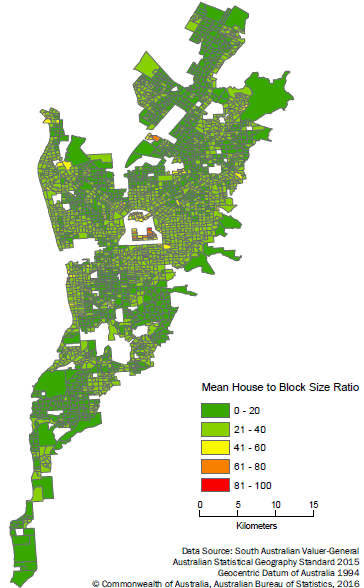
Figure 3 - Mean house to block size ratio, by SA1, Adelaide UCL, 2010
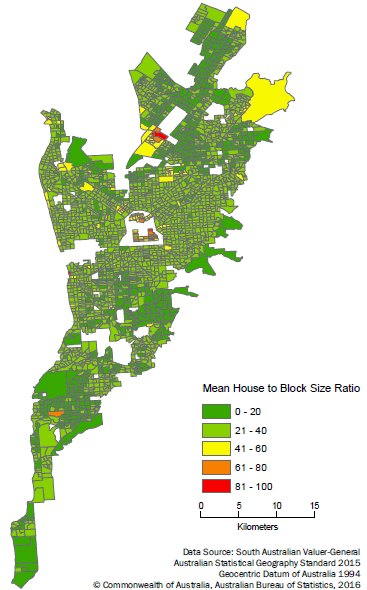
Figure 4 - Mean house to block size ratio, by SA1, Adelaide UCL, 2014
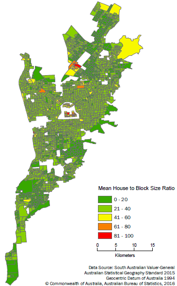
Table 5 shows the largest increase in mean house to block size ratio occurring between the end of the 1990s and the end of the first decade of the 2000s. The mean house to block size ratio for new dwellings built between 2010 and 2014 was nearly double the mean house to block size ratio of dwellings built in the decade to 1990. This increase in mean house to block size ratio over the past couple of decades has not been restricted to the city centre and inner metropolitan suburbs (see Figures 1-4).
Table 5 House to block size change, New dwellings, Adelaide UCL, 1980 - 2014
|
| House to Block Size ratio | Frequency | Average Block Size | Average House Size | Mean Adjusted Area Ratio |
| No. | square meters | square meters | |
|
| prior to 1980 | 200 928 | 779 | 143 | 20 |
| 1980 to 1989 | 36 616 | 780 | 165 | 23 |
| 1990 to 1999 | 40 929 | 644 | 177 | 31 |
| 2000 to 2009 | 43 311 | 560 | 196 | 40 |
| 2010 to 2014 | 20 389 | 466 | 182 | 44 |
|
Note: For multistory houses where the ratio exceeded 100 this was adjusted to a ratio of 100.
DENSIFICATION AND GREEN SPACE
Due to habitat loss, fragmentation and disruption to natural systems, a significant loss of biodiversity has occurred in urban areas. Since European settlement, Greater Adelaide’s vegetation has been subject to broad-scale clearance and disturbance. Today, only 13 per cent of the region retains native vegetation cover. Building on the direction set by The 30-Year Plan for Greater Adelaide, transport planning and investment will shift towards supporting a change in the nature of Adelaide’s urban form - focused on containing the growth of the wider metropolitan area, encouraging higher density development in the central city, and creating a network of well-connected major suburban centres (Government of South Australia 2015). Over time the new urban form will result in a significant increase in residential densities in designated areas, especially around transport hubs (Department of Planning and Local Government 2010).
Urban landscapes will be more ecologically sustainable where key habitat structures (e.g. trees, shrubs and woody debris) are maintained. The loss of habitat structures from modified landscapes is of increasing concern because of the negative consequences for both biodiversity and underpinning ecological processes such as nutrient cycling and carbon sequestration (Reduced availability of habitat structures in urban landscapes: Implications for policy and practice, Le Roux, Ikin et al 2014). Strategically located, well designed and linked open spaces, greenways, tree-lined and landscaped residential streets and commercial areas will be essential to a future healthy urban ecology (Department of Planning and Local Government 2010).
In addition to public greenspace, it has also been argued that suburban gardens, and backyards, also provide significant ecological and aesthetic benefits to the community. The interconnecting area of soft landscaping created by adjoining backyards can host a high degree of biodiversity, and can play a role in the conservation of a range of species. In addition to benefits to biodiversity, private greenspace can serve to create a favourable microclimate - planted areas can mitigate the 'heat island' effect that buildings and paving in urban areas can create, and trees can provide shade and prevent the absorption of heat (The life and death of the Australian backyard, Hall 2010). Other benefits include reducing stormwater runoff, and sequestration of carbon and other pollutants (Hall 2010).
Although not a direct measure of loss of private greenspace, the data presented here shows a clear trend towards larger house to block size ratios. With plans to create a more efficient urban form by building up to 70% of all new housing within existing urban areas, monitoring the loss of greenspace, and following through with targets to enhance the urban biodiversity of metropolitan Adelaide by supporting the development of urban forests, restoring watercourses, establishing linked networks of open space and encouraging the use of local indigenous species, will be important (Department of Planning and Local Government 2010).
 Print Page
 Print All