|
|
Rainfall, or the lack of it, is the most important single factor determining land use and rural production in Australia. The scarcity of both surface water and groundwater resources, together with low rates of precipitation, has led to programs to regulate supply by construction of dams, reservoirs, large tanks and other storages.
Surface water stocks
Water stocks are usually divided into surface water and groundwater resources. Surface water resources are often represented by Mean Annual Run-off (MAR). MAR is the average annual streamflow passing a specified point (NLWRA 2001) or the maximum average annual flow observed in a river basin (AWRC 1987a). In 2000 the total MAR for Australia was 387,184 GL, but the distribution was geographically uneven (map 24.25).
24.25 SURFACE WATER, MEAN ANNUAL RUN-OFF (MAR), By river basin - 2000
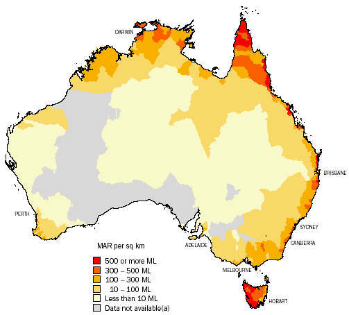
(a) Data not available for a number of reasons. Refer to <http://audit.ea.gov.au//> for more information.
Source: AWRC 1987a; AWRC 1987b; NLWRA 2001.
Table 24.26 summarises Australia's surface water stocks by drainage division. The drainage division with the highest intensity of run-off is Tasmania with 11.8% of the total from only 0.9% of the area. Conversely, the vast area of the Western Plateau, almost a third of Australia's total land area, has no significant run-off at all.
24.26 SURFACE WATER STOCKS - 2000
|
 | | Mean annual run-off |
| Area |
|
| Drainage division | sq km | GL | % |
|
| North-East Coast | 451,000 | 73,411 | 19.0 |
| South-East Coast(a) | 274,000 | 42,390 | 10.9 |
| Tasmania(b) | 68,200 | 45,582 | 11.8 |
| Murray-Darling Basin(a) | 1,060,000 | 23,850 | 6.2 |
| South Australian Gulf(c) | 82,300 | 952 | 0.2 |
| South-West Coast | 315,000 | 6,785 | 1.8 |
| Indian Ocean | 519,000 | 4,609 | 1.2 |
| Timor Sea | 547,000 | 83,320 | 21.5 |
| Gulf of Carpentaria | 641,000 | 95,615 | 24.7 |
| Lake Eyre | 1,170,000 | 8,638 | 2.2 |
| Bulloo-Bancannia | 101,000 | 546 | 0.1 |
| Western Plateau | 2,450,000 | 1,486 | 0.4 |
| Total | (d)7,680,000 | 387,184 | 100.0 |
|
(a) South-East Coast and Murray-Darling Division. The volume diverted represents the sum of available data (NSW has not reported water use for unregulated surface water management areas).
(b) Tasmanian Division. Volume diverted does not include the hydro-electric scheme diversions.
(c) South Australian Gulf Division. Mean annual outflow includes the flow from surface water management areas Willochra Creek and Lake Torrens, which do not flow to the sea, but flow into the terminal lake, Lake Torrens.
(d) Total area differs slightly from that in table 1.1, due to improvements in mapping reflected in that table, but not in this table.
Source: NLWRA 2001. |
Developed yield (also referred to as Economic Allocated volumes) is the average annual volume of water that can be diverted for use with the existing infrastructure (NLWRA 2001). Map 24.27 shows the developed yield as a percentage of MAR in 2000. The highest proportions are located in the south east and north east areas of Australia.
24.27 SURFACE WATER, DEVELOPED YIELD, By river basin - 2000
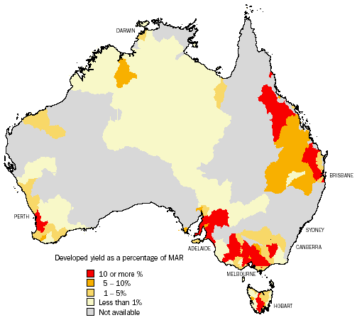
Source: AWRC 1987a; AWRC 1987b; NLWRA 2001.
Groundwater stocks
The volume of groundwater that exists in Australia is not known with certainty. The volume changes as water percolates through the ground to aquifers (underground water resources) and through water being extracted (e.g. from bores). Instead of an absolute measure of groundwater stock, a proxy is used. This is the amount of water that can be sustainably extracted, referred to as sustainable yield. Sustainable yield is defined as:
Level of extraction measured over a specified planning time frame that should not be exceeded to protect the higher value social, environmental and economic uses associated with the aquifer (NLWRA 2001).
The National Land and Water Resources Audit 2001 estimated the sustainable yield of groundwater in Australia to be 29,173 GL. Groundwater is not all of equal quality. In particular, the concentration of salt dissolved in water varies (map 24.28). The level of dissolved salt determines the potential uses of the water. The higher the salt level the less suitable the water is for human consumption or agriculture. Typically, a salinity level of more than 1,500 milligrams/litre (mg/L) restricts the use of water for irrigation. Map 24.28 shows the percentage of groundwater resource in each province with salinity over 1,500 (mg/L) in 2000. Salt occurs naturally in Australian soils but through irrigation and land clearing the levels of salt can increase in soils and water. Table 24.29 shows, proportionally, Northern Territory, Tasmania and Queensland have groundwater with the lowest salinity levels (less than 1,500 mg/L ), while Victoria, South Australia and Western Australia have groundwater with the highest salinity levels (1,500 mg/L and over).
24.28 GROUNDWATER, Salinity levels over 1,500 mg\L - 2000
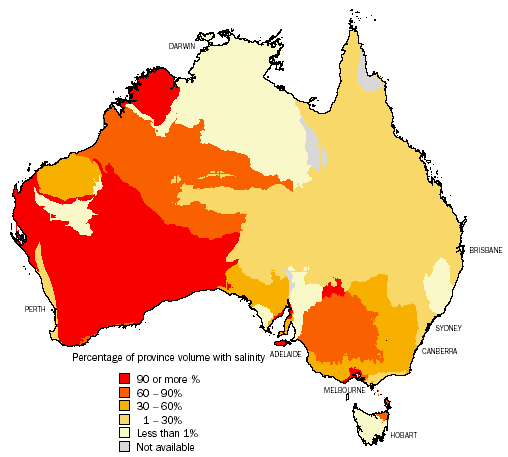
Source: Data based on NLWRA 2001.Australian Groundwater Provinces (2000) are based on data provided in 2000 with the permission of the Queensland Department of Natural Resources and Mines, Environment ACT, NSW Department of Land and Water Conservation, NT Department of Lands, Planning and Environment, SA Department of Water Resources, Tasmanian Department of Primary Industries, Water and Environment, Victorian Department of Natural Resources and the Environment, WA Water and Rivers Commission, and the Australian Surveying and Land Information Group.
24.29 SUSTAINABLE YIELD GROUNDWATER, By level of salinity - 2000
|
| | NSW | Vic. | Qld | SA | WA | Tas. | NT | Aust. |
| | GL | GL | GL | GL | GL | GL | GL | GL |
|
| Less than 1,500 mg/L | | | | | | | | |
| <500 mg/L | 698 | 194 | 1,373 | 56 | 1,899 | 1,585 | 4,412 | 10,217 |
| 500-1,000 mg/L | 3,928 | 827 | 995 | 229 | 1,061 | 767 | 287 | 8,093 |
| 1,000-1,500 mg/L | 34 | 386 | 119 | 679 | 995 | - | 455 | 2,670 |
| Total | 4,660 | 1,407 | 2,487 | 964 | 3,955 | 2,353 | 5,154 | 20,980 |
| 1,500 mg/L and over | | | | | | | | |
| 1,500-3,000 mg/L | 812 | 244 | 113 | 253 | 1,468 | 178 | 139 | 3,208 |
| 3,000-5,000 mg/L | 2 | 707 | 30 | - | 588 | - | 183 | 1,510 |
| 5,000-14,000 mg/L | 440 | 201 | 63 | 762 | 841 | - | - | 2,307 |
| More than 14,000 mg/L | - | 797 | - | - | 371 | - | - | 1,168 |
| Total | 1,254 | 1,949 | 206 | 1,015 | 3,268 | 178 | 322 | 8,193 |
| Total sustainable yield | 5,914 | 3,356 | 2,693 | 1,979 | 7,223 | 2,531 | 5,476 | 29,173 |
| Proportion (%) | | | | | | | | |
| Less than 1,500 mg/L | 79 | 42 | 92 | 49 | 55 | 93 | 94 | 72 |
| 1,500 mg/L and over | 21 | 58 | 8 | 51 | 45 | 7 | 6 | 28 |
|
| Source: AWRC 1987a; AWRC 1987b; NLWRA 2001. |
Water assets
There are several dimensions to water assets including the physical availability of water or water stocks, the administrative (e.g. licences and entitlements) and the physical infrastructure (dams, pipes, etc.) that are used to store and deliver water.
Information on the storage capacity of large dams in each state and territory (except the Australian Capital Territory) is available from the Register of Large Dams (Australian National Committee on Large Dams). There are approximately 500 large dams in Australia with a storage capacity of 84,793 GL. Tasmania (24,340 GL) and New South Wales (24,814 GL) have the largest storage capacity, while the Australian Capital Territory (124 GL) and South Australia (261 GL) have the least (graph 24.30). Most of Australia's dam capacity has been built since 1970 (graph 24.31).
|
 Print Page