This publication should be considered experimental, as improvements to methods and new data sources continue to become available. The ABS will be seeking input from key stakeholders with the intention of addressing issues and concerns in future updates.
Overview
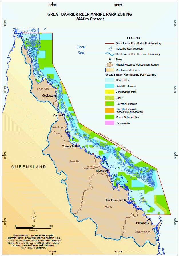
The Great Barrier Reef (GBR) is a globally significant area located in the Coral Sea off the coast of Australia. It extends for more than 2,300 kilometres along the north-eastern coast near the Australian state of Queensland. It is the world’s largest coral reef ecosystem and is listed on the register of World Heritage sites. The terrestrial (Great Barrier Reef Catchment Area) and marine (the Reef) ecosystems provide a number of benefits to humans through the generation and use of ecosystem services. The GBR Region consists of the GBR Marine Park along with the GBR Catchment Area, made up of six Natural Resource Management Regions (NRMRs), including Burdekin, Burnett Mary, Cape York, Fitzroy, Mackay Whitsunday and Wet Tropics.
Table 1. NRMR profiles, GBR region, 2011-2016
| NRMR Catchment Area | 2011 | 2016 | |||||
|---|---|---|---|---|---|---|---|
| Total Population | Population density | Aboriginal and Torres Strait Islander People % | Total Population | Population density | Aboriginal and Torres Strait Islander People % | ||
| sq km | ’000 | Person per sq km | % of total | 000’ | Person per sq km | % of total | |
| Burdekin | 135 251 | 222.1 | 1.6 | 7.1 | 232.6 | 1.7 | 7.9 |
| Burnett Mary | 55 612 | 301.1 | 5.4 | 3.7 | 316.9 | 5.7 | 4.4 |
| Cape York | 101 721 | 13.8 | 0.1 | 54.9 | 15.4 | 0.2 | 55.4 |
| Fitzroy | 157 834 | 227.8 | 1.4 | 4.8 | 235.5 | 1.5 | 5.6 |
| Mackay Whitsunday | 9 264 | 131.5 | 14.2 | 4.1 | 136.7 | 14.8 | 4.8 |
| Wet Tropics | 20 861 | 237.4 | 11.4 | 10.2 | 253.3 | 12.1 | 10.1 |
| Total GBR Region | 480 559 | 1 133.6 | 2.4 | 6.6 | 1 190.4 | 2.5 | 7.2 |
NRMRs are meshblock approximations of the Department of the Environment and Energy's Natural Resource Management regions to align with Australian Statistical Geography Standard.
Source: Terrestrial Extent and Condition section, 2011 Census of Housing and Population and 2016 Census of Housing and Population.
This publication uses the System of Environmental-Economic Accounting: Experimental Ecosystem Accounting (SEEA-EEA) international framework to integrate and track changes for complex biophysical data, economic data and other human activity. As an example, a key finding of this publication is the determination of ecosystem services input and tourism rent using a resource rent methodology. These estimate the value an ecosystem contributes to production after human inputs (such as labour, taxes, capital costs) are accounted for. Ecosystem services inputs were calculated for the Agriculture, Forestry, Fishing and Aquaculture industries and tourism rent was calculated for tourism activity.
Condition summary
A summary of the condition of the GBR Region from 2007-08 to 2014-15 is shown in Table 2.
Table 2. Ecosystem condition summary, GBR region, 2007-08 to 2014-15
| Units | 2007-08 | 2008-09 | 2009-10 | 2010-11 | 2011-12 | 2012-13 | 2013-14 | 2014-15 | ||
|---|---|---|---|---|---|---|---|---|---|---|
| Marine condition (inshore) | ||||||||||
| Coral (a) | Score | 47 | 48 | 47 | 43 | 38 | 39 | 40 | 44 | |
| Seagrass (a) | Score | 35 | 33 | 28 | 21 | 19 | 28 | 34 | 33 | |
| Water Quality (a) | Score | 47 | 44 | 44 | 31 | 37 | 37 | 34 | 43 | |
| Climate | ||||||||||
| Mean annual sea surface temperature (b) | Degrees Celsius | 24.7 | 25.0 | 25.7 | 24.5 | 24.9 | 25.1 | 24.9 | 25.2 | |
| Mean annual sea surface temperature anomaly (b) | Degrees Celsius | -0.27 | 0.30 | 0.53 | -0.38 | -0.16 | 0.12 | -0.11 | 0.24 | |
| Mean annual rainfall | mm | 1 070 | 1 090 | 946 | 1 633 | 1 100 | 903 | 869 | 760 | |
| Pollutant Loads in selected monitored areas (c) | ||||||||||
| Total Suspended Solids | Kilotonnes | 18 788.0 | 12 639.0 | 6 889.8 | 19 647.0 | 5 532.0 | 9 559.0 | 1 243.3 | 2 074.6 | |
| Total Nitrogen | Kilotonnes | 57.6 | 36.9 | 29.3 | 101.0 | 27.5 | 33.7 | 10.1 | 8.9 | |
| Total Phosphorus | Kilotonnes | 16.2 | 9.2 | 9.2 | 32.0 | 7.7 | 9.3 | 1.5 | 2.5 | |
a. Marine condition scores were sourced from the Reef Water Quality Protection Plan, Great Barrier Reef Report Card series (2015 issue).
b. Mean annual sea surface temperature and mean annual sea surface temperature anomaly are reported in calendar years from 2008 to 2015. These measures were sourced from the Bureau of Meteorology, eReefs Marine Water Quality Dashboard, Commonwealth of Australia.
c. Pollutant loads were sourced from the Department of Science, Information Technology and Innovation, Queensland Government.
Marine
Following the heavy rainfall events of 2010-11, marine ecosystems showed an overall decline in condition but started to show signs of recovery from 2012-13 to 2014-15. Marine condition is heavily influenced by cyclones, severe weather events, rainfall and pollutant run-off.
- Water quality scores in the GBR Region and all six NRM regions declined between 2007-08 and 2010-11, after large storm and flooding events, and then fluctuated through to 2014-15. There were five Category 5 cyclones in the region between 2006 and 2015, following a period from 1970 until 2006 where there were no Category 5 cyclones recorded, highlighting the increase in frequency and severity of storms in recent years.
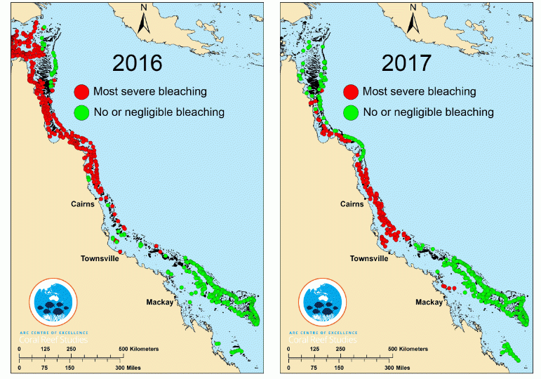
- From 2005-06 to 2014-15, the coral condition decreased, based on coral condition scores presented in the Great Barrier Reef Report Card 2015. All NRM regions reported an increase from 2013-14 to 2014-15, following large decreases after the 2010-11 flooding events. Coral condition change is a balance between disturbance events and regrowth rates. Repeated disturbances such as the 2016 and 2017 bleaching events and increased cyclone events are likely to both directly damage and reduce coral condition and to impact on regrowth rates. It should be noted that these last two bleaching events occurred outside the reference period for this publication, with respect to coral condition scores, and the impact of these will be reflected in future updates.
- Seagrass decline is thought to be due to a range of impacts such as deposition of nutrients and sediments from agriculture, and marine-based activities such as dredging and anchor damage. In the last few years, the trending decline of seagrass meadows appears to have slowed and in some cases reversed, in part due to decreased rainfall leading to lower volumes of discharge and river loads.
- The abundance of selected fish species has remained relatively stable across the majority of NRM region marine extensions between 2001 and 2017. The exception is the Burnett Mary NRM region, which experienced an overall decrease of 11% in the number of fish species recorded between 2001 and 2017.
Terrestrial
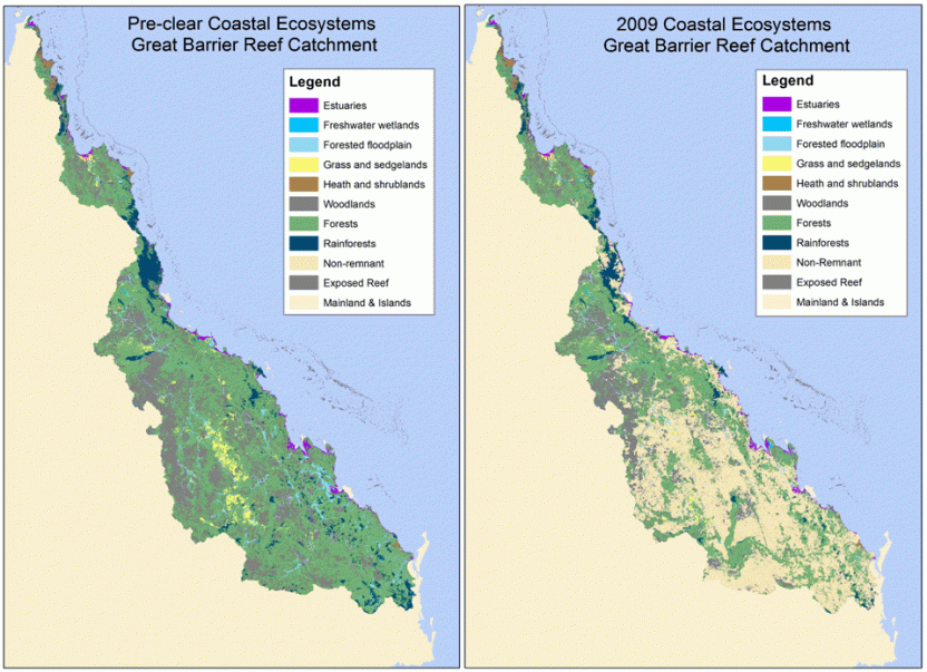
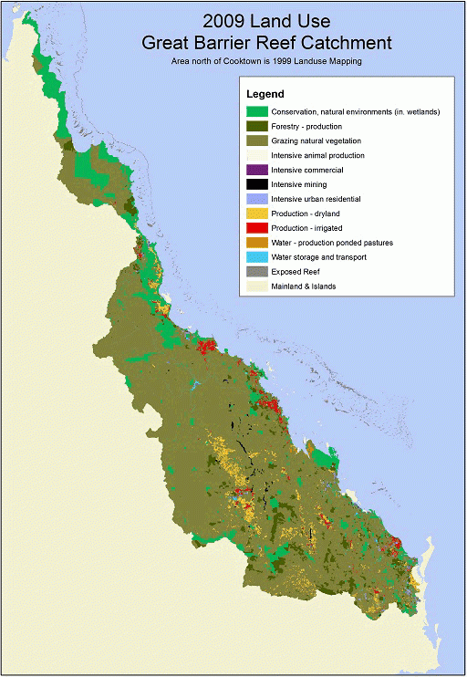
The greatest land use within the GBR Catchment Area was Livestock grazing, accounting for 67% of the total land use, in both 2011 and 2016. A matrix land account that integrates land use and dynamic land cover is presented in the Terrestrial Extent and Condition section of this publication.
- The predominance of Livestock grazing means that, as well as being a major source of value to the agriculture industry, the nature of grazing activity and practices will have an influence over the ecosystem regulatory services capacity of the catchment. This is discussed in more detail in the Ecosystem Regulatory Services section of this publication.
- In recent years, Livestock grazing expanded, in net terms, into land which was previously classed as Vacant residential and Other agriculture - cropping, while losing land, in net terms, to land classed to Extractive industries.
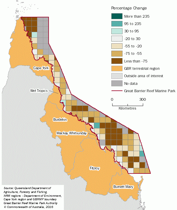
- Pollutant loads move from land into rivers, then into the Marine Park, and are monitored as 'river loads', measured at catchment end-of-system sites. Monitored pollutant loads leaving catchments vary considerably from year-to-year, mainly due to differences in annual rainfall and runoff. Overall, the Burdekin and Fitzroy NRM regions contributed the highest quantity of total suspended solids (fine sediment) and nutrient river loads between 2006-07 and 2014-15.
- No land use information available.
- Land uses categories have been created almagated for the presentation of this graph.
- This includes land uses that could not be allocated to AVPCC.
Biodiversity
- Biodiversity in the GBR Region contributes significantly to the health of the Reef and its Outstanding Universal Value (OUV) and is incorporated in estimates of these factors.
- In the GBR Region between 1994 and 2017, Birds and Reptiles showed little overall movement between threat categories. Four extra species of Mammals became Vulnerable, while Fish and Invertebrates saw two and three species, respectively, become Endangered. Frogs fared worst among the groups of fauna, with ten species added to the Endangered category, one species to Vulnerable, and five to Near Threatened. The primary threat to each faunal group was habitat loss and degradation; other key threats across all groups were feral species and climate change. Species in scope are those deemed threatened according to the Queensland Nature Conservation Act 1992, with a distribution range within the GBR Region.
Ecosystem services
A summary of benefits produced using ecosystem services in physical measures for the GBR Region (2006-07 to 2015-16) is presented in Table 3.
Table 3. Benefits produced using ecosystem services in physical measures, GBR region, 2007-08 to 2015-16
| 2007-08 | 2008-09 | 2009-10 | 2010-11 | 2011-12 | 2012-13 | 2013-14 | 2014-15 | 2015-16 | |||
|---|---|---|---|---|---|---|---|---|---|---|---|
| Provisioning Services | |||||||||||
| Food - Meat cattle | tonnes | 496 935.7 | 476 429.3 | 424 719.8 | 451 056.3 | 469 908.0 | 457 618.4 | 570 682.4 | 586 460 | na | |
| Food - Sugar | tonnes | 29 404 592.0 | 29 299 735.0 | 28 262 411.0 | 23 054 570.0 | 23 430 217.8 | 25 738 628.0 | 28 483 702.0 | 29 591 927.9 | na | |
| Food - Other food | tonnes | 3 092 298 | 2 323 465 | 2 634 682 | 2 015 614 | 2 427 179 | 2 124 068 | 2 297 696 | 2 231 453 | na | |
| Agricultural materials | tonnes | 218.6 | 459.2 | 166.1 | 201.5 | 278.5 | 277.2 | 314.8 | 379.1 | na | |
| Fishing | tonnes | 10 967 | 12 061 | 11 525 | 10 645 | 9 052 | 9 837 | 8 889 | 8 593 | 8 259 | |
| Aquaculture | tonnes | 4 500.5 | 4 270.5 | 5 898.8 | 5 492.6 | 5 056 | 5 064.3 | 5 397.8 | 6 662.1 | 6 470.9 | |
| Timber | m³ | na | na | na | 914 988.5 | 977 852.2 | 726 365.9 | 735 115.4 | 886 748.2 | na | |
| Regulating Services | |||||||||||
| Carbon stored (a) | Megatonnes | 2 849.0 | 2 844.3 | 2 841.7 | 2 838.7 | 2 833.4 | 2 831.7 | 2 830.7 | 2 827.8 | 2 826.7 | |
| Cultural Services | |||||||||||
| Visitors | millions | 15.2 | 15.2 | 15.0 | 16.4 | 14.5 | 17.8 | 17.3 | 16.9 | 17.8 | |
a. Amount of carbon stored at the end of the financial year
na - data not available
Source: Summary of data from tables in relevant sections of this publication.
- Of the provisioning services identified, sugar provided the greatest contribution in volume in 2014-15, with 29.6 million tonnes produced; this was an increase of 4% from 2013-14.
- The biocarbon stored in the GBR Catchment Area decreased by 21.2 megatonnes (-1%) from 2007-08 to 2014-15, highlighting changes to landscape within the region.
The value of the benefits for selected ecosystem services is summarised in Table 4. Meat cattle had the greatest value of production in the region, accounting for 43% of the total food production in 2014-15. Tourism consumption peaked in 2012-13, with total consumption of $9,432 million.
Table 4. Value of benefits produced using ecosystem services, GBR region, 2006-07 to 2014-15
| Units | 2006-07 | 2007-08 | 2008-09 | 2009-10 | 2010-11 | 2011-12 | 2012-13 | 2013-14 | 2014-15 | ||
|---|---|---|---|---|---|---|---|---|---|---|---|
| Provisioning Services | |||||||||||
| Food - Meat cattle | $m | na | 1 594.3 | 1 598.0 | 1 338.5 | 1 478.6 | 1 537.8 | 1 423.5 | 1 887.0 | 2 393.4 | |
| Food - Sugar | $m | na | 788.7 | 992.4 | 1268.4 | 867.3 | 1 034.8 | 1 055.6 | 1 139.8 | 1 195.2 | |
| Food - Other food | $m | na | 1 799.4 | 1 813.4 | 1 667.2 | 1 690.1 | 1 693.1 | 2 011.2 | 1 891.2 | 1 923.7 | |
| Agricultural materials | $m | na | 177.2 | 205.6 | 220.1 | 213.2 | 254.6 | 237.3 | 251.9 | 201.8 | |
| Timber | $m | na | na | na | na | 80.4 | 75.0 | 59.4 | 59.9 | 77.3 | |
| Fishing | $m | na | 118.1 | 127.0 | 125.8 | 112.3 | 100.1 | 109.1 | 115.6 | 105.2 | |
| Aquaculture | $m | na | 49.4 | 58.9 | 50.5 | 62.8 | 62.0 | 60.6 | 67.8 | 86.0 | |
| Cultural Services | |||||||||||
| Tourism consumption | $m | 8 093.0 | 8 387.9 | 8 036.7 | 8 395.6 | 7 692.9 | 9 066.2 | 9 435.1 | 8 976.1 | 9 167.1 | |
na - data not available
Source: Summary of data from tables in relevant sections of this publication.
The impacts of severe weather events in 2010-11 (including extremely high rainfall, cyclones and flooding) on agricultural production appear to have been broadly negative, with marked declines in tonnes produced in sugar (-19%), horticulture (-26%) and broadacre crops (-25%). Livestock meat production appears to have been only modestly impacted. A relationship can be drawn between agricultural production and practices and the impact of agricultural runoff on water quality, but the data also suggests that the timing of any such impacts may be determined more by peak rainfall events than by timing of productive activity.
Table 5 presents a summary of ecosystem service input (resource rent) for selected industries in the GBR Region.
Table 5. Ecosystem service input (resource rent method) selected industries, GBR region, 2006-07 to 2014-15
| Industry | Units | 2006-07 | 2007-08 | 2008-09 | 2009-10 | 2010-11 | 2011-12 | 2012-13 | 2013-14 | 2014-15 | |
|---|---|---|---|---|---|---|---|---|---|---|---|
| Ecosystem services input (resource rent method) | |||||||||||
| Agriculture | $m | na | 205.4 | 433.8 | 410.4 | 636.9 | 980.7 | 1 049.1 | 972.7 | 1 226.5 | |
| Forestry | $m | na | na | na | na | 9.4 | 16.5 | 11.2 | 15.3 | 28.5 | |
| Fishing and Aquaculture | $m | na | 35.0 | 42.0 | 42.0 | 35.0 | 44.0 | 39.0 | 46.0 | 45.0 | |
| Tourism rent | |||||||||||
| Tourism (a) | $m | 310.6 | 332.6 | 290.9 | 320.7 | 299.0 | 404.2 | 535.0 | 470.0 | 523.3 | |
a. Tourism rent contains ecosystem services input as well as other non-produced tourist attraction inputs; see Tourism section and Explanatory Notes
na - data not available
Source: Summary of data from tables in relevant sections of this publication
- Ecosystem services input, as calculated by the resource rent method, is the residual value after deducting labour, materials and produced capital as inputs to production. It is defined as the input by ecosystem services to production.
- In 2014-15 the ecosystem services input for GBR Region Agriculture was $1.2 billion. This ecosystem services input was 44% of Gross Operating Surplus for Agriculture, and has risen as a share of Gross Operating Surplus from 12% in 2007-08. This rise was due to a number of factors, including the end of the Millennium Drought during the 2000s and declining costs of produced capital since the Global Financial Crisis.
- Tourism rent in 2015-16 was $0.6 billion, or 15.6% of tourism GVA. Tourism rent is the resource rent calculated as a value extracted from all tourist attractions. Ecosystems feature prominently among tourist attractions in the GBR Region.
Expenditure of environmental goods and services
- In terms of the total $494 million expenditure on environmental goods and services aimed at protecting the Reef, local government was the largest contributor to these expenditures, accounting for $229 million (46% of total), followed by the Australian Government with $145 million (29%), Queensland Government $78 million (16%) and non-government sources $41 million (8%).
Tourism
- The number of visitors to the GBR Region increased from 15.2 million in 2007-08 to 17.8 million in 2015-16. This change is reflected in the value of direct tourism consumption, which increased from $8.4b to $10.0b.
- The number of visits to the Great Barrier Reef Marine Park increased from 1.9 million to 2.3 million across the reference period. The value of revenue collected in the Marine Park increased by 20% in the same period, from $7.3 million to $8.8 million, due to gradual increases in part-day and full-day charges.
- Tourism employed about 46,000 people in the GBR Region in 2015-16. Between 2010-11 and 2014-15 tourism employment contributed about 8.2%, on average, of total employment in the region. This would make tourism, if counted as an industry, one of the more significant employing industries in the region. As a comparison, Education and Training jobs made up about 8.1% of total jobs in 2011-12.
- The Wet Tropics NRM region, centred around Cairns, records much higher tourism expenditure than in other NRM regions with comparable or greater numbers of total visitors. The region sees significantly more international visitors (4.8 million visitors in 2015-16) than any other NRM region. The attractiveness of the area is likely due in part to its positioning as a well-known destination, specifically for tropical ecosystem related attractions. Cairns and Port Douglas are two of the major launching point for tours to the Great Barrier Reef, as the Reef is quite close to the shoreline in this part of the catchment compared with further south.
Fishing and aquaculture
- This account highlights linkages between changes to the regulatory environment for fishing in the GBR Region and subsequent changes to the richness of fish species observed. Between 2003-04 and 2004-05 the value of fishing production in the region fell by $45.7 million (25%); fishing tonnage produced fell by 27%, number of licences was down 16% and fishing effort in person days fell 22%. Production per person day of effort was largely unchanged during this transition. The GBR Marine Park was rezoned in 2004, coinciding with a Commonwealth government buy back of a portion of commercial fishing licence quotas and a number of other drivers of reduced fishing activity which are detailed in the relevant section of this publication
- With the reduction in fishing production, the fish abundance scores observed in the Marine Park show that abundance has been substantially maintained, exhibiting fluctuations in year to year observations but with no clear decline trend. Fish abundance scores are a measure of marine condition - for further discussion, refer to the section on Marine Extent and Condition.
- Across the full reporting period 2001-02 to 2015-16, the value of fishing production decreased by 46%, from $190 million to $104 million. Physical production decreased by 46%, from 15,341 tonnes to 8,259 tonnes, over the same period. Licence numbers and fishing effort also decreased by 52% and 45% respectively.
- The resource rent of fishing increased by 62%, from $28 million to $45 million, between 2004-05 and 2014-15.
Water
- The use of water for irrigation in agricultural activities in the GBR Catchment Area has increased from 2010-11 to 2015-16 by an estimated 135%, from 773,979 ML in 2010-11 to 1,821,593 ML in 2015-16. Burdekin was the NRM region that accounted for the largest proportion of water use in the GBR Catchment Area, representing 58% of water used for agricultural activity in 2015-16.
- In 2014-15, the gross value of irrigated agricultural production in the GBR Catchment Area was $2.2 billion. Of this, Sugar had the highest value of irrigated production, accounting for 32% of the total in 2014-15, and used 69% of total water applied to agricultural activity.
- As of June 2016, 760,649 ML of water was stored in large urban dams and 4,429,438 ML of water was stored in large rural dams.
Carbon
- 'Forests' stored the greatest amount of carbon above and below ground in the GBR Region, with a total of 2,134 Mt C (76%) in 2015-16, followed by 'Grasslands' and 'Mangroves', with 435 Mt C (15%) and 149 Mt C (5%) respectively. While 'Mangroves' only accounted for 5% of the total stored carbon in the GBR Region, they recorded the highest density, 687 tonnes per hectare.
- The rate of decrease in carbon stocks was very rapid between 1989 and 1997, but has slowed in recent years. This reduced rate of loss of biocarbon can be attributed to forest regrowth and slowing of losses from grasslands, resulting in net gain of forest carbon stocks from 2008 to present. Although forest carbon has increased, there has still been an overall net decrease of biocarbon stored in the GBR Region.